Maps of Operation Overlord
Jump to navigation
Jump to search
-
 Weather map of June 5th 1944, D-Day minus 1 day
 -
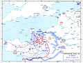
 Combined Bomber Offensive and German depositions 6 June 1944
 -
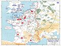
 German depositions in France 1944
 -
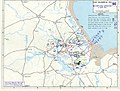
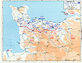
 Allied invasion plans and german positions in the Normandy
 -
 Utah Beachhead - 6 June 1944
 -
 Utah beach 6 June 1944
 -
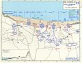 Omaha beachhead 6 June 1944
 -
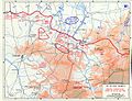
 Normandy 13 - 30 June 1944
 -
 Development of Lodgment in Normandy area as planned by 21st Army Group in February 1944
 -
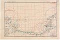 Chart of D-Day Beaches, 04/14/1944
 -
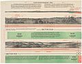 Panoramic Sketch of the D-Day Beaches, 05/14/1944
 -

-
 Expanding the beachhead - 1-24 July 1944
 -
 Saint Lo and Vicinity - German dispositions - Night of 24/25 July 1944
 -
 Saint Lo and Vicinity - Operation Cobra - 25-29 July 1944
 -
 Saint Lo Breakthrough - 25-31 July 1944
 -
 The Breakout - 1-13 August 1944
 -
 The Exploitation - 14-25 August 1944
 -
 diagram


For further maps see: World War II maps (Europe)