Commons:NIMH donation 2017
Jump to navigation
Jump to search
| Netherlands Institute for Military History
|
|||
|---|---|---|---|
.svg) |
|||
| Native name | Nederlands Instituut voor Militaire Historie (NIMH) | ||
| Parent institution | Ministry of Defence | ||
| Location | |||
| Coordinates | | ||
| Established | 1 July 2005 | ||
| Website | NIMH | ||
| Authority file | |||
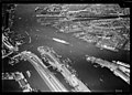
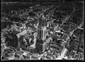
In 2017, Nederlands Instituut voor Militaire Historie (Netherlands Institute of Military History) donated 1142 aerial photographs of the Netherlands to Wikimedia Commons. They were taken in the years 1920-1940 by the Technische Dienst Luchtvaartafdeeling (precursor of the present Royal Netherlands Air Force) and show towns, castles and fortifications.
Gallery
[edit]Some samples:
Towns
[edit]-
 Waag, Amsterdam
 -
 Paleis voor Volksvlijt in Amsterdam before...
 -
 ...and after it burned down in 1929.
 -
-
 Leiden city hall on the Breestraat after the fire of 1929.
 -
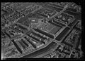
 Rotterdam city center before destruction by the German airforce in 1940. City hall at the right.
 -


Castles and monuments
[edit]-

-
 Peace Palace, The Hague
 -
 De Rode Olifant, The Hague
 -
-
-
 Kasteel Weldam
 -


Fortifications
[edit]-

-
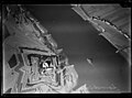
 Fort Roovers
 -
 Fort Sabina Henrica
 -
 Spaarndam
 -
 Fort Schiphol
 -
 Fort Uitermeer
 -
 Fort Vechten


Miscellaneous
[edit]-
 ENKA rayon factory, Ede
 -
 Inundation of Gennep by the Meuse, 1926
 -
 Katwijk
 -
 Kornwerderzand, Afsluitdijk
 -

-
 Demolition of a bridge near Nieuwersluis
 -
 Oostvoorne
 -
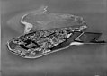 Urk as an island before reclamation in the Noordoostpolder.
.jpg)


