Category:Sylhús (Hindeloopen)
Jump to navigation
Jump to search
| Object location | | View all coordinates using: OpenStreetMap |
|---|
building in Súdwest-Fryslân, Netherlands  | |||||
| Upload media | |||||
| Instance of | |||||
|---|---|---|---|---|---|
| Location | Hindeloopen, Hindeloopen | ||||
| Located on street | |||||
| Heritage designation |
| ||||
 | |||||
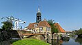
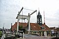
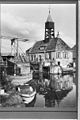
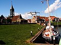
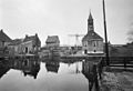
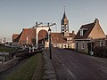
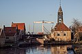
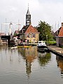
English: The Sylhús, a seventeenth century lockmasters house in Hindeloopen, a city in the Dutch province of Friesland.
Frysk: It Sylhús yn Hylpen. De slûswachterswente is setten yn de santjinde ieu, de klokketoer is pleatst yn de njoggentjinde.
Nederlands: Het Sylhús, een sluiswachterswoning in Hindeloopen. Het pand dateert uit de zeventiende eeuw, de klokkentoren uit de negentiende.
|
This is a category about rijksmonument number 22191
|
| Address |
|
Media in category "Sylhús (Hindeloopen)"
The following 53 files are in this category, out of 53 total.
-
 20080504 Zijlroede Hindeloopen NL.jpg 3,000 × 785; 382 KB
-
 20140430 Sluis en sluiswachterswoning (Sylhús) Hindeloopen Fr NL.jpg 5,400 × 3,000; 4.57 MB
-
 20180719 Zicht op het Sylhus vanaf de Wipbrug in Hindeloopen.jpg 4,958 × 3,302; 2.76 MB
-
 20180719 Zicht op Hindeloopen vanaf de brug over de Aesterfaart2.jpg 5,020 × 3,346; 3.87 MB
-
 20190717 Zicht1 op het Sylhus vanaf de Wipbrug in Hindeloopen.jpg 5,184 × 3,456; 3.79 MB
-
 20190717 Zicht2 op het Sylhus vanaf de Wipbrug in Hindeloopen.jpg 5,184 × 3,456; 2.86 MB
-
 20190717 Zicht3 op het Sylhus vanaf de Wipbrug in Hindeloopen.jpg 5,184 × 3,456; 3.49 MB
-
 8713 Hindeloopen, Netherlands - panoramio (11).jpg 1,375 × 2,048; 459 KB
-
 8713 Hindeloopen, Netherlands - panoramio (12).jpg 2,048 × 1,375; 387 KB
-
 8713 Hindeloopen, Netherlands - panoramio (13).jpg 1,375 × 2,048; 552 KB
-
 8713 Hindeloopen, Netherlands - panoramio (18).jpg 2,048 × 1,375; 521 KB
-
 8713 Hindeloopen, Netherlands - panoramio (29).jpg 2,048 × 1,375; 467 KB
-
 8713 Hindeloopen, Netherlands - panoramio (39).jpg 2,048 × 1,375; 508 KB
-
 8713 Hindeloopen, Netherlands - panoramio (49).jpg 4,981 × 3,456; 10.63 MB
-
 Aanzicht - Hindeloopen - 20113483 - RCE.jpg 802 × 1,200; 207 KB
-
 Exterieur - Hindeloopen - 20113480 - RCE.jpg 1,200 × 844; 206 KB
-
 Exterieur - Hindeloopen - 20113481 - RCE.jpg 840 × 1,200; 149 KB
-
 Exterieur - Hindeloopen - 20113482 - RCE.jpg 1,200 × 1,188; 335 KB
-
 Exterieur BRUG - Hindeloopen - 20285070 - RCE.jpg 1,195 × 1,200; 287 KB
-
 Exterieur OVERZICHT - Hindeloopen - 20285069 - RCE.jpg 1,177 × 1,200; 243 KB
-
 Exterieur OVERZICHT - Hindeloopen - 20285072 - RCE.jpg 1,191 × 1,200; 272 KB
-
 Exterieur OVERZICHT ACHTERGEVEL - Hindeloopen - 20285075 - RCE.jpg 1,184 × 1,200; 337 KB
-
 Exterieur OVERZICHT RECHTER ZIJGEVEL - Hindeloopen - 20285074 - RCE.jpg 1,192 × 1,200; 248 KB
-
 Exterieur OVERZICHT SLUIS - Hindeloopen - 20285071 - RCE.jpg 1,179 × 1,200; 268 KB
-
 Exterieur OVERZICHT VOORGEVEL - Hindeloopen - 20285073 - RCE.jpg 1,188 × 1,200; 320 KB
-
 Haven, dorpsgezicht - Hindeloopen - 20446998 - RCE.jpg 1,200 × 900; 147 KB
-
 Hindeloopen - de Zijlroede 2021.jpg 4,624 × 3,468; 4.43 MB
-
 Hindeloopen Zijlroede.JPG 3,872 × 2,592; 3.64 MB
-

-
 Hindeloopen. Sylhús. 30-03-2021. (d.j.b) 02.jpg 2,947 × 5,000; 14.22 MB
-
 Hindeloopen. Sylhús. 30-03-2021. (d.j.b) 03.jpg 5,095 × 3,397; 16.19 MB
-
 Hindeloopen. Sylhús. 30-03-2021. (d.j.b).jpg 4,761 × 2,133; 8.38 MB
-
 Hindeloopen003.jpg 480 × 360; 167 KB
-
 Holland Hindeloopen 2004 012.jpg 2,304 × 1,728; 1.32 MB
-
 Holland Hindeloopen 2004 019.jpg 2,304 × 1,728; 1.49 MB
-
 Overzicht 't Oost - Hindeloopen - 20113472 - RCE.jpg 1,200 × 812; 186 KB
-
 Overzicht 't Oost met sluis - Hindeloopen - 20113468 - RCE.jpg 1,200 × 815; 153 KB
-
 Overzicht 't Oost met sluis - Hindeloopen - 20113475 - RCE.jpg 1,200 × 811; 211 KB
-
 Overzicht - Hindeloopen - 20113478 - RCE.jpg 1,200 × 867; 177 KB
-
 Overzicht - Hindeloopen - 20113566 - RCE.jpg 1,188 × 1,200; 325 KB
-
 Overzicht - Hindeloopen - 20113567 - RCE.jpg 1,192 × 1,200; 308 KB
-
 Overzicht Kalverstraat naar het oosten - Hindeloopen - 20113409 - RCE.jpg 1,200 × 822; 156 KB
-
 Overzicht vanaf brug Wipbrugsteeg - Hindeloopen - 20113465 - RCE.jpg 1,200 × 819; 160 KB
-
 Rechter zijgevel- achterbouw - Hindeloopen - 20113573 - RCE.jpg 1,190 × 1,200; 371 KB
-
 Schutsluis in Hindeloopen. 30-03-2021. (actm) 01.jpg 3,902 × 2,686; 8.63 MB
-
 Schutsluis in Hindeloopen. 30-03-2021. (actm) 02.jpg 4,319 × 3,170; 12.45 MB
-
 Schutsluis in Hindeloopen. 30-03-2021. (actm) 03.jpg 4,660 × 2,994; 11.79 MB
-
 Schutsluis met houten ophaalbrug 2.jpg 2,309 × 1,732; 1.67 MB
-
 Schutsluis met houten ophaalbrug in Hindeloopen.jpg 2,449 × 1,633; 1.58 MB
-
 Schutsluis met houten ophaalbrug.jpg 2,449 × 1,633; 1.72 MB
-
 Sluis Hindeloopen.jpg 3,648 × 2,736; 1.1 MB
-
 Sluishuis, aanzicht - Hindeloopen - 20113603 - RCE.jpg 1,200 × 805; 150 KB
-
 Sluiswachterswoning Hindeloopen.jpg 2,675 × 3,567; 626 KB
_Hindeloopen_Fr_NL.jpg)


.jpg)
.jpg)
.jpg)
.jpg)
.jpg)
.jpg)
.jpg)


_02.jpg)
_03.jpg)
.jpg)


_01.jpg)
_02.jpg)
_03.jpg)


