Category:Maps of the Philippines
Jump to navigation
Jump to search
Countries of Asia: Afghanistan · Armenia‡ · Azerbaijan‡ · Bahrain · Bangladesh · Bhutan · Brunei · Cambodia · People's Republic of China · Cyprus‡ · East Timor · Egypt‡ · Georgia‡ · India · Indonesia‡ · Iran · Iraq · Israel · Japan · Jordan · Kazakhstan‡ · Kuwait · Kyrgyzstan · Laos · Lebanon · Malaysia · Maldives · Mongolia · Myanmar · Nepal · North Korea · Oman · Pakistan · Philippines · Qatar · Russia‡ · Saudi Arabia · Singapore · South Korea · Sri Lanka · Syria · Tajikistan · Thailand · Turkey‡ · Turkmenistan · United Arab Emirates · Uzbekistan · Vietnam · Yemen
Limited recognition: Abkhazia‡ · Taiwan · Northern Cyprus‡ · State of Palestine · South Ossetia‡ – Other territories: Akrotiri and Dhekelia‡ · British Indian Ocean Territory · Hong Kong · Macau
‡: partly located in Asia
Limited recognition: Abkhazia‡ · Taiwan · Northern Cyprus‡ · State of Palestine · South Ossetia‡ – Other territories: Akrotiri and Dhekelia‡ · British Indian Ocean Territory · Hong Kong · Macau
‡: partly located in Asia
Wikimedia category | |||||
| Upload media | |||||
| Instance of | |||||
|---|---|---|---|---|---|
| Category combines topics | |||||
 | |||||
Subcategories
This category has the following 46 subcategories, out of 46 total.
A
B
C
D
E
F
G
H
I
L
M
O
P
R
S
T
W
Pages in category "Maps of the Philippines"
This category contains only the following page.
Media in category "Maps of the Philippines"
The following 200 files are in this category, out of 221 total.
(previous page) (next page)-
 07973jfTarlac Municipal Hall Compound Capasfvf 29.JPG 4,608 × 3,456; 6.46 MB
-
 07973jfTarlac Municipal Hall Compound Capasfvf 30.JPG 4,608 × 3,456; 6.54 MB
-
 07973jfTarlac Municipal Hall Compound Capasfvf 31.JPG 4,608 × 3,456; 6.66 MB
-
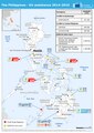
 20141030 Philippines EU assistance 2013-2014.png 793 × 1,122; 445 KB
-
 20151016 ECHO The Philippines EU assistance 2014-15.pdf 1,239 × 1,754; 501 KB
-
 20151016 ECHO The Philippines EU assistance 2014-15.png 794 × 1,123; 416 KB
-
 21-01-205-bataan.jpg 1,368 × 2,048; 1.94 MB
-
 75967 South-China-Sea-1.jpg 9,570 × 6,660; 30.8 MB
-
 75967 South-China-Sea-1.pdf 1,754 × 1,239; 3.71 MB
-

-
 Affected Philippine provinces by typhoon Bilis 2006.png 2,000 × 3,120; 192 KB
-
 Affected Philippine provinces by typhoon Xangsane 2006.png 2,000 × 3,120; 193 KB
-
-
 Atlas of the Philippine Islands (1900) map 06.jpg 5,000 × 6,000; 4.93 MB
-
 Biogeographic regions of the Philippines.PNG 157 × 253; 4 KB
-
 Birthplace Map of Philippine Prime Ministers.png 2,000 × 3,120; 197 KB
-
 Blia map english.jpg 713 × 795; 96 KB
-
 Calinaoan Centro Political Map.png 847 × 453; 110 KB
-
 Cavity City map.jpg 5,500 × 4,250; 4.35 MB
-
 CBCS Coverage.JPG 727 × 589; 54 KB
-
 Cebu earthquake 2012.jpg 612 × 684; 225 KB
-
 Cebu Pacific Route Map - Domestic.png 2,000 × 3,120; 1.02 MB
-
 Citiesthativebeen.png 410 × 639; 76 KB
-
 Clark ab - dotmap.jpg 360 × 471; 20 KB
-
 Coconut Growing Zones.png 500 × 596; 197 KB
-
 Communist hotspots in the Philippines.png 300 × 440; 9 KB
-
 Dasmariñas map.jpg 5,500 × 4,250; 3.22 MB
-
 Division of the Philippines Showing Stations Occupied by Troops - NARA - 109181703.jpg 12,704 × 20,337; 18.31 MB
-
 Earthquake Philippines 23 July 2010.jpg 612 × 684; 209 KB
-
 ECHO Philippines BaseMap A4 Landscape.png 3,509 × 2,481; 398 KB
-
 Eq density small.jpg 211 × 321; 18 KB
-
 Eq density.jpg 291 × 336; 23 KB
-
 TribalPhilippinesTraditionalRange.png 2,000 × 3,120; 208 KB
-
 Features in the West Philippine Sea (Portrait).jpg 9,933 × 14,043; 6.09 MB
-
 Features in the West Philippine Sea.jpg 14,043 × 9,933; 6.2 MB
-
 Filipiinid.png 934 × 1,498; 152 KB
-

-
 FLII Philippines.png 685 × 835; 177 KB
-
Foraging-Behaviour-and-Landscape-Utilisation-by-the-Endangered-Golden-Crowned-Flying-Fox-(Acerodon-pone.0079665.s001.ogv 1 min 0 s, 1,728 × 1,436; 3.21 MB
-
 GatewayRegion10.jpg 1,600 × 800; 113 KB
-
 Gebiet der Philippinen - 01.jpg 640 × 1,101; 55 KB
-
 General Trias City map.jpg 5,500 × 4,250; 2.38 MB
-
 Home provinces of Philippine vice presidents 2022.jpg 794 × 1,123; 249 KB
-
 Human migration into the Philippines and Basilan.jpg 2,067 × 2,022; 725 KB
-
 Iloilo International Airport air routes.png 784 × 900; 130 KB
-
 Indonesia philippines eez boundary.jpg 975 × 868; 678 KB
-
 YolandaPSWS eo.png 1,074 × 665; 20 KB
-
 Katagalugan.png 2,000 × 3,120; 196 KB
-
 Kingdom of Jambangan2.jpg 3,180 × 4,961; 721 KB
-
 Lancaster New City Cavite Alapan Imus and San Sebastian Kawit Hazard map.jpg 1,301 × 925; 183 KB
-
 Lancaster New City Cavite Northern Barangay Navarro Flood Hazard map.jpg 1,478 × 923; 221 KB
-
 Lancaster New City Cavite Southern Barangay Navarro Flood Hazard map.jpg 1,543 × 926; 189 KB
-
-
 Landing Fields - Philippines - Naguilian - NARA - 68160376.jpg 5,428 × 6,902; 4.86 MB
-
 Legislative districts of the Philippines 2007.PNG 2,000 × 3,120; 246 KB
-
 Limno.jpg 1,012 × 1,384; 479 KB
-
 Locations Important in Gaddang History.png 1,481 × 679; 1.59 MB
-
 LocMap of WH Rice Terraces of the Philippine Cordilleras ja.png 280 × 350; 10 KB
-
 Luzon regions.png 1,449 × 2,365; 224 KB
-
 Luzviminda-ar.png 300 × 450; 30 KB
-
 Luzviminda.png 300 × 450; 22 KB
-
 MajorVolcanoesOfThePhilippines-USGS.gif 336 × 594; 18 KB
-
 Manilla 1766.jpg 6,400 × 3,630; 24.9 MB
-
 Manilla Raid (1798).png 857 × 1,149; 566 KB
-
 Map of Bien Unido.png 2,754 × 2,480; 426 KB
-
 Map of Lanao del Sur.png 610 × 517; 128 KB
-
 Map of Philippines (square).jpg 128 × 128; 10 KB
-
 Map of the Municipality of Ubay, Bohol in the Philippines.png 3,144 × 2,550; 802 KB
-
 Map of the Philippines and the adjacent countries.png 640 × 360; 99 KB
-
 MapImage map.gif 475 × 656; 182 KB
-
 MapNPA2018.jpg 620 × 830; 823 KB
-
 Mapphilippines.jpg 342 × 828; 56 KB
-
 Mataas na Gulod - Palay Palay Protected Landscape Relief Map.jpg 2,679 × 1,714; 1.43 MB
-
 Membership 05032013.png 2,000 × 3,120; 502 KB
-
-
 Miss Universe Philippines 2020.png 2,000 × 3,120; 143 KB
-
 MUPH2023 Results.svg 4,000 × 4,383; 1.65 MB
-
 NAMRIA map of Philippine maritime zones.png 644 × 665; 327 KB
-
 PacificTheaterAug1942.jpg 1,199 × 873; 256 KB
-
 Panay-Lage.png 330 × 474; 27 KB
-
 PAT - Philippines.gif 800 × 1,090; 120 KB
-
 Ph congress 1.png 800 × 1,248; 82 KB
-
 Ph congress 2.png 800 × 1,248; 94 KB
-
 Ph congress 3.png 800 × 1,248; 96 KB
-
 Ph congress 5.png 800 × 1,248; 99 KB
-
 Ph congress 6.png 800 × 1,248; 103 KB
-
 Ph congress 7.png 800 × 1,248; 107 KB
-
 Ph elections president 2004 namfrel.png 2,000 × 3,120; 142 KB
-
 Ph fil ncr.png 2,000 × 3,120; 136 KB
-
 Ph fil Santa Rosa Laguna.png 2,756 × 4,076; 440 KB
-
 Ph general map (zh).png 392 × 600; 35 KB
-
 Ph general map.png 392 × 600; 31 KB
-
 Ph locator macajalar bay.png 300 × 250; 10 KB
-
 Ph locator map leyte island.png 300 × 440; 23 KB
-
 Ph locator map moro.PNG 2,000 × 3,120; 87 KB
-
 Ph locator map nueva viscaya.png 300 × 450; 14 KB
-
 Ph locator map southern tagalog.PNG 2,000 × 3,120; 120 KB
-
 PH locator old Spanish Manila province.png 300 × 440; 26 KB
-
 PH Makati La Paz.png 2,671 × 2,025; 427 KB
-
 PH Map Chinese Schools.png 2,000 × 3,120; 208 KB
-
 PH Map from Wikimedia Commons.jpg 3,120 × 4,208; 5.61 MB
-
 Ph Positionskarte.PNG 392 × 600; 29 KB
-
 PH Proposed provinces.png 1,000 × 1,206; 208 KB
-
 Ph regions and provinces blank.png 600 × 900; 40 KB
-
 Ph SLEX Route Map.png 290 × 169; 9 KB
-
 Ph Territorial Map.png 1,827 × 1,877; 612 KB
-
 Philipinnes - Location Map (2013) - PHL - UNOCHA (ta).png 1,028 × 1,024; 201 KB
-
 Philipinnes slope map.png 7,887 × 12,217; 13.27 MB
-
 Philippine fixed line area codes.PNG 2,000 × 3,120; 233 KB
-
 Philippine Islands - DPLA - 0ba5e2014ebaffa3dec7655e32b9a5a6.jpg 4,935 × 5,819; 3.02 MB
-
 Philippine Islands - DPLA - 3b48cd065d2e8ad4ac43bed452515d66.jpg 5,400 × 7,303; 3.45 MB
-
 Philippine judicial regions.PNG 2,000 × 3,120; 214 KB
-
 PHILIPPINE MAP.jpg 3,525 × 5,525; 2.21 MB
-
 Philippine provinces Annual Rice Production 2015.png 2,000 × 3,120; 141 KB
-
 Philippine Sea location.jpg 750 × 625; 142 KB
-
 Philippine Sibuyan Sea map.png 580 × 550; 102 KB
-
 Philippine-map2.jpg 446 × 590; 103 KB
-
 Philippine.map.ar.jpg 446 × 590; 95 KB
-
 Philippines - DPLA - d107512be1d62f4956bcab328e8cf694.jpg 2,554 × 3,280; 5.19 MB
-
 Philippines - DPLA - fe97965ff46b01acd7143720e30eec6c.jpg 2,554 × 3,280; 5.53 MB
-
 Philippines Administrative Divisions - DPLA - bedd78df58e4fefce6b5645379439a05.jpg 2,552 × 3,276; 5.66 MB
-
 Philippines Christian-Muslim Division Map (by majority).png 300 × 440; 9 KB
-
 Philippines disputed w1 countrymap.svg 1,000 × 1,000; 31 KB
-
 Philippines GHI Solar-resource-map GlobalSolarAtlas World-Bank-Esmap-Solargis.png 1,842 × 2,605; 1.19 MB
-
 Philippines map PL.png 392 × 600; 22 KB
-
 Philippines poverty.png 500 × 780; 33 KB
-
 Philippines provinces by % of forest cover.png 6,930 × 5,291; 1.73 MB
-

-
 Philippines wealth chart.png 500 × 780; 31 KB
-
 Philippines.png 600 × 600; 68 KB
-
 PhilippinesCentralPart.PNG 3,176 × 2,124; 88 KB
-
 PhilippinesCentralPart01.PNG 3,176 × 2,124; 99 KB
-
 PhilippineVisaFree.PNG 1,425 × 625; 32 KB
-
 Phillipinen map6.jpg 624 × 969; 174 KB
-
 Population density of Philippines provinces.png 2,502 × 3,757; 745 KB
-
 ReligionPhilippines.png 2,000 × 3,120; 197 KB
-
 Religious Affiliation in the Philippines 2020.png 2,790 × 4,985; 425 KB
-
 Roman Catholic Province in the Philippines.png 2,000 × 3,120; 157 KB
-
 Santa Fe Foundation Anniversary.png 4,904 × 2,716; 1.56 MB
-
 Seegewässer Philippinen 3.svg 978 × 960; 643 KB
-
 Sheet 2445 - I 1st Edition - DPLA - 9b91adbd17a547f27462f6414bca72ca.JPG 11,584 × 8,829; 17.97 MB
-
 Sheet 2852 - II 1st Edition - DPLA - c81d10338245c33774deeec71cae61ee.JPG 11,584 × 8,846; 19.61 MB
-
 Sheet 2852 - IV 1st Edition - DPLA - 8baece0629ec11e81226cf8110be2b43.JPG 11,616 × 8,887; 17.96 MB
-
 Sheet 2854 - II 1st Edition - DPLA - 736d2bbd4f24942b9b566968354bcedd.JPG 11,616 × 8,820; 18.58 MB
-
 Sheet 2934 - I 1st Edition - DPLA - 16cf2d73f3b3055ffb62d4a4ee1e67fe.JPG 11,200 × 8,821; 14.83 MB
-
 Sheet 2951 - II 1st Edition - DPLA - 913eb4d9fafae8bc0b68ceb4bc6d5acc.JPG 11,616 × 8,808; 19.64 MB
-
 Sheet 2956 - I 1st Edition - DPLA - 4a5a44b09218fbf0d8f0872f4bc00b21.JPG 11,232 × 8,826; 18.35 MB
-
 Sheet 2956 - II 1st Edition - DPLA - a8a233186eb5ed1f15213fe5f275aa34.JPG 11,200 × 8,813; 18.55 MB
-
 Sheet 2957 - II 1st Edition - DPLA - 8af74d46a43fdbd61b905302d16de4af.JPG 11,200 × 8,809; 19.86 MB
-
 Sheet 3055 - I 1st Edition - DPLA - 5339a7792287ccea0ca4dc2195a6ffcd.JPG 11,392 × 8,810; 17.76 MB
-
 Sheet 3326 - IV 1st Edition - DPLA - 4cc982794842d621a6fde4324c893e0b.JPG 8,000 × 8,838; 5.03 MB
-
 Sheet 3339 - I 1st Edition - DPLA - 388174842888edcccda80f6324980d33.JPG 11,008 × 8,791; 16.35 MB
-
 Sheet 3428 - I 2nd Edition - DPLA - bcaf699f43af03666d3f937e89ea0205.JPG 8,800 × 9,642; 8.32 MB
-
 Sheet 3452 - IV 1st Edition - DPLA - b7a243699fe4196ac96b5ddf05a7f1d1.JPG 11,584 × 8,796; 17.84 MB
-
 Sheet 3554 - III 1st Edition - DPLA - b4fb5fd7cdad9d4a4d752f04664dd659.JPG 11,552 × 8,757; 13.15 MB
-
 Sheet 3648 - I 1st Edition - DPLA - f28afe9b4b48cb2973b3543ba3f0f371.JPG 11,616 × 8,824; 16.59 MB
-
 Sheet 3730 - III-NE 1st Edition - DPLA - 3290bbdd8ea93d1902b7d396236b9f7e.JPG 8,000 × 8,800; 7.54 MB
-
 Sheet 3744 - IV 1st Edition - DPLA - 27374074f9a9797f95089399d1888e6d.JPG 11,392 × 8,817; 16.06 MB
-
 Sheet 3752 - IV 1st Edition - DPLA - 7ebd2142abf7354942848d7a042eb0d2.jpg 11,296 × 8,827; 16.47 MB
-
 Sheet 3753 - I 1st Edition - DPLA - 0e8555970e07140ea6a21e450d6be7c4.JPG 11,584 × 8,809; 17.49 MB
-
 Sheet 3831 - III - SW & NW 1st Edition - DPLA - 05002c9e455124f41ceed4f971e4507e.JPG 8,000 × 8,815; 14.24 MB
-
 Sheet 3845 - II 1st Edition - DPLA - 9b58d47520aad64a137b9581500c85c3.JPG 11,214 × 8,800; 25.21 MB
-
 Sheet 3848 - IV 1st Edition - DPLA - 623ba518440e66fe35a98a704220171c.JPG 11,552 × 8,805; 17.72 MB
-
 Sheet 3853 - II 1st Edition - DPLA - c6e8acd13ed6ad82539017cb0c0e84c3.JPG 11,232 × 8,841; 16.41 MB
-
 Sheet 3855 - I 1st Edition - DPLA - 3c128a8dcb9748462889aaa55667c4fa.JPG 11,616 × 8,810; 17.39 MB
-
 Sheet 3938 - III 1st Edition - DPLA - 661e7bdb85e6208a38401c8ade4816de.JPG 11,645 × 8,800; 27.09 MB
-
 Sheet 3939 - I 1st Edition - DPLA - a13df66934ae5b22c26a149b8ba6d271.JPG 11,218 × 8,800; 19.26 MB
-
 Sheet 3942 - I 2nd Edition - DPLA - c339d481716b9701ccb0154517c82140.JPG 6,816 × 8,820; 9.45 MB
-
 Sheet 3942 - III 2nd Edition - DPLA - 92e0f585d1b345a0ad0165aecd399db1.JPG 6,816 × 8,834; 6.58 MB
-
 Sheet 3943 - I 1st Edition - DPLA - 0346c43b21b655bec81306f5b56fdfb4.JPG 11,219 × 8,800; 23.64 MB
-
 Sheet 3957 - III 1st Edition - DPLA - 8547e9502d25bf81ef7773b545566efa.JPG 11,616 × 8,835; 14.48 MB
-
 Sheet 4039 - II 1st Edition - DPLA - 411a14fd2d5b7814feb6c2529bde8b12.JPG 11,200 × 8,816; 17.03 MB
-
 Sheet 4043 - I 1st Edition - DPLA - b8ec201dc1c1c9e82f7879b224d37191.JPG 11,200 × 8,819; 16.35 MB
-
 Sheet 4044 - IV 1st Edition - DPLA - 0aa8ef44e015aac71fb3e650b29fa4fe.JPG 8,416 × 8,827; 10.01 MB
-
 Sheet 4053 - III 1st Edition - DPLA - 9f06c8b7f8d5738df916701aba082af7.JPG 11,584 × 8,817; 18.74 MB
-
 Sheet 4057 - II 1st Edition - DPLA - fc2dee4b488cbaa14f7c210b86f1448b.JPG 11,584 × 8,827; 13.2 MB
-
 Sheet 4139 - IV 1st Edition - DPLA - 48f1e16379e87f92cfee9b1de7f09f13.JPG 11,200 × 8,828; 12.19 MB
-
 Sheet 4140 - I 1st Edition - DPLA - 6eabee24b5833c4412b9ded24775504d.JPG 11,200 × 8,863; 17.1 MB
-
 Sheet 4148 - IV 1st Edition - DPLA - 8dfbcd18a49862c66bf6e1b0118b2fed.JPG 8,032 × 9,045; 10.95 MB
-
 Sheet 4153 - IV 1st Edition - DPLA - 88139479ab0e9c18b4da90617c8aa86e.JPG 11,584 × 8,800; 17.63 MB
-
 Sheet 4154 - III 1st Edition - DPLA - a3f6e82303b8ac4cf31d53d314e740bf.JPG 11,552 × 8,813; 17.82 MB
-
 Sheet 4234 - II 1st Edition - DPLA - 0a9a7e4edfbf7d966107cbb41f5ff6f1.JPG 7,264 × 8,364; 6.37 MB
-
 Sheet 4240 - III 1st Edition - DPLA - fb220e4bdd48acdbb3d951b26e060ea4.JPG 11,200 × 8,821; 18.6 MB
-
 Sheet 4241 - I 1st Edition - DPLA - d7fd387811b8b771f56cd4350fe796d7.JPG 6,816 × 8,846; 10.89 MB
-
 Sheet 4344 - III 1st Edition - DPLA - a8ede017c4222a85bcfa14aff60445a7.JPG 6,784 × 8,416; 9.14 MB
-
 Sheet 4432 - IV SW 1st Edition - DPLA - e419bc7aa3d8dc5101fc8b585c3a2a00.JPG 8,064 × 9,043; 6.61 MB
-
 Sheet 4536 - II 1st Edition - DPLA - 54c63a3133787ab3128b6ae729a82397.JPG 7,264 × 8,336; 7.08 MB
-
 Sheet 4628 - II 1st Edition - DPLA - 27e2f3b43cc1b78bda5426226a5d0e39.JPG 7,136 × 8,792; 8.57 MB
-
 Sheet 4629 - I 1st Edition - DPLA - 5b914e935e39a4253928e1835f1ea67d.JPG 7,200 × 8,813; 8.27 MB
-
 Sheet 4633 - III 1st Edition - DPLA - 43e0e3fffe0deb1081905c1d5d7e8661.JPG 7,616 × 8,057; 5.85 MB
-
 Sheet 4729 - I-NE 1st Edition - DPLA - b8bdf6c3fe1cc2f0b92dfb08c4a76fa4.JPG 7,936 × 8,957; 4.7 MB
-
 Sheet 4730 - I 1st Edition - DPLA - 31c3b54f3d48fede876f900179cba3f0.JPG 7,168 × 8,811; 6.77 MB
-
 Sheet 4730 - I-SE 1st Edition - DPLA - 01f1858189c2b30c0899de9f0c021c3d.JPG 7,904 × 8,947; 6.74 MB
-
 Sheet 4730 - III 1st Edition - DPLA - c64c8a0143a7aea5f0c9794b4dfb71f3.JPG 7,168 × 8,820; 6.28 MB
-
 Sheet 4731 -III-SW 2nd Edition - DPLA - 1bb288a7ceb047e61228b2d0acf19175.JPG 6,816 × 8,428; 9.15 MB
-
 Sheet 4733 - I 2nd Edition - DPLA - ca0d554322e50e82735c83b1ea242d38.JPG 8,000 × 8,906; 5.67 MB
-
 Sheet 4734 - III 1st Edition - DPLA - 749448e8b2d4e071a299b476d6f6f55f.JPG 7,136 × 8,807; 5.97 MB
-
 Sheet 4833 - II - SW 1st Edition - DPLA - d0220fe06b2df3d5db2c6e1886375431.JPG 8,000 × 8,841; 3.58 MB
-
 Sheet 4938 - III - NE 1st Edition - DPLA - a5d8f40551b516fc6d9cff9b11714caa.JPG 8,000 × 8,816; 5.99 MB
-
 Sheet 7071 - I 1st Edition - DPLA - af487fe416d84e4c30aa3e4347eeb8ee.JPG 9,024 × 11,887; 24.46 MB


.png)


_(17812966784).jpg)
_map_06.jpg)


.jpg)


.png)


.jpg)


.gif)


.png)


_-_PHL_-_UNOCHA_(ta).png)


.png)


