Category:Maps of World War II
Jump to navigation
Jump to search
| Category Maps of World War II on sister projects: | |||||||||
|---|---|---|---|---|---|---|---|---|---|
English: Maps of World War II.
Wikimedia category | |||||
| Upload media | |||||
| Instance of | |||||
|---|---|---|---|---|---|
| Category combines topics | |||||
| World War II | |||||
1939–1945 global conflict  .jpg) | |||||
| Spoken text audio | |||||
| Pronunciation audio | |||||
| Instance of |
| ||||
| Location | |||||
| Has part(s) |
| ||||
| Point in time |
| ||||
| Start time |
| ||||
| End time |
| ||||
| Follows | |||||
| Followed by |
| ||||
| Number of deaths |
| ||||
| |||||
Subcategories
This category has the following 18 subcategories, out of 18 total.
!
*
A
C
- Maps of Continuation War (27 F)
E
M
N
- NavWarMaps (8 F)
- Newsmaps (45 F)
O
- Maps of Oradour-sur-Glane (14 F)
P
U
W
- WW2 Battlefront Atlas (115 F)
Pages in category "Maps of World War II"
The following 2 pages are in this category, out of 2 total.
Media in category "Maps of World War II"
The following 173 files are in this category, out of 173 total.
-
 17 гкд на 25.08.1941.jpg 726 × 1,048; 208 KB
-

-
 1940년 제안 프랑스-영국 연합 지도.png 1,895 × 823; 62 KB
-
 1941年到1942年二戰歐洲戰場局勢.png 1,090 × 1,000; 293 KB
-
 1942 Japanese map of the world during World War II verso.tif 8,853 × 6,396; 162.03 MB
-
 1942 Japanese map of the world during World War II.tif 8,808 × 6,369; 160.53 MB
-
 1942 Japanese pictorial map of the Indian Ocean during World War II.tif 8,800 × 6,316; 159.05 MB
-
 1942 Japanese pictorial map of the Middle East and South Asia during World War II.tif 8,752 × 6,343; 158.85 MB
-
 1942 Japanese pictorial map of the world during World War II.tif 10,592 × 4,451; 134.91 MB
-
 1943 Army Orientation Course Newsmap of the Mediterranean Sea and North Africa.jpg 8,500 × 6,352; 12.73 MB
-
 1943 map of the world during World War II - verso.jpg 20,132 × 14,345; 56.58 MB
-
 1943 WWII map of Hannover, Germany.jpg 17,700 × 15,426; 37.92 MB
-
 1945 Europako mugetan izandako aldaketak.jpg 2,008 × 2,835; 1.06 MB
-
 22c196 Map1.jpg 630 × 488; 130 KB
-
 Allied Air Offensive against Germany Up To January 1st 1941.jpg 1,900 × 2,863; 1.33 MB
-
 Alman işgali haritası.png 573 × 399; 163 KB
-
 American World War II Aeronautical Map of Eastern Asia.jpg 32,044 × 42,000; 215.8 MB
-
 Ammunitionsager i Haderslev.svg 842 × 595; 208 KB
-
 Arctic convoys.png 478 × 599; 236 KB
-
 Arracourt 1.png 1,787 × 1,597; 4.38 MB
-
 Arracourt 2.png 1,792 × 1,604; 4.36 MB
-
 Arracourt 3.png 542 × 580; 55 KB
-
 Arracourt 4.png 543 × 530; 280 KB
-
 Atlantic arena, 1942.jpg 3,394 × 2,684; 2.87 MB
-
 Bases afrique.jpg 642 × 444; 378 KB
-
 BatAIX.jpg 1,113 × 1,326; 106 KB
-
 Battle of Cape Matapan map.gif 595 × 377; 11 KB
-
 Battle of the Amur River 1945.png 1,056 × 695; 384 KB
-
 Battle of Wuhan.jpg 717 × 633; 97 KB
-
 Battlefield Composite Map of Okinawa.jpg 23,952 × 46,337; 255.53 MB
-
 Belgrenz.jpg 1,035 × 900; 176 KB
-
 Bolero route.jpg 804 × 521; 74 KB
-
 CapeEsperanceChart1.jpg 640 × 758; 290 KB
-
 Carte de la mondialisation du conflit.jpg 2,500 × 1,685; 2.2 MB
-
 Cdz-gebiete.png 1,224 × 1,052; 167 KB
-
 Central pacific wwII.jpg 736 × 485; 73 KB
-
 Cerasuolo winterline map 1943.jpg 750 × 953; 358 KB
-
 Churchill War Rooms - the map room.JPG 2,136 × 2,848; 1.43 MB
-
 Clinton Engineer Works.png 2,113 × 1,642; 1.61 MB
-
 Corps areas with corps mobilization responsibilities, 1921.jpg 764 × 579; 101 KB
-
 Croatia in Nazi Europe 1942.png 1,827 × 1,645; 192 KB
-
 Danmarks administrative inddeling 1945.png 2,683 × 2,157; 1.47 MB
-
 Denmark administrative 1945.png 2,683 × 2,157; 1.48 MB
-
 Desert training center - map.png 845 × 590; 116 KB
-
 Ein Jahr Krieg - 1. September 1939 bis 31. August 1940.jpg 13,801 × 19,780; 45.85 MB
-
 Bataille de Chabanais 1.jpg 3,508 × 2,480; 1.59 MB
-
 Bataille de Chabanais 2.jpg 3,508 × 2,480; 1.53 MB
-
 Carte Crash Halifax.jpg 2,000 × 1,716; 904 KB
-
 Das Reich - Zone de Limoges 8-12 juin 1944.jpg 1,100 × 740; 344 KB
-
 Massacre d'Oradour-sur-Glane2.jpg 1,100 × 740; 388 KB
-
 Europe 1939 4 copy el.png 713 × 600; 242 KB
-
 Europe 1939 greek.png 2,000 × 1,710; 854 KB
-
 Europe before Operation Barbarossa, 1941 (in German).png 958 × 998; 142 KB
-
 Europe before Operation Barbarossa, 1941 (in hu).png 1,200 × 1,250; 518 KB
-
 Flag Map of Nazi Occupied Europe(No Gore).png 986 × 998; 193 KB
-
 Foum Zguid, Morocco in the 1930s -- J-1903 - NARA - 131503695 (page 7) (cropped).jpg 1,297 × 1,729; 1.57 MB
-
 Greater Asian Co-prosperity sphere.png 1,000 × 1,000; 263 KB
-
 Guadalcanal11m.png 513 × 314; 10 KB
-
 Hanford Engineer Works.png 1,837 × 2,052; 1.91 MB
-
 Illustrated Map of the 29th Infantry Division - NARA - 18558245 (page 1).jpg 13,622 × 12,032; 46.35 MB
-
 Illustrated Map of the 29th Infantry Division - NARA - 18558245 (page 2).jpg 13,605 × 12,000; 33.83 MB
-
 Indian exodus from Burma to Manipur, Bengal, and Assam, January to July 1942.jpg 2,321 × 1,293; 1.19 MB
-
 Invasion of Philippines Complete - NARA - 50925962.jpg 6,554 × 4,711; 6.05 MB
-
 Invasion of Philippines Rough Draft - NARA - 50925948.jpg 4,649 × 3,305; 4.71 MB
-
 InvasionIran1941.jpg 715 × 606; 121 KB
-

-
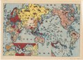
 Italy hopes war will bring new Roman Empire, 1940.jpg 3,080 × 2,405; 3.36 MB
-
 J-1903 - NARA - 131503695 (page 7).jpg 7,780 × 5,680; 22.12 MB
-
 Japan map hiroshima nagasaki az.svg 1,275 × 1,505; 86 KB
-
 Japan, the target - a pictorial Jap-map.tif 3,754 × 5,466; 58.74 MB
-
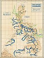
 Kaart in papier, collectie Raakvlak, BR13-TB-1.jpg 8,007 × 5,446; 6.02 MB
-
 KantokuenWikiMap.png 932 × 816; 313 KB
-
 Karte curzonlinie.png 1,000 × 855; 332 KB
-
 Leyte Landing, X Corps - 20 October, 1944.jpg 1,200 × 1,533; 274 KB
-
 Leyte Map Base - NARA - 50925966.jpg 4,625 × 6,849; 9.37 MB
-
 Locatie NDH.PNG 250 × 115; 6 KB
-
 Locatie RSI.PNG 248 × 113; 3 KB
-
 Location of the Kingdom of the South.png 449 × 456; 38 KB
-
 Los Alamos map.gif 1,000 × 1,283; 377 KB
-
 Luftangriffe auf Dresden.png 545 × 439; 80 KB
-
 MacarthursMilitaryGovernmentUnitsJan1946.png 700 × 800; 2.17 MB
-
 Major Japanese War Objectives map.jpg 1,800 × 1,380; 537 KB
-
 Map of B-29 range from Saipan.svg 804 × 676; 8.58 MB
-
 Map Of Driant.jpg 1,500 × 1,420; 381 KB
-
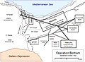 Map of Operation Bertram.jpg 1,171 × 859; 166 KB
-
 Map of Poland August 1939.png 2,333 × 2,144; 594 KB
-
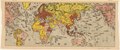
 Map of world 1943.jpg 4,128 × 2,580; 2.52 MB
-
 Map of World War II Japanese American internment camps.png 896 × 744; 105 KB
-
 Map. Battle area on the eastern front.jpg 1,067 × 1,600; 686 KB
-
 Matapan map.png 261 × 246; 16 KB
-
 Military administration Belgium Northern France.png 1,000 × 448; 142 KB
-
 New Britain WW2 map.jpg 1,200 × 554; 163 KB
-
 Newsmap Monday June 12, 1944 - map showing the Normandy landings.jpg 18,010 × 12,047; 56.55 MB
-
 Newsmap Monday June 12, 1944 showing the Normandy landings.jpg 17,872 × 13,114; 57.23 MB
-
 North Atlantic Transport Route 1945.jpg 600 × 432; 64 KB
-
 Oak Ridge area 1942.jpg 730 × 559; 116 KB
-
 Objectifs.jpg 2,126 × 1,576; 1.2 MB
-
 Offensive Aerienne des Allies contre l'Allemagne Jusqu'au 1 Fevrier 1941.jpg 12,000 × 17,961; 50.59 MB
-
 Operation frantic map.png 750 × 564; 167 KB
-
 Pacto Anti-Komintern Europa 1941.png 1,837 × 1,655; 177 KB
-
 Palau Islands relief map showing Operation Stalemate.jpg 649 × 604; 58 KB
-
 PersianGulfCommand.jpg 682 × 1,114; 251 KB
-
-
 Phillipinen map6.jpg 624 × 969; 174 KB
-
 Poland in 1939.jpg 503 × 550; 121 KB
-
 Polandball map of the World War II.png 5,547 × 2,472; 428 KB
-
 Polonyanın İşgali-1939.png 958 × 923; 145 KB
-
 Post-Operations Map - Philippine Islands - NARA - 100384981.jpg 5,988 × 6,700; 2.93 MB
-
 ProtectoradoBohemiaMoravia.PNG 698 × 415; 107 KB
-
 Reichskommissariat Ostland Infobox.png 500 × 747; 114 KB
-
 Route map 1139th Engineer Combat Group 1944 - 1945.jpg 9,350 × 6,450; 38.3 MB
-
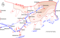
 Rschew Operation Bueffelbewegung.png 9,780 × 12,220; 38.77 MB
-
 Rückzug 19PD Juli 1943 Belgorod V3.png 1,118 × 697; 218 KB
-
 Saint Nazaire Harbour 1942 PL.png 800 × 239; 109 KB
-
 Saint Nazaire Harbour 1942.png 800 × 239; 108 KB
-
 Saw40.jpg 1,200 × 720; 142 KB
-
 Service Commands.png 800 × 552; 20 KB
-
 St. Nazer.jpg 800 × 239; 55 KB
-
 Stalins attack-plan.jpg 1,241 × 1,509; 767 KB
-
 Story of the War, 1945.jpg 7,188 × 3,136; 5.51 MB
-
 Submarine action Malacca Strai 1944.png 916 × 599; 42 KB
-
-
 The Japanese Shipping Position for 1942 - NARA - 100306985.jpg 5,141 × 4,512; 3.18 MB
-
 The Remagen Bridgehead.jpg 1,000 × 1,309; 447 KB
-
 The victory war map.tif 5,448 × 3,736; 58.26 MB
-
 Total war battle map.tif 13,215 × 5,833; 220.56 MB
-
 Trinity Test Site.jpg 1,672 × 2,208; 463 KB
-
 Triumphal Map of the 36th Infantry Division Campaigns in France, Germany, Austria.jpg 16,066 × 9,675; 29.83 MB
-
-
 Union franco-britannique.png 1,425 × 625; 49 KB
-

-
 USA-P-Papua-11 Map 11 milner Sanananda Front December 1942 .jpg 900 × 939; 171 KB
-
 USA-P-Papua-13 Map 13 milner 18-28 December 1942 .jpg 1,800 × 878; 360 KB
-
 USA-P-Papua-14 Map 14 milner18-28 December 1942 .jpg 1,200 × 1,043; 244 KB
-
 USA-P-Papua-15 Map 15 Buna milner.jpg 1,000 × 821; 210 KB
-
 USA-P-Papua-17 Map 17 milner.jpg 1,400 × 1,216; 268 KB
-

-

-
 Wehrkreise Deutsches Reich.jpg 818 × 724; 131 KB
-
 WW2 Admiralty Islands ops.jpg 2,006 × 1,403; 2.96 MB
-
 WWII-Mediterranean-v1.PNG 800 × 448; 113 KB
-
-
-
 Карта положения 326 сд на 1 – 6 мая 1945 года. ЦАМО, ф. 46, оп. 2394, д. 1489, л. 2.jpg 4,098 × 3,055; 4.58 MB
-
 Карта положения 326 сд на 13 марта 1945 года. ЦАМО, ф. 1008, оп. 1, д. 630, л. 66.jpg 1,587 × 1,733; 2.15 MB
-
 Карта положения 326 сд на 13 ноября 1943 года. ЦАМО, ф. 239, оп. 2224, д. 79, л. 2.jpg 1,470 × 1,250; 1.29 MB
-

-
 Карта положения 326 сд на 18 декабря 1943 года. ЦАМО, ф. 239, оп. 2224, д. 85, л. 2.jpg 1,905 × 2,641; 2.33 MB
-

-
 Карта положения 326 сд на 24 ноября 1943 года. ЦАМО, ф. 239, оп. 2224, д. 83, л. 2.jpg 1,662 × 1,489; 1.16 MB
-
-

-
 Карта положения 326 сд на 3 февраля 1945 года. ЦАМО, ф. 1008, оп. 1, д. 473, л. 2.jpg 2,504 × 2,511; 6.64 MB
-
 Карта положения 326 сд на 30 апреля 1945 года. ЦАМО, ф. 46, оп. 2394, д. 1489, л. 2.jpg 2,823 × 2,111; 2.54 MB
-

-
-
-

-
-

-

-

-

-

-

-

-
-

-

-
 Положение на одном из участков ЮФ 28.07.1941.jpeg 885 × 642; 350 KB
-
 Схема боёв за Васильковский узел сопротивления немцев.jpg 1,569 × 1,104; 174 KB
-
 Схема боевых порядков частей 41 сд 25.12.1943.jpg 3,500 × 2,502; 428 KB
-
 ЮЗФ 12.09.1941.jpg 805 × 559; 359 KB


.png)
.png)
.png)
_(cropped).jpg)


.jpg)
.jpg)


.jpg)


_(page_178_crop).jpg)


