Category:Maps of Buffalo, New York
Jump to navigation
Jump to search
- 100 most populous cities of the United States
- 1–25
- Austin
- Boston
- Charlotte
- Chicago
- Columbus
- Dallas
- Denver
- El Paso
- Fort Worth
- Houston
- Indianapolis
- Jacksonville
- Los Angeles
- Nashville
- New York City
- Oklahoma City
- Philadelphia
- Phoenix
- Portland
- San Antonio
- San Diego
- San Francisco
- San Jose
- Seattle
- Washington, D.C.
- 26–50
- Arlington
- Atlanta
- Bakersfield
- Colorado Springs
- Detroit
- Fresno
- Kansas City
- Las Vegas
- Long Beach
- Louisville
- Memphis
- Miami
- Minneapolis
- Oakland
- Omaha
- Raleigh
- Sacramento
- Tucson
- Tulsa
- Wichita
- 51–75
- Anaheim
- Anchorage
- Cincinnati
- Cleveland
- Corpus Christi
- Durham
- Greensboro
- Honolulu
- Irvine
- Jersey City
- Lexington
- Lincoln
- Newark
- New Orleans
- Orlando
- Pittsburgh
- Plano
- Saint Paul
- Santa Ana
- St. Louis
- Tampa
- 76–100
- Boise
- Buffalo
- Chesapeake
- Chula Vista
- Fort Wayne
- Laredo
- Lubbock
- Madison
- Norfolk
- Richmond
- Santa Clarita
- Scottsdale
- St. Petersburg
- Spokane
- Toledo
- Winston-Salem
- Cities in New York State
- ‒ Capital District
- Albany
- Cohoes
- Saratoga Springs
- Schenectady
- Troy
- ‒ Central New York
- Ithaca
- Syracuse
- ‒ New York City and Long Island
- New York City
- ‒ Finger Lakes
- Rochester
- ‒ Hudson Valley
- New Rochelle
- ‒ Mohawk Valley
- Utica
- ‒ North Country
- Plattsburgh
- ‒ Southern Tier
- Elmira
- ‒ Western New York
- Buffalo
- Niagara Falls
- North Tonawanda
Wikimedia category | |||||
| Upload media | |||||
| Instance of | |||||
|---|---|---|---|---|---|
| Category combines topics | |||||
| Buffalo | |||||
city and county seat of Erie County, New York, United States     | |||||
| Instance of |
| ||||
| Named after |
| ||||
| Location | Erie County, New York | ||||
| Located in or next to body of water | |||||
| Head of government |
| ||||
| Inception |
| ||||
| Population |
| ||||
| Area |
| ||||
| Elevation above sea level |
| ||||
| Different from | |||||
| official website | |||||
 | |||||
Subcategories
This category has the following 7 subcategories, out of 7 total.
Media in category "Maps of Buffalo, New York"
The following 63 files are in this category, out of 63 total.
-

-
 1872 Atlas view of Cooperage.jpg 1,600 × 1,200; 1.13 MB
-

-

-

-

-

-

-

-

-

-

-

-

-

-

-

-

-

-

-

-
-
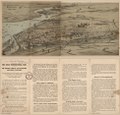
 All roads will lead to Buffalo in September. LOC 2004625832.jpg 5,266 × 5,036; 4.02 MB
-
 All roads will lead to Buffalo in September. LOC 2004625832.tif 5,266 × 5,036; 75.87 MB
-
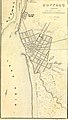
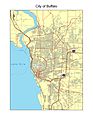
 Buffalo - map.jpg 1,654 × 1,165; 313 KB
-
 Buffalo - NARA - 26335546.jpg 4,608 × 6,169; 5.22 MB
-
 Buffalo area road network map.png 1,138 × 852; 62 KB
-
 Buffalo Canal Houses of Ill Fame.svg 1,046 × 741; 109 KB
-
 Buffalo Police Department Annual Report 1973 map.jpg 2,052 × 3,232; 1.15 MB
-
 Buffalo Street Map, 1892.jpg 2,602 × 3,971; 4.96 MB
-
 Buffalo, Double Page Plate No. 15 (Map bounded by Wabash St., Hamburg Canal, Katharine St., Buffalo River) NYPL2055431.tiff 7,015 × 5,261, 2 pages; 105.85 MB
-
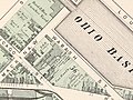
 Buffalo, Double Page Plate No. 3 (Map bounded by Exchange St., Ohio Basin Slip, Miami St., Buffalo Harbor, Main St.) NYPL2055419.tiff 7,203 × 5,402, 2 pages; 111.59 MB
-
 Buffalo, Double Page Plate No. 4 (Map bounded by Buffalo River, Louisiana St., Lake Erie) NYPL2055420.tiff 7,203 × 5,402, 2 pages; 111.59 MB
-
 Buffalo, New York 1955 Yellow Book.jpg 800 × 1,111; 294 KB
-
 BuffaloCentralTerminal-MainBldg-de.png 763 × 382; 70 KB
-
 City of Buffalo (Township) NYPL1576130.tiff 5,428 × 6,508; 101.07 MB
-
 City of Buffalo NYPL1584507.tiff 4,780 × 7,230; 98.88 MB
-
 CityOfBuffaloLandmarksHistoricDistricts December2018 v1 11x17.png 6,600 × 10,200; 5.17 MB
-
 CityOfBuffaloLandmarksHistoricDistricts March2020 v1 11x17.png 6,600 × 10,200; 5.73 MB
-
 Cooperage 1894.jpg 1,600 × 1,200; 1.62 MB
-
 Delaware Avenue Historic District.png 1,238 × 872; 589 KB
-
 Erie County New York incorporated and unincorporated areas Buffalo highlighted.svg 1,300 × 740; 2.74 MB
-

-
 Indian Church Ground-Erie County 1880 atlas-z3.JPG 1,988 × 1,504; 545 KB
-
 Indian Church Road - 1894 (Winchester Ave.) Buffalo city atlas.JPG 1,096 × 1,106; 176 KB
-
 Locals and Tourists -183 (GTWA -422) Buffalo (4686662035).jpg 6,137 × 6,137; 3.95 MB
-
 Map of Buffalo's waterfront in 1849.jpg 1,336 × 1,503; 593 KB
-

-
 Map of New York highlighting Buffalo.svg 635 × 477; 391 KB
-
 MapOfBuffalo.jpg 1,700 × 2,200; 1.89 MB
-
 Martin House complex 1916.png 999 × 793; 117 KB
-
 New York State, Plate No. 35 (Map of City of Buffalo) NYPL2056532.tiff 7,216 × 5,412, 2 pages; 112 MB
-
 NewYorkMapwithBuffalo.jpg 280 × 217; 16 KB
-
 NIE 1905 Buffalo (New York).jpg 1,588 × 1,982; 1.24 MB
-
 Official catalogue and guide book to the Pan-American exposition (1901) (14596096377).jpg 2,436 × 3,176; 1.71 MB
-
 Olmsted Buffalo Map.jpg 7,642 × 8,730; 64.5 MB
-

-
 Race and ethnicity 2010- Buffalo (5559869161) (cropped).png 1,320 × 1,320; 986 KB
-
 Race and ethnicity 2010- Buffalo (5559869161).png 3,009 × 3,009; 2.27 MB
-
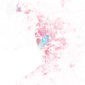 Race and ethnicity- Buffalo (5010997834).png 3,009 × 3,009; 2.42 MB
-
 System Index Map - DPLA - 90e0b95f54ef6803e594ffe128495341.jpg 3,292 × 5,100; 2.29 MB
-

-

.jpg)

_Plan_of_the_Pan-American_Exposition_to_be_held_at_Buffalo,_New_York,_May_1-Nov_1,_1901,_from_the_Digital_Commonwealth_-_commonwealth_4m90f227c.jpg)
.jpg)
.jpg)
.jpg)
.jpg)
.jpg)
.jpg)
.jpg)
.jpg)
.jpg)
.jpg)
.jpg)
.jpg)
.jpg)
.jpg)
.jpg)
.jpg)
.jpg)
_-_Erie_County_-_Buffalo_-_ED_65-1_to_880_-_NARA_-_24066800.jpg)
.jpg)


_(14597981549)_(cropped).jpg)

_Buffalo_city_atlas.JPG)
_Buffalo_(4686662035).jpg)


.jpg)
_(14596096377).jpg)

_(14574530110).jpg)
_(cropped).png)
.png)
.png)

_(14597981549).jpg)
_(14597305830).jpg)