Category:Maps of Antigua and Barbuda
Jump to navigation
Jump to search
Countries of North America: Antigua and Barbuda · The Bahamas · Barbados · Belize · Canada · Costa Rica · Cuba · Dominica · Dominican Republic · El Salvador · Grenada · Guatemala · Haiti · Honduras · Jamaica · Mexico · Nicaragua · Panama · Saint Kitts and Nevis · Saint Lucia · Saint Vincent and the Grenadines · Trinidad and Tobago‡ · United States of America‡
Other territories: Anguilla · Bermuda · British Virgin Islands · Cayman Islands · Florida Keys · Greenland · Guadeloupe · Martinique · Montserrat · Puerto Rico · Saint Barthélemy · Saint-Martin · Saint Pierre and Miquelon · Turks and Caicos Islands · United States Virgin Islands
‡: partly located in North America
Wikimedia category | |||||
| Upload media | |||||
| Instance of | |||||
|---|---|---|---|---|---|
| Category combines topics | |||||
 | |||||
Maps of Antigua and Barbuda.
Subcategories
This category has the following 10 subcategories, out of 10 total.
D
E
F
L
M
O
S
Pages in category "Maps of Antigua and Barbuda"
The following 2 pages are in this category, out of 2 total.
Media in category "Maps of Antigua and Barbuda"
The following 60 files are in this category, out of 60 total.
-
 20170904 IRMA TC-MODIFICATIONS.pdf 1,754 × 1,239; 1.07 MB
-
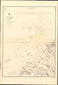 Admiralty Chart No 2065 Antigua St Johns Harbour, Published 1852, Large Corrections 1928.jpg 11,087 × 16,280; 42.77 MB
-
 Antigua and Barbuda - blank.svg 864 × 994; 349 KB
-
 Antigua and Barbuda - DPLA - 39640ae921abf2b7a46a17d3a82a4926.jpg 2,552 × 3,276; 4.49 MB
-
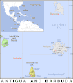
 Antigua and Barbuda - Location Map (2013) - ATG - UNOCHA.svg 254 × 254; 264 KB
-
 Antigua and Barbuda - mk.svg 864 × 994; 354 KB
-
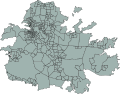
 Antigua and Barbuda administration map.png 2,000 × 2,304; 107 KB
-

-
 Antigua and Barbuda Regions map.png 1,328 × 2,500; 584 KB
-
 Antigua Enumeration District Map.svg 512 × 401; 684 KB
-
 Antigua map.jpg 1,949 × 1,354; 1.14 MB
-
 Antigua parishes blank.png 2,000 × 1,481; 25 KB
-
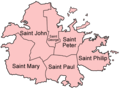 Antigua parishes english.png 500 × 370; 17 KB
-
 Antigua parishes Macedonian.png 500 × 370; 43 KB
-
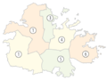 Antigua parishes numbered (color).png 565 × 424; 55 KB
-
 Antigua parishes numbered.png 200 × 148; 5 KB
-
 Antigua Prestegjeld Barbuda.png 765 × 909; 25 KB
-
 Antigua Prestegjeld Redonda.png 765 × 909; 25 KB
-
 Antigua Prestegjeld Saint George.png 765 × 909; 25 KB
-
 Antigua Prestegjeld Saint John.png 765 × 909; 25 KB
-
 Antigua Prestegjeld Saint Mary.png 765 × 909; 25 KB
-
 Antigua Prestegjeld Saint Paul.png 765 × 909; 25 KB
-
 Antigua Prestegjeld Saint Peter.png 765 × 909; 25 KB
-
 Antigua Prestegjeld Saint Philip.png 765 × 909; 25 KB
-

-

-
 Antigua-Saint George.png 100 × 74; 3 KB
-
 Antigua-Saint John.png 100 × 74; 3 KB
-
 Antigua-Saint Mary.png 100 × 74; 3 KB
-
 Antigua-Saint Paul.png 100 × 74; 3 KB
-
 Antigua-Saint Peter.png 100 × 74; 3 KB
-
 Antigua-Saint Philip.png 100 × 74; 3 KB
-
 Antigua2021OSM.png 6,608 × 4,737; 9.54 MB
-
 Antiguabarbuda parishes blank.svg 984 × 1,238; 105 KB
-
 Antiguabarbuda.jpg 984 × 1,238; 159 KB
-
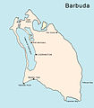 BarbudaMap.jpg 788 × 902; 178 KB
-
 Bulletin du Musée royal d'histoire naturelle de Belgique = BHL39117116.jpg 1,625 × 1,273; 153 KB
-
 Dieppe Bay in Saint Paul.pdf 4,000 × 2,250; 452 KB
-
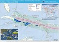
 ECDM 14092017 TC-IRMA overview.pdf 1,754 × 1,239; 853 KB
-
 ECDM 20150826 Caribbean TC.pdf 1,625 × 1,125; 653 KB
-
 ECDM 20150827 World Events.pdf 1,625 × 1,125; 469 KB
-
 ECDM 20170906 IRMA TC UPDATE.pdf 1,754 × 1,239; 805 KB
-
 ECDM 20170911 IRMA HURRICANE.pdf 1,754 × 1,239; 1,017 KB
-
 ECDM 20170918 TC-MARIA JOSE.pdf 2,479 × 1,754; 1.23 MB
-
 ECDM 20180717 Caribbean Hurricane-Season.pdf 2,479 × 1,754; 1.38 MB
-
 ECHO Antigua and Barbuda Editable A4 Portrait.pdf 1,239 × 1,754; 164 KB
-
 ECHO Antigua and Barbuda Editable A4 Portrait.png 794 × 1,123; 153 KB
-
 Enumeration districts of Antigua (grey).svg 512 × 401; 738 KB
-
 FLII Antigua.png 536 × 826; 83 KB
-
 Geologic Map Antigua Barbuda.png 634 × 433; 377 KB
-

-
 Major Division of North Coast.png 367 × 284; 50 KB
-
 Mapa de Antígua e Barbuda (OCHA).svg 254 × 254; 329 KB
-
 MapAntigua.jpg 657 × 528; 174 KB
-
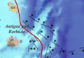
 Ne-20-11-antigua and barbuda-lesser antilles.pdf 4,425 × 3,375; 3.15 MB
-
 OSM Antigua Barbuda.png 1,775 × 2,122; 186 KB
-
 PAT - Antigua and Barbuda.gif 860 × 975; 53 KB
-
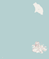
 Some Antiguan islands location.png 256 × 256; 5 KB
-
 Txu-pclmaps-oclc-22834566 j-27c.jpg 9,399 × 6,812; 8.96 MB
-
 Антыгуа і Барбуда.png 330 × 355; 10 KB


_-_ATG_-_UNOCHA.svg)


.png)


.svg)


%27_(16588898771).jpg)

.svg)


