Category:Kasteel De Mot, Ternat
Jump to navigation
Jump to search
 | |||||
| Upload media | |||||
| Instance of | |||||
|---|---|---|---|---|---|
| Location | Ternat, Arrondissement of Halle-Vilvoorde, Flemish Brabant, Flemish Region, Belgium | ||||
| Street address |
| ||||
| Heritage designation | |||||
 | |||||
|
This is a category about Beschermd erfgoed number 831
|
|
This is a category about onroerend erfgoed number 40693
|
| Address |
|
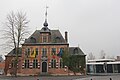
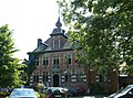
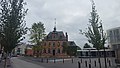
Category for the old town hall of Ternat.
Media in category "Kasteel De Mot, Ternat"
The following 7 files are in this category, out of 7 total.
-
 Kasteel De Mot 2017.jpg 5,184 × 3,456; 6.15 MB
-
 Ternat Gemeentehuisstraat 21 - 34138 - onroerenderfgoed.jpg 591 × 437; 99 KB
-
 Ternat Gemeentehuisstraat 21A - 288073 - onroerenderfgoed.jpg 1,440 × 965; 205 KB
-
 Ternat Gemeentehuisstraat 21A - 288074 - onroerenderfgoed.jpg 1,440 × 949; 304 KB
-
 Ternat-Kasteel De Mot (1).jpg 5,312 × 2,988; 4.46 MB
-
 Ternat-Kasteel De Mot (2).jpg 5,312 × 2,988; 4.57 MB
-
 Ternat-Kasteel De Mot (3).jpg 5,312 × 2,988; 5.19 MB


.jpg)
.jpg)
.jpg)