Category:Hervormde kerk (Aalburg)
Jump to navigation
Jump to search
| Object location | | View all coordinates using: OpenStreetMap |
|---|
church building in Aalburg, Netherlands  | |||||
| Upload media | |||||
| Instance of | |||||
|---|---|---|---|---|---|
| Location | Wijk en Aalburg, Altena, North Brabant, Netherlands | ||||
| Street address |
| ||||
| Located on street |
| ||||
| Has part(s) | |||||
 | |||||
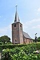
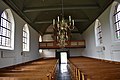
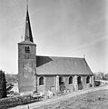
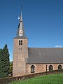
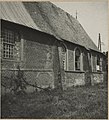
Nederlands: Hervormde kerk (voomalig Sint Trudokerk), toren 14e eeuw, schip en koor herbouwd in 1630
English: Protestant church (former St. Trudo church), tower 14th century, nave & choir rebuilt in 1630
|
This is a category about rijksmonument number 6805
|
| Address |
|
Media in category "Hervormde kerk (Aalburg)"
The following 26 files are in this category, out of 26 total.
-
 Aalburg oude Hervormde Kerk (foto 03-06-2017) (f2).jpg 4,000 × 6,000; 6.9 MB
-
 Aalburg oude Hervormde Kerk 03-06-2017 (f2, cut).jpg 3,613 × 4,890; 11.11 MB
-
 Aalburg oude Hervormde Kerk int.1.jpg 4,000 × 6,000; 5.11 MB
-
 Aalburg oude Hervormde Kerk int.2.jpg 6,000 × 4,000; 6.22 MB
-
 Aalburg oude Hervormde Kerk int.3.jpg 4,000 × 6,000; 6.26 MB
-
 Aalburg oude Hervormde Kerk int.4.jpg 6,000 × 4,000; 6.08 MB
-
 Aalburg oude Hervormde Kerk int.5.jpg 6,000 × 4,000; 6.09 MB
-
 Exterieur naar het oosten - Aalburg - 20003145 - RCE.jpg 959 × 1,200; 218 KB
-
 Exterieur naar het zuid-oosten - Aalburg - 20003147 - RCE.jpg 951 × 1,200; 195 KB
-
 Exterieur vanuit het zuid-westen - Aalburg - 20003143 - RCE.jpg 804 × 1,200; 248 KB
-
 Hervormde Gemeente Aalburg 1.jpg 4,896 × 3,672; 5.44 MB
-
 Hervormde Gemeente Aalburg 2.jpg 4,896 × 3,672; 5.43 MB
-
 Interieur naar het oosten - Aalburg - 20003149 - RCE.jpg 1,200 × 951; 161 KB
-
 Interieur naar het oosten - Aalburg - 20003150 - RCE.jpg 1,200 × 991; 209 KB
-
 Nederlands Hervormde Kerk - Aalburg - 20003144 - RCE.jpg 904 × 1,200; 189 KB
-
 Nederlands Hervormde Kerk - Wijk en Aalburg - 20003148 - RCE.jpg 1,190 × 1,200; 427 KB
-
 Noord-zijde - Aalburg - 20003146 - RCE.jpg 1,200 × 945; 307 KB
-
 Overzicht noordwestgevel met kerktoren en kerkhof - Wijk en Aalburg - 20347091 - RCE.jpg 1,200 × 1,200; 253 KB
-
 Overzicht van de westgevel, de kerktoren - Wijk en Aalburg - 20413682 - RCE.jpg 800 × 1,200; 174 KB
-
 Overzicht zuidgevel met kerktoren - Wijk en Aalburg - 20347090 - RCE.jpg 1,193 × 1,200; 301 KB
-
 Wijk en Aalburg, toren van de Nederlands Hervormde kerk RM 6805 foto2 2012-10-07 11.55.jpg 3,312 × 4,416; 4.21 MB
-

-
 Zicht op Hervormde kerk langs de dijk - Wijk en Aalburg - 20387571 - RCE.jpg 2,795 × 1,850; 2.09 MB
-
 Zicht op zuidgevel hervormde kerk met oorlogsschade - Aalburg - 20319959 - RCE.jpg 1,094 × 1,200; 269 KB
-

-

_(f2).jpg)
.jpg)


