Category:Herteveld, Maarssen
Jump to navigation
Jump to search
| Object location | | View all coordinates using: OpenStreetMap |
|---|
 | |||||
| Upload media | |||||
| Instance of | |||||
|---|---|---|---|---|---|
| Location | Maarssen, Utrecht, Netherlands | ||||
| Has part(s) | |||||
| Heritage designation |
| ||||
 | |||||
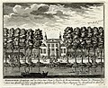
Nederlands: Herteveld, ook wel Harteveld genoemd, is een buitenplaats langs de rivier de Vecht in het Nederlandse dorp Maarssen, Straatweg 17, 17a, 19a en 19b
|
This is a category about rijksmonumentcomplex number 508200
|
Landhuis
|
This is a category about rijksmonument number 508199
|
Historische aanleg
|
This is a category about rijksmonument number 508201
|
Toegangshek
|
This is a category about rijksmonument number 508202
|
Hek
|
This is a category about rijksmonument number 508203
|
Schuurtje
|
This is a category about rijksmonument number 508204
|
Koetshuis
|
This is a category about rijksmonument number 508205
|
Tuinmanswoning
|
This is a category about rijksmonument number 508206
|
Orangerie
|
This is a category about rijksmonument number 508207
|
Lattentent
|
This is a category about rijksmonument number 520060
|
| Address |
|
Media in category "Herteveld, Maarssen"
The following 32 files are in this category, out of 32 total.
-
 Aanzicht - Maarssen - 20143962 - RCE.jpg 1,200 × 800; 271 KB
-
 Aanzicht - Maarssen - 20143963 - RCE.jpg 812 × 1,200; 303 KB
-
 Aanzicht bij gebouw ? - Maarssen - 20143961 - RCE.jpg 1,200 × 810; 322 KB
-
 Herteveld, plattegrond park door J.v.Broekhuizen - Maarssen - 20143591 - RCE.jpg 1,200 × 954; 204 KB
-
 Herteveld-Maarssen (5).jpg 1,000 × 665; 592 KB
-

-
-

-
 Huis Herteveld, Amsterdamsestraatweg, voorgevel - Maarssen - 20143592 - RCE.jpg 1,200 × 804; 253 KB
-
 Huis Herteveld, bijgebouw - Maarssen - 20143593 - RCE.jpg 1,200 × 801; 327 KB
-
 Huis Herteveld, detailstoegangshek - Maarssen - 20143595 - RCE.jpg 1,200 × 1,197; 312 KB
-
 Huis Herteveld, hek - Maarssen - 20143594 - RCE.jpg 1,200 × 821; 298 KB
-
 Interieur Grote Zaal, detail dessus de porte - Maarssen - 20349805 - RCE.jpg 1,200 × 1,200; 163 KB
-
 Interieur Grote Zaal, detail dessus de porte - Maarssen - 20349806 - RCE.jpg 1,200 × 1,172; 179 KB
-
 Interieur Grote Zaal, doorzicht naar gang - Maarssen - 20349804 - RCE.jpg 1,200 × 1,200; 180 KB
-
 Interieur zaal, detail stucwerk - Maarssen - 20340066 - RCE.jpg 1,197 × 1,200; 250 KB
-

-

-

-
 Interieur, overzicht Grote Zaal - Maarssen - 20349807 - RCE.jpg 1,200 × 1,200; 221 KB
-
 Interieur, overzicht Grote Zaal - Maarssen - 20349808 - RCE.jpg 1,200 × 1,200; 224 KB
-

-
 Maarssen 508202 hek Herteveld.JPG 3,072 × 2,304; 1.21 MB
-
 Rijksmomument.jpg 4,774 × 3,162; 2.11 MB
-
 Rijksmonument-26450-Herteveld-koetshuis.jpg 3,686 × 2,765; 3.64 MB
-
 Rijksmonument-508199-Herteveld.jpg 3,686 × 2,371; 2.27 MB
-
 Toegangshek - Maarssen - 20275695 - RCE.jpg 1,200 × 1,200; 442 KB
-
 Toegangshek - Maarssen - 20275696 - RCE.jpg 1,197 × 1,200; 480 KB
-
 Toegangshek, binnenzijde - Maarssen - 20275697 - RCE.jpg 1,200 × 1,200; 440 KB
-
 Toegangshek, buitenzijde - Maarssen - 20275694 - RCE.jpg 1,192 × 1,200; 382 KB
-
 Tuinbeeld van buitenplaats Herteveld te Maarssen.jpg 2,448 × 3,264; 3.39 MB
-
 Voorgevel woonhuis - Maarssen - 20143960 - RCE.jpg 1,200 × 813; 257 KB


.jpg)


