Category:Ewijckshoeve
Jump to navigation
Jump to search
| Object location | | View all coordinates using: OpenStreetMap |
|---|
 | |||||
| Upload media | |||||
| Instance of | |||||
|---|---|---|---|---|---|
| Location | Den Dolder, Zeist, Utrecht, Netherlands | ||||
| Street address |
| ||||
| Located on street | |||||
| Architectural style | |||||
| Has part(s) | |||||
| Heritage designation |
| ||||
 | |||||
|
This is a category about rijksmonumentcomplex number 529893
|
Landhuis:
|
This is a category about rijksmonument number 529894
|
Historische aanleg:
|
This is a category about rijksmonument number 529895
|
Koetshuis:
|
This is a category about rijksmonument number 529896
|
Duivenhok:
|
This is a category about rijksmonument number 529897
|
| Address |
|
Media in category "Ewijckshoeve"
The following 24 files are in this category, out of 24 total.
-
 Ewijckshoeve - 1.jpg 4,032 × 3,024; 7.84 MB
-
 Ewijckshoeve - 2.jpg 3,024 × 4,032; 8.32 MB
-
 Ewijckshoeve 238.JPG 3,264 × 2,448; 1.91 MB
-
 Gevel - Den Dolder - 20369473 - RCE.jpg 1,200 × 801; 209 KB
-
 Gevels - Den Dolder - 20369474 - RCE.jpg 1,200 × 802; 235 KB
-
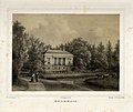 HUA-135858-Gezicht op het huis Ewijkshoeve te Zeist met het bijbehorende park.jpg 4,087 × 3,449; 4.76 MB
-

-
 INTERIEUR, BADKAMER (ART DECO) DEUR - Den Dolder - 20280117 - RCE.jpg 1,189 × 1,200; 246 KB
-

-
 INTERIEUR, BADKAMER (ART DECO) KAST EN VERWARMING - Den Dolder - 20280116 - RCE.jpg 1,196 × 1,200; 260 KB
-
 INTERIEUR, BADKAMER (ART DECO) LAMP - Den Dolder - 20280113 - RCE.jpg 1,193 × 1,200; 193 KB
-
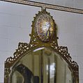 INTERIEUR, BADKAMER (ART DECO) LAMP BOVEN SPIEGEL - Den Dolder - 20280114 - RCE.jpg 1,192 × 1,200; 213 KB
-
 INTERIEUR, BADKAMER (ART DECO) LIGBAD - Den Dolder - 20280118 - RCE.jpg 1,197 × 1,200; 302 KB
-
 INTERIEUR, BADKAMER (ART DECO) OVERZICHT - Den Dolder - 20280111 - RCE.jpg 1,196 × 1,200; 280 KB
-
 INTERIEUR, BADKAMER (ART DECO) OVERZICHT - Den Dolder - 20280115 - RCE.jpg 1,193 × 1,200; 254 KB
-
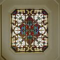 INTERIEUR, BADKAMER (ART DECO) PLAFOND, RAAM - Den Dolder - 20280122 - RCE.jpg 1,200 × 1,198; 271 KB
-

-
 INTERIEUR, BADKAMER (ART DECO) WAND, TEGELS - Den Dolder - 20280121 - RCE.jpg 1,192 × 1,200; 202 KB
-
 INTERIEUR, BADKAMER (ART DECO), WASTAFEL - Den Dolder - 20280112 - RCE.jpg 1,193 × 1,200; 272 KB
-
 Koetshuis Ewijkshoeve.jpg 1,024 × 768; 190 KB
-
 Overzicht achtergevel - Den Dolder - 20027241 - RCE.jpg 1,200 × 804; 197 KB
-
 Overzicht achterzijde - Den Dolder - 20221701 - RCE.jpg 1,200 × 962; 255 KB
-
 Park Ewijkshoeve.jpg 1,024 × 768; 157 KB
-
 RM529894 Ewijckshoeve.jpg 2,592 × 1,944; 1.94 MB


_DEUR_-_Den_Dolder_-_20280117_-_RCE.jpg)
_DEUR,_DETAIL_(glas-in-lood)_-_Den_Dolder_-_20280119_-_RCE.jpg)
_KAST_EN_VERWARMING_-_Den_Dolder_-_20280116_-_RCE.jpg)
_LAMP_-_Den_Dolder_-_20280113_-_RCE.jpg)
_LAMP_BOVEN_SPIEGEL_-_Den_Dolder_-_20280114_-_RCE.jpg)
_LIGBAD_-_Den_Dolder_-_20280118_-_RCE.jpg)
_OVERZICHT_-_Den_Dolder_-_20280111_-_RCE.jpg)
_OVERZICHT_-_Den_Dolder_-_20280115_-_RCE.jpg)
_PLAFOND,_RAAM_-_Den_Dolder_-_20280122_-_RCE.jpg)
_TEGELWAND,_DETAIL_(MARMER)_-_Den_Dolder_-_20280120_-_RCE.jpg)
_WAND,_TEGELS_-_Den_Dolder_-_20280121_-_RCE.jpg)
,_WASTAFEL_-_Den_Dolder_-_20280112_-_RCE.jpg)


