Category:Electricity pylons in the East Riding of Yorkshire
Jump to navigation
Jump to search
Ceremonial counties of England: Bedfordshire · Berkshire · Buckinghamshire · Cambridgeshire · Cheshire · Cornwall · Cumbria · Derbyshire · Devon · Dorset · Durham · East Riding of Yorkshire · East Sussex · Essex · Gloucestershire · Greater London · Greater Manchester · Hampshire · Herefordshire · Hertfordshire · Isle of Wight · Kent · Lancashire · Leicestershire · Lincolnshire · Merseyside · Norfolk · North Yorkshire · Northamptonshire · Northumberland · Nottinghamshire · Oxfordshire · Rutland · Shropshire · Somerset · South Yorkshire · Staffordshire · Suffolk · Surrey · Tyne and Wear · Warwickshire · West Midlands · West Sussex · West Yorkshire · Wiltshire · Worcestershire
City-counties:
Former historic counties:
Other former counties:
City-counties:
Former historic counties:
Other former counties:
Main category: Electricity pylons
Subcategories
This category has only the following subcategory.
K
Media in category "Electricity pylons in the East Riding of Yorkshire"
The following 200 files are in this category, out of 656 total.
(previous page) (next page)-
 (Private) road to Woo Dale - geograph.org.uk - 721832.jpg 640 × 480; 182 KB
-
 2010 Wilberfoss Birker Lane Field Head Junction - geograph.org.uk - 1726273.jpg 1,744 × 1,308; 856 KB
-
 A bridleway near Loftsome Bridge (geograph 2509970).jpg 800 × 600; 225 KB
-
 A brief moment of quiet on the A1079 (geograph 6106349).jpg 1,024 × 768; 105 KB
-
 A farm bridge over Barmston Drain near Dunswell (geograph 2205866).jpg 800 × 600; 263 KB
-
 A Field beside Westfield Road, Eppleworth - geograph.org.uk - 723728.jpg 640 × 383; 152 KB
-
 A field off Raich Carter Way, East Yorkshire (geograph 3238267).jpg 800 × 600; 100 KB
-
 A Harrow - geograph.org.uk - 253389.jpg 638 × 480; 101 KB
-
 A Heavy Plant has crossed the road - geograph.org.uk - 723779.jpg 640 × 427; 143 KB
-
 A Minor Drain - geograph.org.uk - 251986.jpg 640 × 480; 102 KB
-
 A minor road to the south of Wressle (geograph 2277201).jpg 800 × 600; 197 KB
-
 A path leading to Beverley Road (geograph 3675914).jpg 800 × 600; 150 KB
-
 A Pit Stop For Tractors - geograph.org.uk - 251555.jpg 640 × 480; 106 KB
-
 A Stone Carr Field - geograph.org.uk - 603555.jpg 640 × 480; 90 KB
-
 A View From The Big Bridleway - geograph.org.uk - 251238.jpg 640 × 480; 105 KB
-
 A walk along the River Hull No14 (geograph 1998155).jpg 800 × 600; 266 KB
-
 A walk along the River Hull No15 (geograph 1998159).jpg 800 × 600; 213 KB
-
 A walk along the River Hull No5 (geograph 1998035).jpg 800 × 600; 261 KB
-
 A walk along the River Hull No7 (geograph 1998056).jpg 800 × 600; 291 KB
-
 A Wolds way Trig Point - geograph.org.uk - 930940.jpg 480 × 640; 127 KB
-
 A Wolds' Farm Track - geograph.org.uk - 1278318.jpg 640 × 480; 123 KB
-
 A Yorkshire Wolds farm - geograph.org.uk - 174362.jpg 640 × 373; 68 KB
-
 A1079 at power lines east of Wilberfoss (geograph 6824618).jpg 1,024 × 723; 184 KB
-
 A1079 Beverley Bypass from Park Lane (geograph 4399383).jpg 1,600 × 1,062; 955 KB
-
 A1079 beverley eastbound enh.png 300 × 225; 120 KB
-
 A1079 beverley eastbound.jpg 1,695 × 1,225; 252 KB
-
 A1079 beverley westbound enh.png 300 × 225; 115 KB
-
 A1079 beverley westbound.jpg 2,048 × 1,536; 479 KB
-
 A1079, Beverley Bypass (geograph 6361408).jpg 800 × 600; 67 KB
-
 A163 At Harlthorpe.jpg 640 × 480; 102 KB
-
 A164 near West Ella - geograph.org.uk - 87905.jpg 640 × 480; 122 KB
-
 A164 towards Beverley (geograph 6361405).jpg 800 × 600; 90 KB
-
 Access road from Foss Farm toward Birker Lane (geograph 4878335).jpg 4,608 × 3,456; 3.33 MB
-
 Access to Intake Farm (geograph 5322439).jpg 1,024 × 768; 163 KB
-
 Across A63 to Moorstile Balk - geograph.org.uk - 758036.jpg 640 × 356; 152 KB
-
 Across the field to Snaith - geograph.org.uk - 1093222.jpg 640 × 480; 57 KB
-
 Adlingfleet Drain - geograph.org.uk - 509896.jpg 443 × 640; 124 KB
-
 After the harvest^ - geograph.org.uk - 1383745.jpg 640 × 480; 61 KB
-

-
 Allerthorpe Common Nature Reserve - geograph.org.uk - 9221.jpg 640 × 480; 93 KB
-
 Anonymous Drain East of Hull - geograph.org.uk - 713916.jpg 640 × 427; 198 KB
-
 Another Pit For Tractors - geograph.org.uk - 251652.jpg 640 × 480; 103 KB
-
 Another Wet Square - geograph.org.uk - 11721.jpg 640 × 480; 37 KB
-
 Approaching Beverley Parks Crossing (geograph 4448818).jpg 1,280 × 954; 852 KB
-
 Approaching Poplar Farm (geograph 4448549).jpg 1,280 × 954; 1.09 MB
-
 Ashcombe Road, Kingswood, Hull (geograph 3675751).jpg 800 × 600; 144 KB
-
 Asselby Marsh (geograph 5885585).jpg 1,024 × 768; 170 KB
-
 Autumn in Wilberfoss - geograph.org.uk - 1574636.jpg 640 × 480; 278 KB
-
 Back on track (geograph 1981614).jpg 800 × 600; 161 KB
-
 Bales in field - geograph.org.uk - 540741.jpg 640 × 480; 99 KB
-
 Bales near Preston - geograph.org.uk - 953507.jpg 640 × 570; 218 KB
-
 Barge moored on the River Hull at Wawne (geograph 5449625).jpg 2,304 × 1,728; 1.28 MB
-
 Barmby Cutting - geograph.org.uk - 576980.jpg 640 × 480; 143 KB
-
 Barn at Poplar Farm, East Yorkshire (geograph 4399239).jpg 1,600 × 1,062; 680 KB
-
 Barns at Poplar Farm, East Yorkshire (geograph 4399234).jpg 1,600 × 1,062; 1.38 MB
-
 Behind Field Head - geograph.org.uk - 737412.jpg 1,744 × 1,308; 1.48 MB
-
 Bellasize Drain - geograph.org.uk - 939378.jpg 640 × 480; 117 KB
-
 Bellasize Drain, west of Blacktoft - geograph.org.uk - 860401.jpg 640 × 322; 162 KB
-

-
 Between the lines (geograph 4448517).jpg 1,280 × 939; 1.07 MB
-
 Between Wilberfoss and Fangfoss - geograph.org.uk - 211201.jpg 640 × 479; 46 KB
-
 Beverley & Barmston Drain at Dunswell (geograph 5235661).jpg 1,200 × 799; 449 KB
-
 Beverley & Barmston Drain at Dunswell (geograph 5235694).jpg 1,200 × 799; 346 KB
-
 Beverley 20 on Parks Lane (geograph 5101378).jpg 1,600 × 1,065; 671 KB
-
 Beverley 20 towards Bentley (geograph 5101427).jpg 1,600 × 1,065; 900 KB
-
 Beverley 20-High Hunsley Circuit - geograph.org.uk - 126617.jpg 640 × 480; 95 KB
-
 Beverley 5616 Substation on Long Lane (geograph 4399952).jpg 1,600 × 1,062; 833 KB
-
 Beverley and Barmston Drain - geograph.org.uk - 707578.jpg 640 × 427; 132 KB
-
 Beverley bypass (geograph 3209660).jpg 640 × 427; 63 KB
-
 Beverley Bypass - geograph.org.uk - 63726.jpg 640 × 480; 113 KB
-

-
 Beverley Parks Crossing - geograph.org.uk - 49273.jpg 640 × 480; 96 KB
-
 Beverley Parks level crossing (geograph 6116048).jpg 1,024 × 768; 141 KB
-
 Beverley Rd, Skidby - panoramio.jpg 1,200 × 798; 440 KB
-
 Beverley Road, Dunswell (geograph 5235469).jpg 1,200 × 799; 304 KB
-
 Beverley Road, Dunswell (geograph 6104300).jpg 800 × 494; 78 KB
-
 Beverley sisters - geograph.org.uk - 629385.jpg 640 × 472; 184 KB
-
 Big sky, big pylon (geograph 5933175).jpg 1,024 × 654; 87 KB
-
 Bird box on Skidby Carr Lane (geograph 5236344).jpg 1,200 × 799; 449 KB
-
 Birker Lane (geograph 6494456).jpg 1,024 × 768; 223 KB
-
 Blacktoft Jetty - geograph.org.uk - 635693.jpg 640 × 452; 80 KB
-
 Blacktoft Sands RSPB Reserve - geograph.org.uk - 1742115.jpg 640 × 480; 61 KB
-
 Boxing Day Hunt - geograph.org.uk - 97631.jpg 640 × 480; 101 KB
-
 Brantingham - geograph.org.uk - 570946.jpg 640 × 468; 100 KB
-
 Bridge on Hull and Barnsley Railway between Willerby and Little Weighton.jpg 1,024 × 768; 332 KB
-
 Bridge over A1079 - geograph.org.uk - 836596.jpg 640 × 369; 136 KB
-
 Bridleway and Power Lines - geograph.org.uk - 126598.jpg 640 × 480; 111 KB
-
 Bridleway near Model Farm - geograph.org.uk - 1774072.jpg 640 × 480; 116 KB
-
 Bridleway towards Cottingham - geograph.org.uk - 1774085.jpg 640 × 480; 66 KB
-
 Bridleway-Farm Track - geograph.org.uk - 126622.jpg 640 × 480; 101 KB
-
 Broad Path - geograph.org.uk - 129119.jpg 640 × 480; 98 KB
-
 Broadmarsh well - geograph.org.uk - 1235071.jpg 640 × 480; 59 KB
-
 Bullocks at Model Farm (geograph 4451604).jpg 1,024 × 768; 171 KB
-
 Bund off North Moor Lane (geograph 4404031).jpg 1,024 × 768; 219 KB
-
 Burn Park - geograph.org.uk - 233176.jpg 640 × 471; 91 KB
-
 Burn Park Cottages - geograph.org.uk - 583189.jpg 640 × 433; 163 KB
-
 Burn Park Cottages - geograph.org.uk - 661108.jpg 640 × 480; 60 KB
-
 Burriers Lane - geograph.org.uk - 1344307.jpg 640 × 480; 45 KB
-
 Burton Rakes - geograph.org.uk - 99928.jpg 640 × 480; 158 KB
-
 Bus stop on Beverley Road (A1174) (geograph 4349874).jpg 640 × 480; 67 KB
-
 Bus stop on the A1174, Dunswell (geograph 4353978).jpg 640 × 480; 50 KB
-
 Bus stop with bench, Wawne (geograph 4353862).jpg 640 × 480; 82 KB
-
 Byway near Swine - geograph.org.uk - 32500.jpg 640 × 480; 113 KB
-
 Cables over a ditch - geograph.org.uk - 1387112.jpg 640 × 480; 162 KB
-
 Castlehill Bridge - geograph.org.uk - 553836.jpg 640 × 480; 82 KB
-
 Cattle north of Skidby - geograph.org.uk - 233565.jpg 640 × 480; 90 KB
-
 Cave Crossing, Broomfleet - geograph.org.uk - 446861.jpg 640 × 461; 86 KB
-
 Coach and Horses Dunswell.jpg 640 × 389; 188 KB
-
 Common Lane - geograph.org.uk - 170651.jpg 640 × 480; 108 KB
-
 Common Lane Bridge (geograph 5677100).jpg 1,024 × 768; 181 KB
-
 Common Lane Bridge, near Wawne - geograph.org.uk - 1164607.jpg 640 × 458; 186 KB
-
 Common Lane, near Wawne - geograph.org.uk - 1164611.jpg 467 × 640; 173 KB
-
 Coppleflat Lane (geograph 6436411).jpg 1,024 × 768; 182 KB
-
 Coppleflat Lane, Walkington - geograph.org.uk - 699245.jpg 640 × 385; 50 KB
-
 Copse on Westwood (geograph 2881640).jpg 3,648 × 2,736; 4.7 MB
-
 Cormorants near Tophill Low (geograph 6148311).jpg 1,024 × 768; 195 KB
-
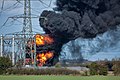 Cottingham sub station fire -2535 - panoramio.jpg 1,200 × 799; 270 KB
-
 Country Colours - geograph.org.uk - 182470.jpg 640 × 480; 81 KB
-
 Cow Lane towards Garthorpe - geograph.org.uk - 1235053.jpg 640 × 480; 55 KB
-
 Crawberry Dale - geograph.org.uk - 481133.jpg 640 × 416; 72 KB
-
 Crawberry Dale's rotting bales - geograph.org.uk - 634401.jpg 640 × 421; 174 KB
-
 Creyke Beck 400kv Substation near Cottingham (geograph 4398399).jpg 1,600 × 1,062; 1.03 MB
-
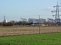 Creyke Beck Electricity Substation - geograph.org.uk - 668658.jpg 640 × 480; 79 KB
-
 Creyke Beck Fire.jpg 2,448 × 3,264; 1.17 MB
-
 Creyke Beck Substation (geograph 6456722).jpg 1,024 × 768; 158 KB
-
 Creyke Beck substation from St. Marys church tower (geograph 1877250).jpg 1,600 × 1,067; 281 KB
-
 Crop field, Foxholme (geograph 4353846).jpg 640 × 480; 55 KB
-
 CutlerCreykeBeck.jpg 1,000 × 1,333; 1.14 MB
-
 Cycle path beside Beverley Road (A1079) (geograph 4351216).jpg 640 × 480; 78 KB
-
 Cycle Path near the A164 - geograph.org.uk - 1733534.jpg 800 × 600; 145 KB
-
 Dancing Lane, Swine - geograph.org.uk - 652217.jpg 640 × 392; 66 KB
-
 Dead tree trio near Rowley - geograph.org.uk - 674228.jpg 483 × 640; 198 KB
-
 Demolished Bridge - geograph.org.uk - 63155.jpg 640 × 480; 62 KB
-
 Derelict glasshouses - geograph.org.uk - 596777.jpg 640 × 543; 183 KB
-
 Descending to Autherd Drain (geograph 4446665).jpg 1,280 × 960; 1.18 MB
-
 Drain near Faxfleet - geograph.org.uk - 806922.jpg 480 × 640; 210 KB
-
 Drain near Wilfholme Landing - geograph.org.uk - 1142041.jpg 640 × 375; 196 KB
-
 Drain near Wressle (geograph 3939559).jpg 1,024 × 768; 124 KB
-
 Drainage ditch near Brind Leys Farm (geograph 2324945).jpg 1,600 × 1,200; 646 KB
-
 Drove Lane (geograph 4441629).jpg 1,024 × 768; 209 KB
-
 Drove Lane off Ferry Road, Wawne (geograph 5483829).jpg 1,600 × 1,078; 534 KB
-
 Drove Lane off Ferry Road, Wawne (geograph 5483833).jpg 1,600 × 1,065; 451 KB
-
 Dunswell Lane at TA0629135141 - geograph.org.uk - 49268.jpg 640 × 480; 62 KB
-
 Dunswell Lane chicane - geograph.org.uk - 603214.jpg 640 × 628; 204 KB
-
 Dunswell lane, max algae - panoramio.jpg 1,000 × 711; 372 KB
-
 Dunswell Road near North farm - geograph.org.uk - 1774160.jpg 640 × 480; 53 KB
-
 Dunswell Road north of Cottingham (geograph 5236662).jpg 1,200 × 799; 323 KB
-
 Dunswell Road towards Cottingham (geograph 5236405).jpg 1,200 × 799; 330 KB
-
 Dunswell roundabout - geograph.org.uk - 603072.jpg 640 × 402; 148 KB
-
 Dyke and Bridge - geograph.org.uk - 334619.jpg 640 × 480; 106 KB
-
 East of Ellerker - geograph.org.uk - 114788.jpg 640 × 480; 186 KB
-
 Eastbound on Beverley Bypass, A1079 towards Hull (geograph 2231498).jpg 800 × 600; 183 KB
-
 Eggborough Power Station - geograph.org.uk - 189709.jpg 640 × 480; 66 KB
-
 Electricity and water - geograph.org.uk - 1333609.jpg 640 × 329; 32 KB
-
 Electricity Distribution Terminal - geograph.org.uk - 390271.jpg 640 × 413; 81 KB
-
 Electricity Pylon - geograph.org.uk - 1604522.jpg 640 × 480; 32 KB
-
 Electricity Pylon, Tongue Lane - geograph.org.uk - 1603558.jpg 516 × 640; 46 KB
-
 Electricity Pylons - geograph.org.uk - 1603380.jpg 640 × 480; 36 KB
-
 Electricity Pylons - geograph.org.uk - 1603672.jpg 487 × 640; 38 KB
-
 Electricity pylons on Watton Carrs (geograph 6148340).jpg 1,024 × 768; 131 KB
-
 Electricity Sub Station - geograph.org.uk - 126640.jpg 640 × 419; 75 KB
-
 Electricity Sub Station - geograph.org.uk - 999350.jpg 640 × 480; 107 KB
-

-
 Electricity Substation, Creyke Beck - geograph.org.uk - 391943.jpg 640 × 448; 73 KB
-

-
 Elloughton.jpg 640 × 480; 82 KB
-
 End of Brind Lane (geograph 3567999).jpg 640 × 427; 86 KB
-
 Entering the East Riding of Yorkshire (geograph 3238229).jpg 800 × 600; 119 KB
-
 Extec Conveyor Machine (geograph 5236461).jpg 1,200 × 799; 340 KB
-
 Fairholme Double Bridge (geograph 4977756).jpg 4,608 × 3,456; 3.96 MB
-
 Fallow Farmland - geograph.org.uk - 308343.jpg 640 × 480; 84 KB
-
 Farm buildings near Dunswell, East Yorkshire (geograph 3745339).jpg 1,024 × 681; 215 KB
-
 Farm buildings, White House Farm, Dunswell (geograph 6104303).jpg 640 × 467; 69 KB
-
 Farm Entrance - geograph.org.uk - 308340.jpg 640 × 480; 72 KB
-
 Farm Road - geograph.org.uk - 174361.jpg 640 × 480; 103 KB
-
 Farm Track East of Kelwell Farm - geograph.org.uk - 1528116.jpg 640 × 480; 73 KB
-
 Farm Track, Stone Carr - geograph.org.uk - 1552158.jpg 640 × 480; 76 KB
-
 Farmland and pylon, Hull Bank Farm (geograph 4352712).jpg 640 × 480; 49 KB
-
 Farmland beside Ling Lane (geograph 6447891).jpg 1,024 × 683; 599 KB
-
 Farmland near Bentley - geograph.org.uk - 1733522.jpg 800 × 600; 80 KB
-
 Farmland near Brind Leys Farm (geograph 2324946).jpg 1,600 × 1,200; 506 KB
-
 Farmland near Carlam Hill Farm - geograph.org.uk - 1528183.jpg 640 × 480; 59 KB
-

-
 Farmland near Kirk Ella Grange - geograph.org.uk - 1733613.jpg 800 × 600; 126 KB
-
 Farmland near Model Farm - geograph.org.uk - 1774063.jpg 640 × 480; 74 KB
-
 Farmland near Poplar Farm - geograph.org.uk - 1774087.jpg 640 × 482; 79 KB
-
 Farmland near Swine - geograph.org.uk - 1528146.jpg 640 × 480; 80 KB
-
 Farmland near Swine - geograph.org.uk - 32487.jpg 640 × 480; 95 KB
-
 Farmland near Wawne - geograph.org.uk - 34873.jpg 640 × 480; 112 KB
-
 Farmland off Beverley Road - geograph.org.uk - 1733563.jpg 800 × 600; 55 KB
-
 Farmland off Riplingham Road - geograph.org.uk - 1733554.jpg 800 × 600; 87 KB
-
 Farmland off Shepherd Lane - geograph.org.uk - 1774048.jpg 640 × 480; 58 KB
-
 Farmland off Swanland Dale - geograph.org.uk - 1733616.jpg 800 × 600; 122 KB
-
 Farmland south of Wressle (geograph 2324924).jpg 1,600 × 1,200; 478 KB
-
 Farmland View - geograph.org.uk - 270482.jpg 640 × 480; 116 KB
-
 Farmland View - geograph.org.uk - 382524.jpg 640 × 480; 95 KB
-
 Farmland View - geograph.org.uk - 382526.jpg 640 × 420; 54 KB
-
 Farmland View - geograph.org.uk - 382985.jpg 640 × 480; 114 KB
-
 Farmland, Dunswell - geograph.org.uk - 1527913.jpg 640 × 480; 50 KB
-
 Farmland, Intake farm (geograph 2348202).jpg 640 × 480; 86 KB
_road_to_Woo_Dale_-_geograph.org.uk_-_721832.jpg)

.jpg)
.jpg)
.jpg)

.jpg)


.jpg)
.jpg)


.jpg)
.jpg)
.jpg)
.jpg)


.jpg)
.jpg)


.jpg)


.jpg)
.jpg)
.jpg)


.jpg)
.jpg)
.jpg)
.jpg)

.jpg)


.jpg)

.jpg)
.jpg)


.jpg)
.jpg)

.jpg)
.jpg)
.jpg)
.jpg)

.jpg)

.jpg)

_-_geograph.org.uk_-_392047.jpg)

.jpg)

.jpg)
.jpg)

.jpg)
.jpg)
.jpg)


.jpg)
.jpg)


_(geograph_4349874).jpg)
.jpg)
.jpg)


.jpg)


.jpg)

.jpg)
.jpg)


.jpg)


.jpg)
.jpg)
.jpg)

_(geograph_4351216).jpg)


.jpg)


.jpg)
.jpg)
.jpg)
.jpg)
.jpg)


.jpg)
.jpg)


.jpg)


.jpg)


.jpg)
.jpg)
.jpg)
.jpg)

.jpg)
.jpg)


.jpg)
.jpg)

.jpg)


.jpg)


.jpg)