Category:Dongecentrale
Jump to navigation
Jump to search
| Object location | | View all coordinates using: OpenStreetMap |
|---|
 | |||||
| Upload media | |||||
| Instance of |
| ||||
|---|---|---|---|---|---|
| Named after | |||||
| Location | Geertruidenberg, North Brabant, Netherlands | ||||
| Located in or next to body of water | |||||
| Street address |
| ||||
| Located on street |
| ||||
| Owned by |
| ||||
| Has part(s) | |||||
| Date of official opening |
| ||||
 | |||||
|
This is a category about rijksmonumentcomplex number 520037
|
Ketelhuis:
|
This is a category about rijksmonument number 520038
|
Filtergebouw:
|
This is a category about rijksmonument number 520039
|
Transformatorgebouw:
|
This is a category about rijksmonument number 525804
|
| Address |
|
Media in category "Dongecentrale"
The following 16 files are in this category, out of 16 total.
-
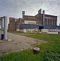
 Dongecentrale.jpg 2,592 × 1,944; 1.41 MB
-
 Exterieur, centrale gebouwen - Geertruidenberg - 20321444 - RCE.jpg 1,196 × 1,200; 266 KB
-
 Exterieur, overzicht achterkant hoofdgebouw - Geertruidenberg - 20321448 - RCE.jpg 1,188 × 1,200; 285 KB
-
 Exterieur, overzicht binnenterrein - Geertruidenberg - 20321443 - RCE.jpg 1,188 × 1,200; 276 KB
-
 Exterieur, overzicht centralecomplex - Geertruidenberg - 20321435 - RCE.jpg 1,195 × 1,200; 262 KB
-
 Exterieur, overzicht toegang tot terrein - Geertruidenberg - 20321442 - RCE.jpg 1,199 × 1,200; 300 KB
-
 Exterieur, overzicht voorzijde - Geertruidenberg - 20321441 - RCE.jpg 1,199 × 1,200; 299 KB
-

-
 Exterieur, voor- en zijgevel hoofdgebouw - Geertruidenberg - 20321446 - RCE.jpg 1,192 × 1,200; 255 KB
-
 Exterieur, zijgevel hoofdgebouw - Geertruidenberg - 20321445 - RCE.jpg 1,187 × 1,200; 289 KB
-

-

-

-
 Interieur hoofdgebouw, hal met installatie - Geertruidenberg - 20321452 - RCE.jpg 1,190 × 1,200; 265 KB
-
 Interieur hoofdgebouw, overzicht hal met machines - Geertruidenberg - 20321451 - RCE.jpg 1,195 × 1,200; 287 KB
-


