Category:Coendersborg (Nuis)
Jump to navigation
Jump to search
| Object location | | View all coordinates using: OpenStreetMap |
|---|
 | |||||
| Upload media | |||||
| Instance of |
| ||||
|---|---|---|---|---|---|
| Part of | |||||
| Location | Nuis, Westerkwartier, Groningen, Netherlands | ||||
| Street address |
| ||||
| Heritage designation |
| ||||
 | |||||
Nederlands: Coendersborg, Nuis
|
This is a category about rijksmonumentcomplex number 528898
|
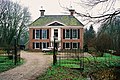
Landhuis
|
This is a category about rijksmonument number 528899
|
Tuin- en parkaanleg
|
This is a category about rijksmonument number 528900
|
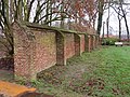
Tuinmuur
|
This is a category about rijksmonument number 528901
|
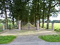
Toegangshek oprijlaan
|
This is a category about rijksmonument number 528902
|
Toegangshek borg
|
This is a category about rijksmonument number 530400
|
| Address |
|
Media in category "Coendersborg (Nuis)"
The following 25 files are in this category, out of 25 total.
-
 Coendersborg .jpeg 3,024 × 4,032; 5.84 MB
-
 Coendersborg, historische tuin- en parkaanleg.JPG 4,608 × 3,456; 3.21 MB
-
 Coendersborg, Oudeweg 15, Nuis.JPG 3,861 × 2,902; 2.34 MB
-
 Coendersborg.JPG 3,264 × 2,448; 1.92 MB
-
 Coendersborg09 19 48 144000.jpeg 3,024 × 4,032; 6.04 MB
-
 Coendersborg09 19 59 192000.jpeg 4,032 × 3,024; 3.79 MB
-
 Coendersborg1.JPG 1,838 × 1,228; 1.04 MB
-
 Fietspad door het landgoed van de Coenderborg - panoramio.jpg 2,048 × 1,536; 638 KB
-
 Middeleeuwse tuinmuur ten oosten van de Coendersborg te Nuis..JPG 4,000 × 3,000; 5.6 MB
-
 Museum 't Rieuw (Oudeweg 17) naast Coendersborg II.jpg 1,632 × 918; 442 KB
-
 Museum 't Rieuw (Oudeweg 17) naast Coendersborg.jpg 1,632 × 918; 554 KB
-
 Nuis Coendersborg borg landgoed 01 03 49 872000.jpeg 4,032 × 3,024; 3.81 MB
-
 Nuis Coendersborg borg landgoed 01 03 57 822000.jpeg 4,032 × 3,024; 4.73 MB
-
 Nuis Coendersborg borg landgoed 01 04 06 081000.jpeg 4,032 × 3,024; 4.45 MB
-
 Nuis Coendersborg borg landgoed 01 04 16 404000.jpeg 4,032 × 3,024; 6.63 MB
-
 Nuis Coendersborg borg landgoed 01 04 26 969000.jpeg 4,032 × 3,024; 5.22 MB
-
 Nuis Coendersborg borg landgoed 01 05 45 396000.jpeg 3,024 × 4,032; 4.54 MB
-
 Nuis Coendersborg borg landgoed 01 05 55 840000.jpeg 3,024 × 4,032; 6.15 MB
-
 Nuis Coendersborg borg landgoed.jpeg 4,032 × 3,024; 4.31 MB
-
 Nuis Hek Coendersborch.JPG 4,000 × 3,000; 4.8 MB
-
 Nuis, Nederland May 21, 2021 06-23-07 PM.jpeg 4,032 × 3,024; 4.86 MB
-

-
 Toeganshek van de Coendersborg..JPG 2,034 × 1,285; 514 KB
-
 Voor- en zijgevel - Nuis - 20170235 - RCE.jpg 1,200 × 812; 238 KB
-
 Voorgevel en linker zijgevel van het herenhuis - Nuis - 20364152 - RCE.jpg 1,200 × 950; 305 KB


_naast_Coendersborg_II.jpg)
_naast_Coendersborg.jpg)


