Category:Castle D'Erp
Jump to navigation
Jump to search
| Object location | | View all coordinates using: OpenStreetMap |
|---|
castle in Baarlo, Netherlands  | |||||
| Upload media | |||||
| Instance of | |||||
|---|---|---|---|---|---|
| Part of |
| ||||
| Location | Baarlo, Maasbree, Limburg, Netherlands | ||||
| Street address |
| ||||
| Located on street |
| ||||
| Heritage designation |
| ||||
 | |||||
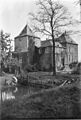
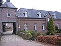
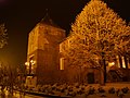
Nederlands: Kasteel d'Erp, ook genaamd De Borcht, in Baarlo, Limburg, Nederland
English: Castle D'Erp, or "Huys Baerlo", in Baarlo, The Netherlands
|
This is a category about rijksmonumentcomplex number 526639
|
Kasteel:
|
This is a category about rijksmonument number 526637
|
Tuin- en parkaanleg:
|
This is a category about rijksmonument number 526640
|
Poortgebouw:
|
This is a category about rijksmonument number 526641
|
Economiegebouwen:
|
This is a category about rijksmonument number 526642
|
Wasplaats:
|
This is a category about rijksmonument number 530016
|
Former:
|
This is a category about rijksmonument number 26528
|
| Address |
|
Media in category "Castle D'Erp"
The following 109 files are in this category, out of 109 total.
-
 Aanzicht - Baarlo - 20026884 - RCE.jpg 809 × 1,200; 238 KB
-
 Baarlo - Boerderij bij Kasteel d'Erp.JPG 2,048 × 1,536; 957 KB
-
 Baarlo.JPG 3,264 × 2,448; 1.73 MB
-
 Baarlo.jpg 1,000 × 665; 744 KB
-
 Begane grond blik in het trappehuis - Baarlo - 20026945 - RCE.jpg 955 × 1,200; 150 KB
-

-
 Begane grond detail plafond zaal Z.O.vleugel - Baarlo - 20026924 - RCE.jpg 1,192 × 1,200; 381 KB
-
 Begane grond detail plafond zuid-oost vleugel - Baarlo - 20026925 - RCE.jpg 1,195 × 1,200; 425 KB
-
 Begane grond detail plafond, zaal zuid-oost vleugel - Baarlo - 20026923 - RCE.jpg 1,192 × 1,200; 345 KB
-

-
 Begane grond kamertje rechts naast entreehal - Baarlo - 20026950 - RCE.jpg 1,200 × 1,200; 255 KB
-
 Begane grond naar het zuid-oosten - Baarlo - 20026951 - RCE.jpg 1,192 × 1,200; 306 KB
-
 Begane grond noord-oost hoekkamer - Baarlo - 20026949 - RCE.jpg 1,192 × 1,200; 312 KB
-
 Begane grond poorttoren naar het noord-westen - Baarlo - 20026952 - RCE.jpg 1,195 × 1,200; 224 KB
-
 Begane grond trap naar boven - Baarlo - 20026948 - RCE.jpg 1,185 × 1,200; 293 KB
-
 Begane grond zaal zuid-oost vleugel - Baarlo - 20026939 - RCE.jpg 1,200 × 960; 191 KB
-
 Begane grond zuid-oost hoekkamer - Baarlo - 20026943 - RCE.jpg 1,200 × 969; 200 KB
-
 Binnenplaats naar het noord-oost - Baarlo - 20026917 - RCE.jpg 959 × 1,200; 238 KB
-
 Binnenplaats naar het zuid-west - Baarlo - 20026919 - RCE.jpg 1,190 × 1,200; 299 KB
-
 Binnenplaats oostgevel - Baarlo - 20026963 - RCE.jpg 1,200 × 807; 226 KB
-
 Binnenplaats oostgevel - Baarlo - 20026964 - RCE.jpg 1,200 × 808; 238 KB
-
 Binnenplaats voet van de poorttoren - Baarlo - 20026920 - RCE.jpg 1,190 × 1,200; 356 KB
-
 Binnenplaats, zuidgevel - Baarlo - 20026962 - RCE.jpg 1,200 × 800; 216 KB
-

-

-

-
 Blik in de verdieping van de poorttoren - Baarlo - 20026969 - RCE.jpg 788 × 1,200; 211 KB
-
 Brug voor ingang - Baarlo - 20026995 - RCE.jpg 1,200 × 802; 241 KB
-
 Castle Baarlo.jpg 3,072 × 2,048; 2.97 MB
-
 D'Erp Baarlo.JPG 3,264 × 2,448; 3.92 MB
-
 D'Erp Baarlo2.JPG 3,264 × 2,448; 3.79 MB
-
 Detail houtconstructie met jaartal - Baarlo - 20026972 - RCE.jpg 788 × 1,200; 242 KB
-
 Detail zuid-oost gevel - Baarlo - 20026911 - RCE.jpg 1,015 × 1,200; 348 KB
-
 Detail zuid-west gevel met ingang - Baarlo - 20026908 - RCE.jpg 958 × 1,200; 389 KB
-
 Diverse details - Baarlo - 20026981 - RCE.jpg 1,200 × 788; 207 KB
-
 Diverse details - Baarlo - 20026982 - RCE.jpg 1,200 × 788; 185 KB
-
 Diverse details - Baarlo - 20026983 - RCE.jpg 788 × 1,200; 312 KB
-
 Diverse details - Baarlo - 20026984 - RCE.jpg 788 × 1,200; 319 KB
-
 Diverse details - Baarlo - 20026985 - RCE.jpg 788 × 1,200; 224 KB
-
 Diverse details - Baarlo - 20026986 - RCE.jpg 788 × 1,200; 213 KB
-
 Diverse details - Baarlo - 20026987 - RCE.jpg 788 × 1,200; 221 KB
-
 Diverse details - Baarlo - 20026988 - RCE.jpg 788 × 1,200; 204 KB
-
 Diverse details - Baarlo - 20026989 - RCE.jpg 805 × 1,200; 267 KB
-
 Diverse details - Baarlo - 20026990 - RCE.jpg 804 × 1,200; 251 KB
-
 Diverse details - Baarlo - 20026991 - RCE.jpg 806 × 1,200; 272 KB
-
 Entreehal - Baarlo - 20026938 - RCE.jpg 1,200 × 954; 226 KB
-
 Entreehal - Baarlo - 20026944 - RCE.jpg 944 × 1,200; 194 KB
-
 Exterieur gezien uit het noorden - Baarlo - 20026913 - RCE.jpg 1,200 × 953; 316 KB
-
 Exterieur noord-oost gevel - Baarlo - 20026905 - RCE.jpg 1,200 × 956; 265 KB
-
 Exterieur OVERZICHT LINKER ZIJGEVEL - Baarlo - 20260486 - RCE.jpg 798 × 1,200; 206 KB
-
 Exterieur OVERZICHT VOORGEVEL - Baarlo - 20260485 - RCE.jpg 1,200 × 782; 222 KB
-
 Exterieur uit het zuid-west met poorttoren - Baarlo - 20026907 - RCE.jpg 962 × 1,200; 346 KB
-
 Exterieur zuid-oost gevel - Baarlo - 20026904 - RCE.jpg 1,200 × 963; 323 KB
-
 Exterieur zuid-west gevel - Baarlo - 20026903 - RCE.jpg 1,200 × 959; 296 KB
-
 Exterieur zuid-west gevel - Baarlo - 20026906 - RCE.jpg 1,200 × 961; 332 KB
-
 Gebintstijl met jaartal 1598 nr. 66-4 - Baarlo - 20507213 - RCE.jpg 605 × 888; 117 KB
-
 Gedeelte van de zuid-oost gevel - Baarlo - 20026914 - RCE.jpg 1,008 × 1,200; 340 KB
-
 Gezien uit het zuid-west exterieur - Baarlo - 20026902 - RCE.jpg 1,200 × 958; 324 KB
-

-
 Holt-d'Erp "de Borcht" vanuit het zuid-oosten - Baarlo - 20026887 - RCE.jpg 1,200 × 903; 249 KB
-
 Holt-d'Erp "de Borcht" vanuit het zuid-westen - Baarlo - 20026888 - RCE.jpg 1,200 × 856; 267 KB
-
 Holt-d'Erp, exterieur naar het zuid-westen - Baarlo - 20026890 - RCE.jpg 1,200 × 948; 294 KB
-
 Holt-d'Erp, plafond - Baarlo - 20026897 - RCE.jpg 1,200 × 860; 153 KB
-
 Holt-d'Erp, scheurvorming begane grond - Baarlo - 20026893 - RCE.jpg 947 × 1,200; 222 KB
-
 Holt-d'Erp, scheurvorming torenkamer - Baarlo - 20026892 - RCE.jpg 951 × 1,200; 168 KB
-
 Holt-d'Erp, schoorsteenmantels - Baarlo - 20026898 - RCE.jpg 1,200 × 838; 219 KB
-
 Holt-d'Erp, schoorsteenmantels - Baarlo - 20026899 - RCE.jpg 1,200 × 849; 232 KB
-
 Holt-d'Erp, toren 1e verdieping scheurvorm - Baarlo - 20026894 - RCE.jpg 956 × 1,200; 166 KB
-
 Holt-d'Erp, toren 1e verdieping scheurvorm - Baarlo - 20026895 - RCE.jpg 939 × 1,200; 154 KB
-
 Kasteel d'Erp, Baarlo.JPG 4,320 × 2,432; 4.67 MB
-
 Kasteel d'Erp, ook genaamd De Borcht.jpg 3,627 × 2,341; 7.01 MB
-
 KnupTajiri met Kasteel d'Erp.JPG 3,264 × 2,448; 2.92 MB
-
 Markt, wasplaats - Baarlo - 20027073 - RCE.jpg 1,200 × 810; 323 KB
-
 NIMH - 2155 001066 - Aerial photograph of Baarlo, The Netherlands.jpg 3,520 × 2,353; 1.73 MB
-
 Noord-oost hoek van de binnenplaats - Baarlo - 20026965 - RCE.jpg 800 × 1,200; 180 KB
-
 Noord-west zijde poorttoren - Baarlo - 20026910 - RCE.jpg 959 × 1,200; 355 KB
-

-
 Noordvleugel van de voorhof nr. 66-5 - Baarlo - 20507212 - RCE.jpg 624 × 888; 144 KB
-
 Overzicht - Baarlo - 20026885 - RCE.jpg 1,200 × 894; 245 KB
-
 Overzicht - Baarlo - 20026996 - RCE.jpg 1,200 × 801; 266 KB
-
 Overzicht achterzijde - Baarlo - 20026886 - RCE.jpg 1,200 × 894; 274 KB
-
 Overzicht uit het noorden met poorttoren - Baarlo - 20026912 - RCE.jpg 950 × 1,200; 267 KB
-
 Poorttoren 1e verdieping naar het noord-westen - Baarlo - 20026946 - RCE.jpg 1,195 × 1,200; 219 KB
-
 Poorttoren 1e verdieping trap naar 2e verdieping - Baarlo - 20026947 - RCE.jpg 1,183 × 1,200; 261 KB
-
 Poorttoren 2e verdieping - Baarlo - 20026922 - RCE.jpg 1,195 × 1,200; 344 KB
-
 Poorttoren uit het noord-west - Baarlo - 20026909 - RCE.jpg 955 × 1,200; 303 KB
-
 Poorttoren, binnenplaats zijde - Baarlo - 20026918 - RCE.jpg 1,192 × 1,200; 330 KB
-
 Rechterzijgevel - Baarlo - 20026994 - RCE.jpg 1,200 × 806; 232 KB
-

-

-
 Toegangspoort voorburcht binnenplaatszijde - Baarlo - 20026916 - RCE.jpg 1,200 × 949; 327 KB
-
 Toegangspoort voorburcht buitenzijde - Baarlo - 20026915 - RCE.jpg 943 × 1,200; 371 KB
-
 Verdieping blik in het trappehuis - Baarlo - 20026921 - RCE.jpg 1,190 × 1,200; 219 KB
-

-

-
 Verdieping kamertje in zuid-west vleugel - Baarlo - 20026927 - RCE.jpg 1,200 × 1,195; 357 KB
-
 Verdieping kamertje in zuid-west vleugel hoge gedeelte - Baarlo - 20026926 - RCE.jpg 1,200 × 1,192; 302 KB
-
 Verdieping zuid-oost hoekkamer gezien naar het oosten - Baarlo - 20026935 - RCE.jpg 1,185 × 1,200; 280 KB
-
 Voor en rechterzijgevel - Baarlo - 20026993 - RCE.jpg 1,200 × 796; 234 KB
-
 Voorgevel - Baarlo - 20026992 - RCE.jpg 1,200 × 804; 193 KB
-

-
 Zuid-oost hoek van de binnenplaats - Baarlo - 20026970 - RCE.jpg 788 × 1,200; 230 KB
-

-

-

-

-
 Zuid-oost hoekkamer verdieping oostmuur - Baarlo - 20026978 - RCE.jpg 1,200 × 788; 247 KB
-
 Zuid-west hoekkamer begane grond - Baarlo - 20026941 - RCE.jpg 1,200 × 958; 197 KB
-
 Zuidgevel binnenplaats - Baarlo - 20026980 - RCE.jpg 1,200 × 788; 242 KB


