Category:Boekesteyn
Jump to navigation
Jump to search
| Upload media | |||||
| Instance of | |||||
|---|---|---|---|---|---|
| Location |
| ||||
| Has part(s) | |||||
| Heritage designation |
| ||||
 | |||||
|
This is a category about rijksmonument number 520831
|
Boerderij 't Huys Brambergen:
|
This is a category about rijksmonument number 17363
|
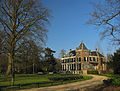
Landhuis:
|
This is a category about rijksmonument number 520832
|
Historische aanleg:
|
This is a category about rijksmonument number 520833
|
Blok van vijf dienstwoningen:
|
This is a category about rijksmonument number 520834
|
Tuinmanswoning:
|
This is a category about rijksmonument number 520835
|
Koetshuis annex koetsierswoning:
|
This is a category about rijksmonument number 520836
|
| Address |
|
| Object location | | View all coordinates using: OpenStreetMap |
|---|
Subcategories
This category has the following 4 subcategories, out of 4 total.
B
- Boerderij 't Huys Brambergen (6 F)
K
- Koetshuis, Boekesteyn (6 F)
N
T
- Tuinmanswoning, Boekesteyn (6 F)
Media in category "Boekesteyn"
The following 24 files are in this category, out of 24 total.
-
 's-Graveland - Boekesteyn RM520832.JPG 4,572 × 2,375; 1.23 MB
-
 's-Graveland - Boekesteyn Tuin RM520833.JPG 4,608 × 2,350; 1.16 MB
-
 Boekesteijn.jpg 871 × 631; 205 KB
-
 Boekestein, Noordereind - 's-Graveland - 20084498 - RCE.jpg 1,200 × 965; 317 KB
-
 Boekesteyn 2008.jpg 3,648 × 2,048; 1.69 MB
-
 Huis Boekestein, interieur - 's-Graveland - 20084499 - RCE.jpg 809 × 1,200; 166 KB
-
 Klok met de naam Kemper erin gegraveerd - 's-Graveland - 20398951 - RCE.jpg 882 × 1,200; 199 KB
-
 Noordereinde ? Huis Boeckestein - 's-Graveland - 20084226 - RCE.jpg 1,193 × 1,200; 408 KB
-
 Noordereinde ? Huis Boeckestein - 's-Graveland - 20084227 - RCE.jpg 1,200 × 1,197; 327 KB
-
 S-Graveland, Boekesteyn hist aanleg park RM520833 (1).jpg 1,600 × 1,200; 1.68 MB
-
 S-Graveland, Boekesteyn hist aanleg park RM520833 (2).jpg 1,600 × 1,200; 1.85 MB
-
 S-Graveland, Boekesteyn hist aanleg park RM520833 (3).jpg 1,200 × 1,600; 2.41 MB
-
 S-Graveland, Boekesteyn landhuis RM520832 (1).jpg 3,687 × 2,788; 3.97 MB
-
 S-Graveland, Boekesteyn landhuis RM520832 (10).jpg 1,600 × 1,200; 1.83 MB
-
 S-Graveland, Boekesteyn landhuis RM520832 (11).jpg 1,611 × 1,214; 1.58 MB
-
 S-Graveland, Boekesteyn landhuis RM520832 (12).jpg 1,200 × 1,600; 1.48 MB
-
 S-Graveland, Boekesteyn landhuis RM520832 (2).jpg 1,600 × 1,200; 1.88 MB
-
 S-Graveland, Boekesteyn landhuis RM520832 (3).jpg 1,621 × 1,228; 2.09 MB
-
 S-Graveland, Boekesteyn landhuis RM520832 (4).jpg 1,652 × 1,271; 2.61 MB
-
 S-Graveland, Boekesteyn landhuis RM520832 (5).jpg 1,600 × 1,200; 1.87 MB
-
 S-Graveland, Boekesteyn landhuis RM520832 (6).jpg 1,622 × 1,229; 1.82 MB
-
 S-Graveland, Boekesteyn landhuis RM520832 (7).jpg 1,642 × 1,255; 2.1 MB
-
 S-Graveland, Boekesteyn landhuis RM520832 (8).jpg 1,600 × 1,200; 1.73 MB
-
 S-Graveland, Boekesteyn landhuis RM520832 (9).jpg 1,611 × 1,214; 1.89 MB


.jpg)
.jpg)
.jpg)
.jpg)
.jpg)
.jpg)
.jpg)
.jpg)
.jpg)
.jpg)
.jpg)
.jpg)
.jpg)
.jpg)
.jpg)