Atlas de Wit 1698
Jump to navigation
Jump to search
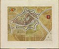
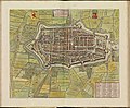
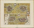
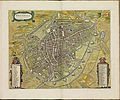
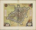
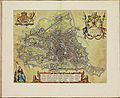
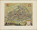
The Atlas De Wit (also: Town and city atlas De Wit) is unique, historic atlas by Dutch cartographer Frederick De Wit containing 158 city maps, city views and engravings from the northern and southern Netherlands (the current Netherlands, Belgium and French-Flanders).
More background information and city index (in Dutch): http://www.kb.nl/themas/atlassen/stedenatlas-de-wit
| Frederik de Wit: Atlas De Wit 1698, collection KB
|
|||||||||||||||||||||
|---|---|---|---|---|---|---|---|---|---|---|---|---|---|---|---|---|---|---|---|---|---|
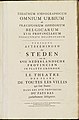
| Title |
French: Le theatre des plans de toutes les villes qui sont situéez dans les XVII Provinces du Pays Bas parfaictement déseignéez Atlas De Wit 1698, collection KB |
 | |||||||||||||||||||
| Publisher | |||||||||||||||||||||
| Printer | |||||||||||||||||||||
| Object type |
city map atlas / version, edition or translation |
||||||||||||||||||||
| Language |
Middle Dutch |
||||||||||||||||||||
| Date |
circa |
||||||||||||||||||||
| Publication date |
circa |
||||||||||||||||||||
| Collection |
|
||||||||||||||||||||
| Accession number |
KW 1046 B 16 (Koninklijke Bibliotheek) |
||||||||||||||||||||
| References | |||||||||||||||||||||
| Authority file | |||||||||||||||||||||

-
 Voorplat
 -
 Schutblad voor
 -
 001r
001r -
 001v
001v -
 002r
002r -
 002v
002v -
 003r
003r -
 pl001 - Nijmegen
 -
 pl002 - Zutphen
 -
 pl003 - Harderwijk
 -
 pl004 - Arnhem
 -
 pl005 - Groenlo
 -
 pl006 - Doesburg
 -
 pl007 - Tiel
 -
 pl008 - Zaltbommel
 -
 pl009 - Wageningen
 -
 pl010 - Culemborg
 -
 pl011 - Schenkenschans
 -
 pl012 - Gelre (Geldern)
 -
 pl013 - Roermond
 -
 pl014 - Dordrecht
 -
 pl015 - Haarlem
 -
 pl016 - Delft
 -
 pl017 - Leiden
 -
 pl017a - Leiden, Stadhuis - Pieterskerk - St. Pancraskerk - De burcht
 -
 pl017a - Leiden, Stadhuis
 -
 pl017a - Leiden, Pieterskerk
 -
 pl017a - Leiden, St. Pancraskerk
 -
 pl017a - Leiden, De burcht
 -
 pl017b - Leiden, Nieuw Gefondeerde Kerk of Waardkerk (niet gebouwd) - Academiegebouw - Kruythoff (hortus) - Marekerk - Lakenhal
 -
 pl017b - Leiden, Nieuw Gefondeerde Kerk of Waardkerk (niet gebouwd)
 -
 pl017b - Leiden, Academiegebouw
 -
 pl017b - Leiden, Kruythoff (hortus)
 -
 pl017b - Leiden, Lakenhal
 -
 pl017b - Leiden, Marekerk
 -
 pl018 - Amsterdam
 -
 pl018a - Amsterdam, Dam
 -
 pl018b - Amsterdam, Stadhuis
 -
 pl018c - Amsterdam, profiel (Joan de Ram)
 -
 pl018d - Amsterdam, Oude Kerk
 -
 pl018e - Amsterdam, Zuiderkerk
 -
 pl018f - Amsterdam, profiel
 -
 pl019 - Gouda
 -
 pl020 - Rotterdam
 -
 pl021 - Schiedam
 -
 pl022 - Schoonhoven
 -
 pl023 - Gorkum
 -
 pl024 - Brielle
 -
 pl025 - Alkmaar
 -
 pl026 - Hoorn
 -
 pl027 - Enkhuizen
 -
 pl028 - Edam
 -
 pl029 - Purmerend
 -
 pl030 - Monnickendam
 -
 pl031 - Medemblik
 -
 pl032 - Woerden
 -
 pl033 - Weesp
 -
 pl034 - Heusden
 -
 pl035-'s - Gravenhage
 -
 pl036 - Middelburg
 -
 pl037 - Zierikzee
 -
 pl038 - Goes
 -
 pl039 - Tholen
 -
 pl040 - Vlissingen
 -
 pl041 - Veere
 -
 pl042 - Arnemuiden
 -
 pl043 - Rammekens
 -
 pl044 - Utrecht
 -
 pl044a - Utrecht, profiel
 -
 pl044b - Utrecht, Stadhuis
 -
 pl045 - Amersfoort
 -
 pl045a - Amersfoort, profiel
 -
 pl046 - Rhenen
 -
 pl047 - Wijk bij Duurstede
 -
 pl048 - Montfoort
 -
 pl049 - Leeuwarden
 -
 pl050 - Bolswaart
 -
 pl051 - Franeker
 -
 pl052 - Sneek
 -
 pl053 - Dokkum
 -
 pl054 - Harlingen
 -
 pl055 - Stavoren
 -
 pl056 - Workum
 -
 pl057 - Deventer
 -
 pl058 - Kampen
 -
 pl059 - Zwolle
 -
 pl060 - Hasselt
 -
 pl061 - Vollenhoven
 -
 pl062 - Steenwijk
 -
 pl063 - Oldenzaal
 -
 pl064 - Blokzijl
 -
 pl065 - Zwartsluis
 -
 pl066 - Groningen
 -
 pl067 - Coevorden
 -
 pl068 - Delfzijl
 -
 pl069 - Bourtange
 -
 pl070 - Brussel
 -
 pl071 - Antwerpen
 -
 pl071a - Antwerpen, Kasteel
 -
 pl071b - Antwerpen, Oostershuis
 -
 pl071c - Antwerpen, Stadhuis
 -
 pl072 - Mechelen
 -
 pl073 - Tienen
 -
 pl074 - Lier
 -
 pl075 - Leuven
 -
 pl076-'s - Hertogenbosch
 -
 pl077 - Breda
 -
 pl078 - Grave
 -
 pl079 - Bergen op Zoom
 -
 pl080 - 't Fort van Ordam
 -
 pl081 - Maastricht
 -
 pl082 - Bergen in henegouwen
 -
 pl083 - Mariembourg
 -
 pl084 - Kamerijk (Cambrai)
 -
 pl085 - Atrecht (Arras)
 -
 pl086 - Saint Omer
 -
 pl087 - Hesdin
 -
 pl088 - Gent
 -
 pl089 - Kortrijk
 -
 pl090 - Nieuwpoort
 -
 pl091 - Brugge
 -
 pl092 - Damme
 -
 pl093 - Oostende
 -
 pl094 - Grevelingen (Gravelines)
 -
 pl095-Sint - Winoksbergen
 -
 pl096 - Ieper
 -
 pl097 - Rijssel (Lille)
 -
 pl098 - Rijssel (Lille)
 -
 pl099 - Douai
 -
 pl100 - Doornik
 -
 pl101 - Valenciennes
 -
 pl102 - Geraardsbergen
 -
 pl103 - Veurne
 -
 pl104 - Brouckburg (Bourbourg)
 -
 pl105 - Bailleul
 -
 pl106 - Aalst
 -
 pl107 - Armentiers (Armentières)
 -
 pl108 - Diksmuide
 -
 pl109 - Plassendaal
 -
 pl110 - Diedenhove (Thionville)
 -
 pl111 - Stevenswaard
 -
 pl112 - Luik (Liège)
 -
 Schutblad achter
 -
 Achterplat


-KB_PPN_145205088.jpg)


-KB_PPN_145205088.jpg)
.jpg)

.jpg)


-KB_PPN_145205088.jpg)


-KB_PPN_145205088.jpg)
-KB_PPN_145205088.jpg)


-KB_PPN_145205088.jpg)


-KB_PPN_145205088.jpg)


-KB_PPN_145205088.jpg)


-KB_PPN_145205088.jpg)


-KB_PPN_145205088.jpg)

-KB_PPN_145205088.jpg)

