File:VerkehrsnetzMuenchen2006.png
Jump to navigation
Jump to search
Size of this preview: 800 × 566 pixels. Other resolutions: 320 × 226 pixels | 640 × 453 pixels | 1,024 × 725 pixels | 1,280 × 906 pixels | 2,271 × 1,607 pixels.
Original file (2,271 × 1,607 pixels, file size: 576 KB, MIME type: image/png)
Captions
Captions
Add a one-line explanation of what this file represents
|

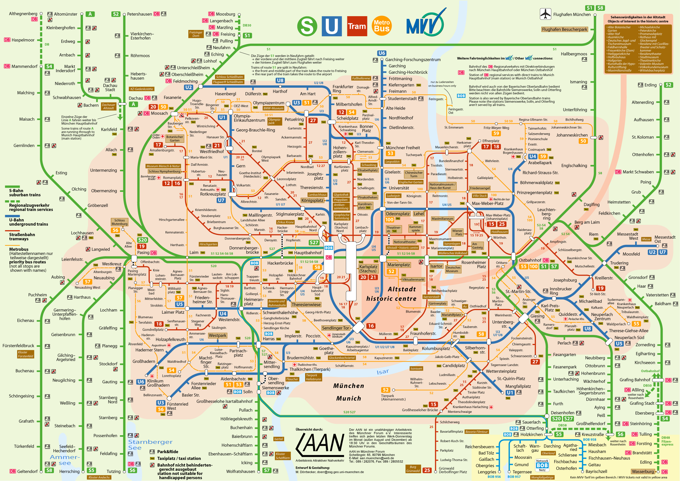
This image was selected as picture of the day on Wikimedia Commons for 26 February 2009. It was captioned as follows: English: Munich's Public Transport Network Other languages:
Afrikaans: Die Münchense spoornetplan van 2006, intussen verouderd Bahasa Indonesia: Jaringan Transportasi Umum München Dansk: Trafikplan over Münchens offentlige transport i 2006. Deutsch: Zwischenzeitlich veralteter Liniennetzplan Münchens aus dem Jahr 2006, aktuelle Version hier English: Munich's Public Transport Network Français : Plan légèrement périmé (2006) du réseau de transports en commun de Münich. Galego: Plano da rede de transporte público da cidade de Múnic Nederlands: Lijnennetkaart van het openbaar vervoersnetwerk van München uit 2006 (actuele versie hier) Polski: Schemat komunikacji miejskiej w Monachium w Niemczech. Português: Sistema de transportes públicos de Munique Română: Rețeaua publică de transport din München Suomi: Münchenin julkisen liikenteen verkosto. Türkçe: Münih'in toplu taşıma sistemi Українська: Схема громадського транспорту в місті Мюнхені (Баварія, Німеччина) станом на 2006 рік. Чинну на 2008 рік див. тут. 한국어: 뮌헨 근교 공공 교통 노선도 (2006년) 日本語: ミュンヘン近郊公共交通路線図(2006年) 中文: 慕尼黑公共交通图 中文(繁體): 德國慕尼黑公共交通圖 |
| Description |
Deutsch: Verkehrsnetz München 2006
English: Munich's Public Transport Network 2006
Français : Réseau des transports publics de Munich en 2006 |
||
| Date | |||
| Source | Self made (logos used: DB, MVV, S-Bahn, U-Bahn, Tram, Bus, Taxi, Baustelle, Rollstuhl, P+R; some are modified) | ||
| Author | Maximilian Dörrbecker (Chumwa) | ||
| Permission (Reusing this file) |
I, the copyright holder of this work, hereby publish it under the following license: This file is licensed under the Creative Commons Attribution-Share Alike 2.5 Generic license.
|
||
| Other versions |
Weitere Münchner ÖPNV-Pläne:
|


File history
Click on a date/time to view the file as it appeared at that time.
| Date/Time | Thumbnail | Dimensions | User | Comment | |
|---|---|---|---|---|---|
| current | 19:45, 20 July 2015 | | 2,271 × 1,607 (576 KB) | Cmdrjameson (talk | contribs) | Compressed with pngout. Reduced by 422kB (42% decrease). |
| 06:42, 4 December 2006 |  | 2,271 × 1,607 (999 KB) | Chumwa (talk | contribs) | Die U6 fährt jetzt bis Garching-Forschungsgelände | |
| 08:05, 8 July 2006 |  | 2,271 × 1,607 (1.04 MB) | Chumwa (talk | contribs) | *'''Description:''' Verkehrsnetz München 2006 *'''Source:''' Maximilian Dörrbecker {{GFDL}} Category:ÖPNVCategory:Public transportCategory:Rapid transitCategory:S-BahnCategory:U-BahnCategory:StraßenbahnCategory:MetroBus[[ |
You cannot overwrite this file.
File usage on Commons
More than 100 pages use this file. The following list shows the first 100 pages that use this file only. A full list is available.
- München
- München U-Bahn
- User:Chumwa/Gallery
- User:Chumwa/OtherVersions - Karten München
- User:Chumwa/OtherVersions - ÖPNV-Karten München
- User:Dschwen/FP2006
- Commons:Featured picture candidates/Image:VerkehrsnetzMuenchen2006.png
- Commons:Featured picture candidates/Log/December2006
- Commons:Featured pictures/Non-photographic media/Maps
- Commons:Featured pictures/chronological/2006-B
- Commons:Picture of the Year/2006/gallery
- Commons:Picture of the Year/2006/gallery0
- Commons:Picture of the Year/2006/gallery large
- Commons:Potd/2009-02 (da)
- Commons:Potd/2009-02 (de)
- Commons:Potd/2009-02 (eo)
- Commons:Potd/2009-02 (nl)
- Commons:Potd/2009-02 (pt)
- Commons:Potd/2009-02 (tr)
- Commons talk:Featured picture candidates/Archive candidate list
- File:Administrative boundaries of the borough of Solln in Munich.png
- File:Gleis 93.jpg
- File:Gleis 96.jpg
- File:Gleis 97b.jpg
- File:Karte Flaucher München.png
- File:Karte München Landnutzung.png
- File:Karte München Schwarzplan.png
- File:Karte München ÖPNV.png
- File:Karte München Übersichtsplan.png
- File:Karte Viktualienmarkt München.png
- File:Karte der Burgfrieden von München.png
- File:Karte der Denkmalschutzensembles in München.jpg
- File:Karte der Gemarkungen in München.png
- File:Karte der Gemarkungen und Stadtbezirke in München.png
- File:Karte der Ortsbezeichnungen in München.png
- File:Karte der Parkstadt Bogenhausen in München.png
- File:Karte der S-Bahn München.png
- File:Karte der Stadtbezirke in München.png
- File:Karte der Stadtbezirke in München in der bis 1992 gültigen Gliederung.png
- File:Karte der Stadtbezirksteile in München.png
- File:Karte der geplanten U9-Spange der U-Bahn München.png
- File:Linienband U-Bahn München.png
- File:Metrobusnetzplan München.png
- File:MuenchenSBahnMitSuedring.png
- File:MuenchenSBahnMitZweitemTunnel.png
- File:München - Basiskarte farbig.pdf
- File:München - Basiskarte farbig.png
- File:München - Basiskarte farbig - mit Nachbargemeinden.jpg
- File:München - Basiskarte grau.pdf
- File:München - Basiskarte grau.png
- File:München - Stadtbezirke (Karte).png
- File:Schnellbahnplan München.png
- File:SchnellbahnschemaplanMuenchenTopographisch2006.png
- File:SchnellbahnschemaplanMuenchenTopographisch2007.png
- File:Stadterweiterungen München.png
- File:StrassenbahnSchemaplanMuenchen1997.png
- File:StrassenbahnnetzMuenchen1964.jpg
- File:Straßenbahnnetzplan München.png
- File:Streckennetz der S-Bahn München.jpg
- File:U-Bahn-Plan München.png
- File:UBahnLinienbandMuenchen2006.png
- File:UBahnLinienbandMuenchen2007.png
- File:UBahnMuenchen Stammstrecke3.png
- File:UBahnSchemaplanMuenchenTopographisch2006.png
- File:UBahnSchemaplanMuenchenTopographisch2007.png
- File:UBahnSchemaplanMuenchenTopographisch2008.png
- File:VerkehrsnetzMuenchen2006.png
- File:VerkehrsnetzMuenchen2007.png
- File:VerkehrsnetzMünchen2005.png
- File:Verkehrsnetz München.png
- File:Verkehrsnetz München 2007.png
- File:Westpark München (Karte).png
- File:Westpark München zur IGA 1983 (Karte).png
- Template:Potd/2009-02
- Template:Potd/2009-02-26
- Template:Potd/2009-02-26 (af)
- Template:Potd/2009-02-26 (cs)
- Template:Potd/2009-02-26 (da)
- Template:Potd/2009-02-26 (de)
- Template:Potd/2009-02-26 (en)
- Template:Potd/2009-02-26 (es)
- Template:Potd/2009-02-26 (fi)
- Template:Potd/2009-02-26 (fr)
- Template:Potd/2009-02-26 (gl)
- Template:Potd/2009-02-26 (hu)
- Template:Potd/2009-02-26 (id)
- Template:Potd/2009-02-26 (it)
- Template:Potd/2009-02-26 (ja)
- Template:Potd/2009-02-26 (ko)
- Template:Potd/2009-02-26 (mk)
- Template:Potd/2009-02-26 (nl)
- Template:Potd/2009-02-26 (pam)
- Template:Potd/2009-02-26 (pl)
- Template:Potd/2009-02-26 (pt)
- Template:Potd/2009-02-26 (ro)
- Template:Potd/2009-02-26 (ru)
- Template:Potd/2009-02-26 (tr)
- Template:Potd/2009-02-26 (uk)
- Template:Potd/2009-02-26 (zh-hans)
- Template:Potd/2009-02-26 (zh-hant)
.png)
.png)
.png)
View more links to this file.
File usage on other wikis
The following other wikis use this file:
- Usage on bn.wikipedia.org
- Usage on crh.wikipedia.org
- Usage on cv.wikipedia.org
- Usage on de.wikipedia.org
- Usage on fi.wikipedia.org
- Usage on hu.wikipedia.org
- Usage on id.wikipedia.org
- Usage on ja.wikipedia.org
- Usage on ko.wikipedia.org
- Usage on lbe.wikipedia.org
- Usage on os.wikipedia.org
- Usage on pl.wikipedia.org
- Usage on ru.wikipedia.org
- Usage on ru.wikinews.org
- Usage on sah.wikipedia.org
- Usage on sh.wikipedia.org
- Usage on th.wikipedia.org
- Usage on uk.wikipedia.org
- Usage on xal.wikipedia.org
- Usage on zh.wikipedia.org