File:Tectonic plate boundaries2.png
Tectonic_plate_boundaries2.png (735 × 417 pixels, file size: 88 KB, MIME type: image/png)
Captions
Captions
tgf
Summary
[edit]
| Description |
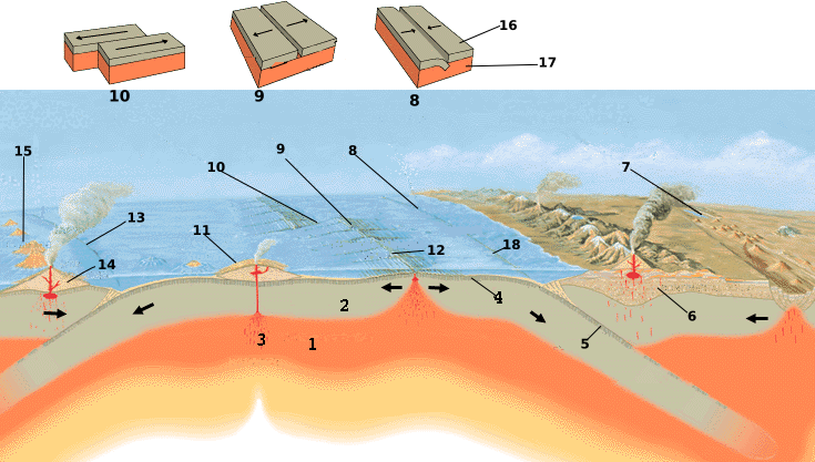
English: Tectonics plates map internationalized.
1-Asthenosphere; 2-Lithosphere; 3-Hot spot; 4-Oceanic crust; 5-Subducting plate; 6-Continental crust; 7-Continental rift zone (young plate boundary); 8-Convergent boundary plate; 9-Divergent boundary plate; 10-Transform plate boundary; 11-Shield volcano; 12-Oceanic spreading ridge; 13-Convergent plate boundary; 14-Strato volcano; 15-Island arc; 16-Plate 17-Asthenosphere; 18-TrenchFrançais : Carte de la tectonique des plaques.
1-Asthenosphère; 2-Lithosphère; 3-Point chaud; 4-Croûte océanique; 5-Plaque de subduction; 6-Croûte continentale; 7-Rift continental (divergence); 8-Fontière de plaques convergentes; 9-Fontière de plaques divergentes; 10-Faille transformante; 11-Volcan bouclier; 12-Dorsale océanique; 13-Fosse océanique; 14-Strato-volcan; 15-Arc insulaire; 16-Lithosphère; 17-Asthenosphere; 18-Fosse océanique Italiano: 1- Astenosfera; 2- Litosfera; 3- Punto caldo; 4- Crosta oceanica; 5- Placca in subduzione; 6- Crosta continentale; 7- Zona di rift continentale (Nuovo margine di placca); 8- Placca a margine convergente; 9- Placca a margine divergente; 10- Placca a margine trasforme; 11- Vulcano a scudo; 12- Dorsale oceanica; 13- Margine di placca convergente; 14- Strato vulcano; 15- Arco isola; 16- Placca; 17- Astenosfera; 18- Fossa
Español: Esquema de elementos asociados a las placas tectónicas.
1-Astenosfera; 2-Litosfera; 3-Punto caliente; 4-Corteza oceánica; 5-Plano de subducción; 6-Corteza continental y orogénesis; 7-Rift continental (inicio de la apertura de un nuevo océano); 8-Borde convergente; 9-Borde divergente; 10-Borde transformante; 11-Volcán en escudo; 12-Dorsal oceánica; 13-Borde convergente; 14-Estratovolcán; 15-Arco-isla; 16-Placa; 17-Astenosfera; 18-Fosa oceánica Català: Gràfic de la tectònica de plaques
1-Astenosfera; 2-Litosfera; 3-Punt calent; 4-Escorça oceànica; 5-Placa de subducció; 6-Escorça continental; 7-Rift continental; 8-Marges de les plaques convergents; 9-Marges de les plaques divergents; 10-Falla transformant; 11-Volcà d'escut; 12-Dorsal oceànica; 13-Fossa marina; 14-Estratovolcà; 15-Arc insular; 16-Litosfera; 17-Astenosfera; 18-Fossa Tiếng Việt: Bản đồ các mảng kiến tạo tổng quát.
1-Quyển mềm; 2-Thạch quyển; 3-Điểm nóng; 4-Vỏ đại dương; 5-Mảng hút chìm; 6-Vỏ lục địa; 7-Đới tách giản trên lục địa; 8-Ranh giới mảng hội tụ; 9-Ranh giới mảng phân kỳ; 10-Ranh giới mảng chuyển dạng; 11-Núi lửa dạng khiên; 12-Sống núi giữa đại dương; 13-Ranh giới mảng hội tụ; 14-Núi lửa Strato; 15-Cung đảo núi lửa; 16-Mảng 17-Quyển mềm; 18-Rãnh đại dươngPolski: Granice płyt tektonicznych.
1-Astenosfera; 2-Litosfera; 3-Plama gorąca; 4-Skorupa oceaniczna; 5-Subdukująca płyta; 6-Skorupa kontynentalna; 7-Dolina ryftowa (młoda granica płyt); 8-Zbieżna granica płyt; 9-Rozbieżna granica płyt; 10-Uskok transformacyjny; 11-Wulkan tarczowy; 12-Grzbiet śródoceaniczny; 13-Zbieżna granica płyt; 14-Stratowulkan; 15-Łuk wyspowy; 16-Płyta litosfery 17-Astenosfera; 18-Rów oceanicznyУкраїнська: Карта тектонічних плит. 1-Астеносфера; 2-Літосфера; 3-Гаряча точка; 4-Океанічна кора; 5-Субдуктивна плита; 6-Континентальна кора; 7-Континентальний розлом (межа молодої плити) ; 8-Збіжна межа плит; 9-Розбіжна межа плит; 10-Трансформний розлом; 11-Щитовий вулкан; 12-Океанічний хребет; 13-біжна межа плит; 14-Стратовулкан; 15-Острівна дуга; 16-Плита; 17-Астеносфера; 18-Океанічний жолоб |
| Source | http://commons.wikimedia.org/wiki/Image:Tectonic_plate_boundaries.png |
| Author | USGS/USGov, modified by Eurico Zimbres |
| Permission (Reusing this file) |
Free for all use |
Elementos associados às placas tectônicas: 1-Astenosfera; 2-Litosfera; 3-Ponto quente; 4-Crosta oceânica; 5-Plano de subducção; 6-Crosta continental e orogénese; 7-Rift Continental (início da abertura de um novo oceano); 8-borda convergente; 9-Borda divergente; 10-Transformar borda; 11- Escudo do vulcão; 12-Costa oceânica; 13-borda convergente; 14-Estratovulcão; 15-Arco-ilha; 16-Placa; 17-Astenosfera; 18-Fossa oceânica.
Licensing
[edit]
This work is in the public domain in the United States because it is a work prepared by an officer or employee of the United States Government as part of that person’s official duties under the terms of Title 17, Chapter 1, Section 105 of the US Code.
Note: This only applies to original works of the Federal Government and not to the work of any individual U.S. state, territory, commonwealth, county, municipality, or any other subdivision. This template also does not apply to postage stamp designs published by the United States Postal Service since 1978. (See § 313.6(C)(1) of Compendium of U.S. Copyright Office Practices). It also does not apply to certain US coins; see The US Mint Terms of Use.
|
 | |
| This file has been identified as being free of known restrictions under copyright law, including all related and neighboring rights. | ||
File history
Click on a date/time to view the file as it appeared at that time.
| Date/Time | Thumbnail | Dimensions | User | Comment | |
|---|---|---|---|---|---|
| current | 20:16, 3 October 2016 | | 735 × 417 (88 KB) | Cmdrjameson (talk | contribs) | Compressed with pngout. Reduced by 93kB (51% decrease). |
| 11:10, 22 May 2006 |  | 735 × 417 (181 KB) | Zimbres (talk | contribs) | ||
| 11:00, 22 May 2006 |  | 735 × 417 (166 KB) | Zimbres (talk | contribs) | {{Information| |Description= Tectonics plates map internationalized. 1-Astenosphere; 2-Litosphere; 3-Hot spot; 4-Oceanic crust; 5-Subducting plate; 6-Continental crust; 7-Continental rift zone (young plate boundary); 8-Convergent boundary plate; 9-Diverge |
You cannot overwrite this file.
File usage on Commons
The following 2 pages use this file:
File usage on other wikis
The following other wikis use this file:
- Usage on ar.wikipedia.org
- Usage on ca.wikipedia.org
- Usage on en.wikipedia.org
- Usage on es.wikipedia.org
- Usage on fr.wikipedia.org
- Usage on hr.wikipedia.org
- Usage on it.wikipedia.org
- Usage on it.wikibooks.org
- Usage on it.wikiversity.org
- Usage on sh.wikipedia.org
- Usage on sk.wikipedia.org
- Usage on sr.wikipedia.org
- Usage on tr.wikipedia.org
- Usage on uk.wikipedia.org
- Usage on vi.wikipedia.org