File:Take Ichi convoy.jpg
Jump to navigation
Jump to search

Size of this preview: 490 × 600 pixels. Other resolutions: 196 × 240 pixels | 392 × 480 pixels | 740 × 906 pixels.
Original file (740 × 906 pixels, file size: 93 KB, MIME type: image/jpeg)
Captions
Captions
Add a one-line explanation of what this file represents

|
This map image could be re-created using vector graphics as an SVG file. This has several advantages; see Commons:Media for cleanup for more information. If an SVG form of this image is available, please upload it and afterwards replace this template with
{{vector version available|new image name}}.
It is recommended to name the SVG file “Take Ichi convoy.svg”—then the template Vector version available (or Vva) does not need the new image name parameter. |


Summary
[edit]
| Description |
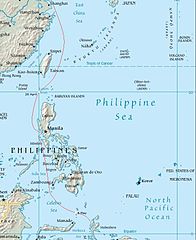
English: Map showing the route of the Japanese Take Ichi convoy and the location of the United States submarine attacks on the convoy. |
| Date | (UTC) |
| Source |
Own work using:
|
| Author |
Central Intelligence Agency |
| This is a retouched picture, which means that it has been digitally altered from its original version. Modifications: Convoy route added. The original can be viewed here: Southeast asia.jpg:
|
This image is in the public domain because it contains materials that originally came from the United States Central Intelligence Agency's World Factbook.
|
 |
Original upload log
[edit]
This image is a derivative work of the following images:
- File:Southeast_asia.jpg licensed with PD-USGov-CIA-WF
Uploaded with derivativeFX
File history
Click on a date/time to view the file as it appeared at that time.
| Date/Time | Thumbnail | Dimensions | User | Comment | |
|---|---|---|---|---|---|
| current | 07:53, 17 March 2009 | | 740 × 906 (93 KB) | Nick-D (talk | contribs) | {{Information |Description=May showing the route of the Japanese Take Ichi convoy and the location of the United States submarine attacks on the convoy. Convoy route is from Parillo, Mark P. (1993). ''The Japanese Merchant Marine in World War II''. Annapo |
You cannot overwrite this file.
File usage on Commons
There are no pages that use this file.
File usage on other wikis
The following other wikis use this file:
- Usage on br.wikipedia.org
- Usage on de.wikipedia.org
- Usage on en.wikipedia.org
- Usage on fr.wikipedia.org
- Usage on id.wikipedia.org
- Usage on ja.wikipedia.org
- Usage on pl.wikipedia.org
- Usage on ru.wikipedia.org
- Usage on www.wikidata.org
- Usage on wuu.wikipedia.org
- Usage on zh.wikipedia.org