File:Satellite image of Madagascar in September 2003.jpg
Jump to navigation
Jump to search
Size of this preview: 312 × 598 pixels. Other resolutions: 125 × 240 pixels | 250 × 480 pixels | 400 × 768 pixels | 534 × 1,024 pixels | 1,068 × 2,048 pixels | 3,214 × 6,164 pixels.
Original file (3,214 × 6,164 pixels, file size: 2.94 MB, MIME type: image/jpeg)
Captions
Captions
Add a one-line explanation of what this file represents
| Description |
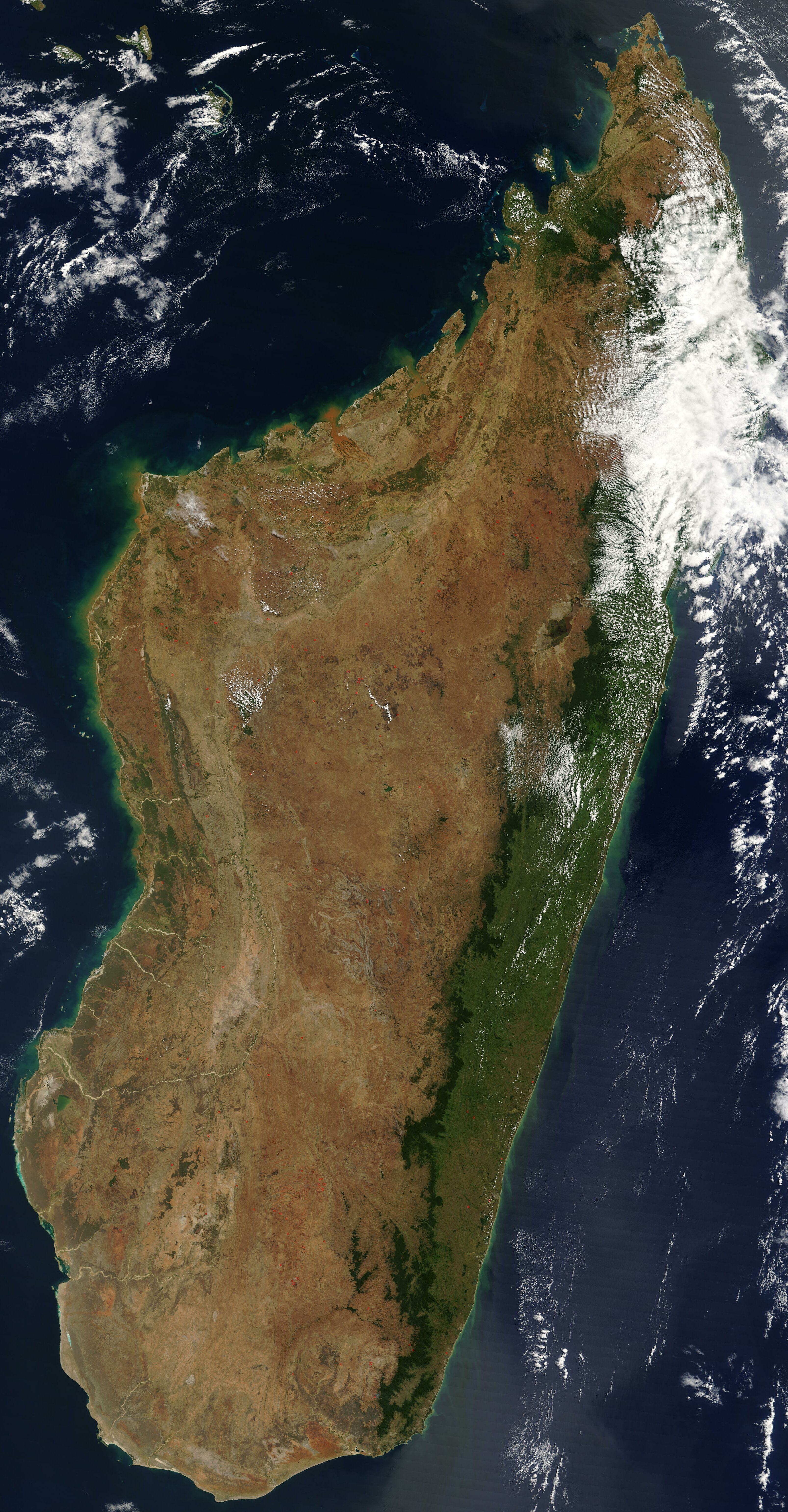
English: Satellite image of Madagascar in September 2003. Slightly cropped, original taken from NASA's Visible Earth: [1]. Original description:
|
| Date | |
| Source | http://visibleearth.nasa.gov/view_rec.php?id=5769 |
| Author | Unknown author |
This image was selected as picture of the day on Wikimedia Commons for 1 November 2005. It was captioned as follows: English: Satellite image of Madagascar in September Other languages:
Čeština: Pohled ze satelitu na Madagaskar (září 2003) Cymraeg: Delwedd lloeren o Madagascar (Medi 2003) Deutsch: Satellitenbild von Madagaskar English: Satellite image of Madagascar in September Español: Imagen satelital de Madagascar en septiembre Français : Image satellite de Madagascar (septembre 2003) Gaeilge: Radharc Madagascar ó spás. Italiano: Immagine satellitare dell'isola di Madagascar Latina: Madagascariae imago satellitia Nederlands: Sattellietfoto van Madagaskar in september. Norsk bokmål: Satellittbilde av Madagaskar. Norsk nynorsk: Satellittbilde av Madagaskar. Polski: Satelitarny obraz Madagaskaru (wrzesień 2003) Slovenčina: Satelitná snímka Madagaskaru (spetember 2003) Suomi: Syyskuinen Madagaskar satelliittikuvassa Svenska: Satellitbild av Madagaskar. Русский: Спутниковая фотография Мадагаскара, четвёртого по величине острова в мире, сделанная 10 сентября 2003 года. ไทย: ภาพถ่ายดาวเทียมเกาะมาดากัสการ์เมื่อเดือนกันยายน พ.ศ. ๒๕๔๖ 中文: 2003年9月马达加斯加的卫星照片 |
| This file is in the public domain in the United States because it was solely created by NASA. NASA copyright policy states that "NASA material is not protected by copyright unless noted". (See Template:PD-USGov, NASA copyright policy page or JPL Image Use Policy.) | ||
 |
Warnings:
|
File history
Click on a date/time to view the file as it appeared at that time.
| Date/Time | Thumbnail | Dimensions | User | Comment | |
|---|---|---|---|---|---|
| current | 12:51, 7 January 2005 | | 3,214 × 6,164 (2.94 MB) | Hautala (talk | contribs) | {{PD-USGov-NASA}} Satellite image of Madagascar in September 2003. Slightly cropped, original taken from NASA's Visible Earth http://visibleearth.nasa.gov/cgi-bin/viewrecord?25841 . Original description: The world’s fourth largest island, Madagasca |
You cannot overwrite this file.
File usage on Commons
The following 35 pages use this file:
- Atlas of Madagascar
- Madagasikara / Madagascar
- Maps of Madagascar
- Commons:Potd/2005-11 (fr)
- Commons:Potd/2005-11 (pl)
- Commons:Potd/2005-11 (pt)
- Commons:Potd/2005-11 (ru)
- Commons:Potd/2005-11 (sv)
- Commons:Potd/2005-11 (tr)
- File:Andasibe National Park, Madagascar (4027581120).jpg
- Template:Potd/2005-11
- Template:Potd/2005-11-01
- Template:Potd/2005-11-01 (cs)
- Template:Potd/2005-11-01 (cy)
- Template:Potd/2005-11-01 (de)
- Template:Potd/2005-11-01 (en)
- Template:Potd/2005-11-01 (es)
- Template:Potd/2005-11-01 (fi)
- Template:Potd/2005-11-01 (fr)
- Template:Potd/2005-11-01 (ga)
- Template:Potd/2005-11-01 (gl)
- Template:Potd/2005-11-01 (it)
- Template:Potd/2005-11-01 (ja)
- Template:Potd/2005-11-01 (la)
- Template:Potd/2005-11-01 (nb)
- Template:Potd/2005-11-01 (nl)
- Template:Potd/2005-11-01 (nn)
- Template:Potd/2005-11-01 (pl)
- Template:Potd/2005-11-01 (pt)
- Template:Potd/2005-11-01 (ru)
- Template:Potd/2005-11-01 (sk)
- Template:Potd/2005-11-01 (sv)
- Template:Potd/2005-11-01 (th)
- Template:Potd/2005-11-01 (zh-hans)
- Category:Madagascar
.jpg)
File usage on other wikis
The following other wikis use this file:
- Usage on af.wikipedia.org
- Usage on arz.wikipedia.org
- Usage on ast.wikipedia.org
- Usage on az.wikipedia.org
- Usage on ba.wikipedia.org
- Usage on be-tarask.wikipedia.org
- Usage on br.wikipedia.org
- Usage on ca.wikipedia.org
- Usage on ce.wikipedia.org
- Usage on ckb.wikipedia.org
- Usage on cs.wikipedia.org
- Usage on cv.wikipedia.org
- Usage on cy.wikipedia.org
- Usage on dag.wikipedia.org
- Usage on da.wikipedia.org
- Usage on de.wikivoyage.org
- Usage on diq.wikipedia.org
- Usage on en.wikipedia.org
- Usage on eo.wikipedia.org
- Usage on eo.wiktionary.org
- Usage on es.wikipedia.org
- Usage on et.wikipedia.org
- Usage on fa.wikipedia.org
- Usage on fi.wikipedia.org
- Usage on fi.wiktionary.org
- Usage on fr.wikipedia.org
- Usage on fr.wikivoyage.org
- Usage on ga.wikipedia.org
- Usage on gl.wikipedia.org
- Usage on gpe.wikipedia.org
- Usage on ha.wikipedia.org
- Usage on he.wikipedia.org
- Usage on ht.wikipedia.org
- Usage on hy.wikipedia.org
- Usage on ia.wikipedia.org
View more global usage of this file.