File:Physical map of Ancient Greece-ru.svg
Jump to navigation
Jump to search

Size of this PNG preview of this SVG file: 599 × 599 pixels. Other resolutions: 240 × 240 pixels | 480 × 480 pixels | 768 × 768 pixels | 1,023 × 1,024 pixels | 2,047 × 2,048 pixels | 11,987 × 11,994 pixels.
Original file (SVG file, nominally 11,987 × 11,994 pixels, file size: 12.98 MB)
Captions
Captions
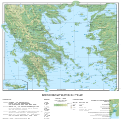
Physical map of Ancient Greece before the start of the Peloponnesian War
Summary
[edit]| Description |
Русский: Физическая карта Древней Греции с указанием географических объектов и городов
English: Physical map of Ancient Greece before the start of the Peloponnesian War, in Russian. |
| Date | |
| Source |
Источники для перевода названий:
|
| Author | Пётр Тарасьев |
| Other versions |
|
| SVG development | This vector image was created with Inkscape. This file uses embedded text that can be easily translated using a text editor. |

.jpg)
|

|
This SVG file contains embedded text that can be translated into your language, using any capable SVG editor, text editor or the SVG Translate tool. For more information see: About translating SVG files. |
Licensing
[edit]
I, the copyright holder of this work, hereby publish it under the following license:
This file is licensed under the Creative Commons Attribution-Share Alike 4.0 International license.
- You are free:
- to share – to copy, distribute and transmit the work
- to remix – to adapt the work
- Under the following conditions:
- attribution – You must give appropriate credit, provide a link to the license, and indicate if changes were made. You may do so in any reasonable manner, but not in any way that suggests the licensor endorses you or your use.
- share alike – If you remix, transform, or build upon the material, you must distribute your contributions under the same or compatible license as the original.
This image has been assessed using the Quality image guidelines and is considered a Quality image.
|

|
This image has been assessed under the valued image criteria and is considered the most valued image on Commons within the scope: Physical map of Ancient Greece in Russian language. You can see its nomination here. |
File history
Click on a date/time to view the file as it appeared at that time.
| Date/Time | Thumbnail | Dimensions | User | Comment | |
|---|---|---|---|---|---|
| current | 16:01, 4 November 2023 | | 11,987 × 11,994 (12.98 MB) | Пётр Тарасьев (talk | contribs) | Изменил обводку у городов "Миунт" |
| 14:49, 4 November 2023 |  | 11,987 × 11,994 (12.98 MB) | Пётр Тарасьев (talk | contribs) | Изменил обводку у городов "Писа" и "Арна (Гла)" | |
| 14:24, 4 November 2023 |  | 11,987 × 11,994 (12.98 MB) | Пётр Тарасьев (talk | contribs) | Добавил "Дворец Нестора", переместил города "Фивы Фтиотийские" и "Пирас" | |
| 15:09, 30 October 2023 |  | 11,987 × 11,994 (12.98 MB) | Пётр Тарасьев (talk | contribs) | Поменял название города на берегу региона "Этолия" - Элей на Олен (Элей); уточнил название колонки в легенде, внизу карты - "Размеры городов" на "Обозначение городов" | |
| 07:32, 7 October 2023 |  | 11,987 × 11,994 (12.98 MB) | Пётр Тарасьев (talk | contribs) | добавил пояснение в легенду | |
| 17:59, 8 October 2022 |  | 11,987 × 11,994 (12.98 MB) | Пётр Тарасьев (talk | contribs) | Убрал лишний пробел в легенде у Гексамилиона и исправил значок для разрушенных городов тоже в легенде | |
| 18:35, 4 October 2022 |  | 11,987 × 11,994 (12.98 MB) | Пётр Тарасьев (talk | contribs) | Изменил топоним Педион и добавил топоним Элевсинская равнина | |
| 18:01, 4 October 2022 |  | 11,987 × 11,994 (12.98 MB) | Пётр Тарасьев (talk | contribs) | Изменил "Педион" и добавил "Элевсинская равнина" | |
| 16:56, 13 September 2022 |  | 11,987 × 11,994 (12.98 MB) | Пётр Тарасьев (talk | contribs) | Отредактировал реку Кефис под землёй | |
| 16:50, 13 September 2022 |  | 11,987 × 11,994 (12.98 MB) | Пётр Тарасьев (talk | contribs) | Отредактировал реку Кефис под землёй |
You cannot overwrite this file.
File usage on Commons
The following 24 pages use this file:
- User:Magog the Ogre/Multilingual legend/2022 October 1-10
- User:Magog the Ogre/Multilingual legend/2022 September 11-20
- User:Magog the Ogre/Multilingual legend/2023 November 1-5
- User:Magog the Ogre/Multilingual legend/2023 October 27-31
- User:Magog the Ogre/Multilingual legend/2023 October 5-8
- User talk:Aristeas/Archive 2022
- User talk:Ilovemydoodle
- User talk:Пётр Тарасьев
- Commons:Featured picture candidates/File:Physical map of Ancient Greece-ru.svg
- Commons:Featured picture candidates/Log/October 2023
- Commons:Featured pictures/Non-photographic media/Maps
- Commons:Featured pictures/chronological/2023-B
- Commons:Featured pictures/chronological/October 2023
- Commons:Picture of the Year/2023/Candidates
- Commons:Picture of the Year/2023/R1/Gallery/2023-B
- Commons:Picture of the Year/2023/R1/Gallery/ALL
- Commons:Picture of the Year/2023/R1/Gallery/M10
- Commons:Picture of the Year/2023/R1/Gallery/Paintings, textiles and works on paper
- Commons:Picture of the Year/2023/R1/v/Physical map of Ancient Greece-ru.svg
- Commons:Quality images/Subject/Non photographic media
- Commons:Quality images candidates/Archives September 24 2022
- Commons:Valued image candidates/Physical map of Ancient Greece-ru.svg
- Commons:Valued images by topic/Places/Countries and regions
- File:Settlement map of the Greek tribes before the start of the Peloponnesian War-ru.svg
File usage on other wikis
The following other wikis use this file:
- Usage on be.wikipedia.org
- Usage on ru.wikipedia.org
- Древняя Греция
- Абдеры
- Микенская цивилизация
- Фессалия
- Эвмен из Кардии
- Древняя Македония
- Самос
- Микены
- Аттика
- Дарданеллы
- Хиос (город)
- Хиос
- Танагра
- Тегеатида
- Тегира
- Теос
- Крит
- Эпир
- Арголида
- Пелопоннес
- Коринф
- Спарта
- Тиринф
- Арриб
- Кносс
- Халкида
- Милет
- Галлипольский полуостров
- Додона
- Элефсис
- Калидон
- Пергам
- Пагаса
- Стагир
- Мегара
- Атарней
- Эвбея
- История Крита
- Аргос
- Тиррены
- Эгостена
- Элевферы
- Олимпия
- Фивы (Беотия)
- Беотия
- Фокида
- Локрида
- Этолия
- Элида
View more global usage of this file.