File:Kaiten bases locations.svg
Jump to navigation
Jump to search

Size of this PNG preview of this SVG file: 512 × 249 pixels. Other resolutions: 320 × 156 pixels | 640 × 311 pixels | 1,024 × 498 pixels | 1,280 × 623 pixels | 2,560 × 1,245 pixels.
Original file (SVG file, nominally 512 × 249 pixels, file size: 88 KB)
Captions
Captions
Add a one-line explanation of what this file represents
Summary
[edit]
| Description |
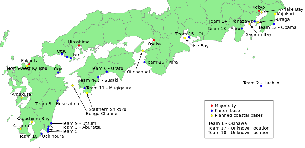
English: Locations of known Kaiten operating bases on the Japanese main islands. These bases were created to counter the impending invasion of the mainland by allied troops at the end of World War 2. |
| Date | |
| Source |
SVG outline from here: File:Blank_map_of_Japan.svg Information on locations taken partially from: jp:Kaiten http://www.asahi-net.or.jp/~un3k-mn/kaiten-attak3.htm |
| Author | Lakkasuo |
Licensing
[edit]
I, the copyright holder of this work, hereby publish it under the following licenses:
This file is licensed under the Creative Commons Attribution-Share Alike 3.0 Unported license.
- You are free:
- to share – to copy, distribute and transmit the work
- to remix – to adapt the work
- Under the following conditions:
- attribution – You must give appropriate credit, provide a link to the license, and indicate if changes were made. You may do so in any reasonable manner, but not in any way that suggests the licensor endorses you or your use.
- share alike – If you remix, transform, or build upon the material, you must distribute your contributions under the same or compatible license as the original.

|
Permission is granted to copy, distribute and/or modify this document under the terms of the GNU Free Documentation License, Version 1.2 or any later version published by the Free Software Foundation; with no Invariant Sections, no Front-Cover Texts, and no Back-Cover Texts. A copy of the license is included in the section entitled GNU Free Documentation License. |
You may select the license of your choice.
File history
Click on a date/time to view the file as it appeared at that time.
| Date/Time | Thumbnail | Dimensions | User | Comment | |
|---|---|---|---|---|---|
| current | 19:13, 15 September 2010 | | 512 × 249 (88 KB) | Lakkasuo (talk | contribs) | Added planned bases and a few little alterations. |
| 20:24, 14 September 2010 |  | 512 × 255 (66 KB) | Lakkasuo (talk | contribs) | {{Information |Description={{en|1=Locations of known Kaiten operating bases on the Japanese main islands. These bases were created to counter the impending invasion of the mainland by allied troops at the end of World War 2.}} |Source=SVG outline from her |
You cannot overwrite this file.
File usage on Commons
There are no pages that use this file.
File usage on other wikis
The following other wikis use this file:
- Usage on de.wikipedia.org
- Usage on en.wikipedia.org
- Usage on fr.wikipedia.org
- Usage on it.wikipedia.org