File:Japanese expansion april 1942 - español.svg
Jump to navigation
Jump to search

Size of this PNG preview of this SVG file: 800 × 467 pixels. Other resolutions: 320 × 187 pixels | 640 × 374 pixels | 1,024 × 598 pixels | 1,280 × 747 pixels | 2,560 × 1,494 pixels | 1,064 × 621 pixels.
Original file (SVG file, nominally 1,064 × 621 pixels, file size: 441 KB)
Captions
Captions
Add a one-line explanation of what this file represents
Summary
[edit]| Description |
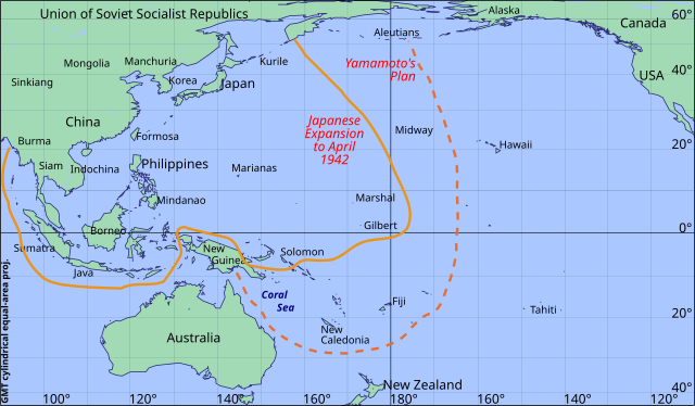
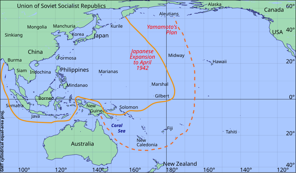
Español: Expansión japonesa en el Pacífico hasta abril de 1942, de acuerdo a "Der Zweite Weltkrieg", por es:Winston Curchil) (versión en alemán), página 619
English: Japanese expansion april 1942 according to "Der Zweite Weltkrieg", by en:Winston Churchill (German Version) page 619. |
||||||||||
| Date | |||||||||||
| Source | File:Japanese_expansion_april_1942.svg | ||||||||||
| Author | Createaccount | ||||||||||
| Permission (Reusing this file) |
|

Licensing
[edit]
This file is licensed under the Creative Commons Attribution-Share Alike 3.0 Unported license.
- You are free:
- to share – to copy, distribute and transmit the work
- to remix – to adapt the work
- Under the following conditions:
- attribution – You must give appropriate credit, provide a link to the license, and indicate if changes were made. You may do so in any reasonable manner, but not in any way that suggests the licensor endorses you or your use.
- share alike – If you remix, transform, or build upon the material, you must distribute your contributions under the same or compatible license as the original.
File history
Click on a date/time to view the file as it appeared at that time.
| Date/Time | Thumbnail | Dimensions | User | Comment | |
|---|---|---|---|---|---|
| current | 23:30, 9 October 2019 | | 1,064 × 621 (441 KB) | Amílcar (talk | contribs) | User created page with UploadWizard |
You cannot overwrite this file.
File usage on Commons
The following 6 pages use this file:
- User:Chumwa/OgreBot/Potential transport maps/2019 October 1-10
- User:Chumwa/OgreBot/Transport Maps/2019 October 1-10
- User:Chumwa/OgreBot/Travel and communication maps/2019 October 1-10
- User:Holly Cheng/Recent uploads/Hawaii/2019 October 9
- User:Magog the Ogre/Maps of conflicts/2019 October
- Commons:WikiProject Aviation/recent uploads/2019 October 9