File:Hokushin-ron-Map.png
Jump to navigation
Jump to search

Size of this preview: 800 × 486 pixels. Other resolutions: 320 × 194 pixels | 640 × 389 pixels | 1,013 × 615 pixels.
Original file (1,013 × 615 pixels, file size: 187 KB, MIME type: image/png)
Captions
Captions
Add a one-line explanation of what this file represents

|
File:Hokushin-ron-Map.svg is a vector version of this file. It should be used in place of this PNG file when not inferior.
File:Hokushin-ron-Map.png → File:Hokushin-ron-Map.svg
For more information, see Help:SVG. |
 |
| Description |
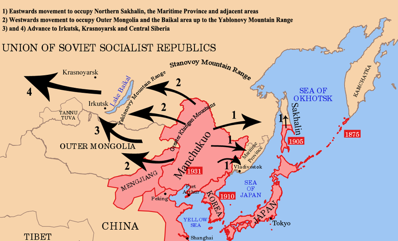
English: Strategic map of "Hoshukin-ron", the Japanese plans for a potential attack on the Soviet Union. |
| Date |
|
| Source | |
| Author | |
| Other versions | Derivative works of this file: Hokushin-ron-Map.svg |
I, the copyright holder of this work, hereby publish it under the following licenses:
This file is licensed under the Creative Commons Attribution-Share Alike 3.0 Unported license.
- You are free:
- to share – to copy, distribute and transmit the work
- to remix – to adapt the work
- Under the following conditions:
- attribution – You must give appropriate credit, provide a link to the license, and indicate if changes were made. You may do so in any reasonable manner, but not in any way that suggests the licensor endorses you or your use.
- share alike – If you remix, transform, or build upon the material, you must distribute your contributions under the same or compatible license as the original.

|
Permission is granted to copy, distribute and/or modify this document under the terms of the GNU Free Documentation License, Version 1.2 or any later version published by the Free Software Foundation; with no Invariant Sections, no Front-Cover Texts, and no Back-Cover Texts. A copy of the license is included in the section entitled GNU Free Documentation License. |
You may select the license of your choice.

Original upload log
[edit]
This image is a derivative work of the following images:
- File:Pacific_Area_-_The_Imperial_Powers_1939_-_Map.svg licensed with Cc-by-sa-3.0, GFDL
- 2009-05-31T02:33:19Z Kmusser 1039x814 (4658296 Bytes) add macau, fix marianas, hainan spelling
- 2008-10-30T15:20:49Z Valentim 1039x814 (4703043 Bytes) Reverted to version as of 05:16, 22 September 2008. The international name is "Sea of Japan".
- 2008-09-24T07:42:22Z 쿠도군 1039x814 (4704268 Bytes) Reverted to version as of 07:53, 11 September 2008
- 2008-09-22T05:16:58Z Chris 73 1039x814 (4703043 Bytes) Reverted to version as of 02:54, 21 August 2008
- 2008-09-11T07:53:32Z 쿠도군 1039x814 (4704268 Bytes) new version.
- 2008-08-21T02:54:43Z Emok 1039x814 (4703043 Bytes) {{Information |Description= |Source= |Date= |Author= |Permission= |other_versions= }}
- 2008-08-21T02:44:29Z Emok 1039x814 (4702923 Bytes) {{Information |Description= |Source= |Date= |Author= |Permission= |other_versions= }}
- 2008-08-08T01:16:33Z Emok 1039x814 (4678233 Bytes) {{Information |Description= |Source= |Date= |Author= |Permission= |other_versions= }}
- 2008-08-08T00:07:48Z Emok 1039x814 (4669659 Bytes) {{Information |Description= |Source= |Date= |Author= |Permission= |other_versions= }}
- 2008-08-07T05:03:23Z Emok 1039x814 (4669195 Bytes) {{Information |Description= |Source= |Date= |Author= |Permission= |other_versions= }}
- 2008-08-07T04:28:58Z Emok 1039x814 (4623405 Bytes) {{Information |Description= |Source= |Date= |Author= |Permission= |other_versions= }}
- 2008-08-07T04:02:57Z Emok 1039x814 (4602891 Bytes) {{Information |Description= |Source= |Date= |Author= |Permission= |other_versions= }}
- 2008-08-07T03:24:03Z Emok 1039x814 (4669511 Bytes) {{Information |Description= |Source= |Date= |Author= |Permission= |other_versions= }}
- 2008-08-04T16:59:39Z Emok 1039x814 (6442489 Bytes) {{Information |Description= |Source= |Date= |Author= |Permission= |other_versions= }}
- 2008-08-04T05:38:24Z Emok 1039x814 (6427678 Bytes) {{Information |Description= |Source= |Date= |Author= |Permission= |other_versions= }} [[Category:Imperialism]] [[Category:Oceania]]
- 2008-08-04T05:26:00Z Emok 104x82 (4765313 Bytes) {{Information |Description={{en|1=A map of the Imperial Powers of the Pacific, 1939-09-01. }} |Source=*[[:Image:World2Hires_filled_mercator.svg|]] |Date=2008-08-04 05:22 (UTC) |Author=*derivative work: ~~~ *[[:Image:World2Hir
Uploaded with derivativeFX
File history
Click on a date/time to view the file as it appeared at that time.
| Date/Time | Thumbnail | Dimensions | User | Comment | |
|---|---|---|---|---|---|
| current | 03:34, 16 January 2012 | | 1,013 × 615 (187 KB) | Quigley (talk | contribs) | Xinjiang definitely wasn't legally separated from China (Mongolia is a questionable case, Tibet even more so) |
| 14:40, 26 August 2010 |  | 1,013 × 615 (181 KB) | Begoon (talk | contribs) | remove headline/tweak type | |
| 18:41, 13 January 2010 |  | 1,013 × 615 (243 KB) | 36ophiuchi~commonswiki (talk | contribs) | Fixed some minor errors. | |
| 23:12, 11 January 2010 |  | 1,013 × 615 (241 KB) | 36ophiuchi~commonswiki (talk | contribs) | {{Information |Description={{en|1=Strategic map of "Hoshukin-ron", the Japanese plans for a potential attack on the Soviet Union.}} |Source=*File:Pacific_Area_-_The_Imperial_Powers_1939_-_Map.svg |Date=2010-01-11 23:11 (UTC) |Author=*[[:File:Pacific |
You cannot overwrite this file.
File usage on Commons
There are no pages that use this file.
File usage on other wikis
The following other wikis use this file:
- Usage on en.wikipedia.org