File:History of Korea-476.PNG
Jump to navigation
Jump to search

Size of this preview: 507 × 599 pixels. Other resolutions: 203 × 240 pixels | 406 × 480 pixels | 970 × 1,146 pixels.
Original file (970 × 1,146 pixels, file size: 866 KB, MIME type: image/png)
Captions
Captions
Add a one-line explanation of what this file represents
Summary
[edit]
| Description |
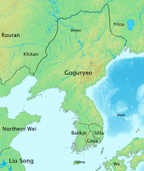
English: The map of history of Korea in 476, the moment of greatest territorial expansion of Goguryeo.
한국어: 한국사 지도 - 476년, 고구려 전성기때의 지도. |
| Date | |
| Source | Own work |
| Author | Myself |
Licensing
[edit]
I, the copyright holder of this work, hereby publish it under the following license:
This file is licensed under the Creative Commons Attribution-Share Alike 3.0 Unported license.
- You are free:
- to share – to copy, distribute and transmit the work
- to remix – to adapt the work
- Under the following conditions:
- attribution – You must give appropriate credit, provide a link to the license, and indicate if changes were made. You may do so in any reasonable manner, but not in any way that suggests the licensor endorses you or your use.
- share alike – If you remix, transform, or build upon the material, you must distribute your contributions under the same or compatible license as the original.
File history
Click on a date/time to view the file as it appeared at that time.
| Date/Time | Thumbnail | Dimensions | User | Comment | |
|---|---|---|---|---|---|
| current | 08:51, 4 October 2008 | | 970 × 1,146 (866 KB) | Historiographer~commonswiki (talk | contribs) | {{Information |Description= |Source= |Date= |Author= |Permission= |other_versions= }} |
| 05:37, 3 July 2008 |  | 970 × 1,146 (571 KB) | Historiographer~commonswiki (talk | contribs) | {{Information |Description= |Source= |Date= |Author= |Permission= |other_versions= }} | |
| 14:48, 14 June 2008 |  | 970 × 1,146 (873 KB) | Historiographer~commonswiki (talk | contribs) | {{Information |Description= |Source= |Date= |Author= |Permission= |other_versions= }} | |
| 14:46, 14 June 2008 |  | 970 × 1,146 (568 KB) | Historiographer~commonswiki (talk | contribs) | {{Information |Description= |Source= |Date= |Author= |Permission= |other_versions= }} | |
| 13:47, 12 June 2008 |  | 970 × 1,146 (874 KB) | Historiographer~commonswiki (talk | contribs) | {{Information |Description={{en|1=The map of history of Korea in 476, The greatest territory expansion of Goguryeo. }} {{ko|1=한국사 지도 - 476년, 고구려 전성기때의 지도.}} |Source=Self-made |Author=Myself |Date=2008-06-10 |Permission= |ot |
You cannot overwrite this file.
File usage on Commons
The following 5 pages use this file:
File usage on other wikis
The following other wikis use this file:
- Usage on ang.wikipedia.org
- Usage on ast.wikipedia.org
- Usage on azb.wikipedia.org
- Usage on az.wikipedia.org
- Usage on ba.wikipedia.org
- Usage on be-tarask.wikipedia.org
- Usage on be.wikipedia.org
- Usage on br.wikipedia.org
- Usage on ca.wikipedia.org
- Usage on cdo.wikipedia.org
- Usage on ckb.wikipedia.org
- Usage on cs.wikipedia.org
- Usage on cy.wikipedia.org
- Usage on da.wikipedia.org
- Usage on da.wikibooks.org
- Usage on de.wikipedia.org
- Usage on en.wikipedia.org
View more global usage of this file.