File:Hausa language niger.png
Jump to navigation
Jump to search

Size of this preview: 760 × 599 pixels. Other resolutions: 304 × 240 pixels | 609 × 480 pixels | 974 × 768 pixels | 1,280 × 1,010 pixels | 2,410 × 1,901 pixels.
Original file (2,410 × 1,901 pixels, file size: 116 KB, MIME type: image/png)
Captions
Captions
Add a one-line explanation of what this file represents

|
This linguistic map image could be re-created using vector graphics as an SVG file. This has several advantages; see Commons:Media for cleanup for more information. If an SVG form of this image is available, please upload it and afterwards replace this template with
{{vector version available|new image name}}.
It is recommended to name the SVG file “Hausa language niger.svg”—then the template Vector version available (or Vva) does not need the new image name parameter. |
Summary
[edit]
| Description |
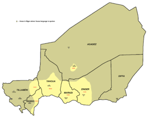
English: Areas in Niger where Hausa language is spoken. Note: Speakers of Hausa are mixed with speakers of other languages and thus this map does not necessarily represent areas with Hausa speaking majority. |
| Date | |
| Source | Own work |
| Author | PANONIAN |
Licensing
[edit]
I, the copyright holder of this work, hereby publish it under the following license:
| This file is made available under the Creative Commons CC0 1.0 Universal Public Domain Dedication. | |
| The person who associated a work with this deed has dedicated the work to the public domain by waiving all of their rights to the work worldwide under copyright law, including all related and neighboring rights, to the extent allowed by law. You can copy, modify, distribute and perform the work, even for commercial purposes, all without asking permission.
|
References
[edit]
- Linguistic map of Niger from www.ethnologue.com: http://www.ethnologue.com/maps/ner_eth.jpg
- Borders of provinces of Niger (and locations of provincial capitals) are drawn according to the UN map of Niger: http://commons.wikimedia.org/wiki/File:Un-niger.png
- Sizable cities in Niger are selected in accordance with the info from World Gazetteer page for Niger: http://world-gazetteer.com/wg.php?x=&men=gcis&lng=en&des=wg&srt=npan&col=abcdefghinoq&msz=1500&geo=-156[dead link]
- Aditional source about presence of Hausa speakers in Agadez: http://www.saudiaramcoworld.com/issue/200301/agadez-sultanate.of.the.sahara.htm archive copy at the Wayback Machine
File history
Click on a date/time to view the file as it appeared at that time.
| Date/Time | Thumbnail | Dimensions | User | Comment | |
|---|---|---|---|---|---|
| current | 12:38, 24 June 2011 | | 2,410 × 1,901 (116 KB) | PANONIAN (talk | contribs) | {{Information |Description ={{en|1=Areas in Niger where Hausa language is spoken.}} |Source ={{own}} |Author =PANONIAN |Date = |Permission = |other_versions = }} |
You cannot overwrite this file.
File usage on Commons
The following 2 pages use this file:
File usage on other wikis
The following other wikis use this file:
- Usage on ar.wikipedia.org
- Usage on frr.wikipedia.org