File:Deutschland (Städte).png
Jump to navigation
Jump to search
Size of this preview: 448 × 599 pixels. Other resolutions: 179 × 240 pixels | 603 × 806 pixels.
Original file (603 × 806 pixels, file size: 81 KB, MIME type: image/png)
Captions
Captions
Add a one-line explanation of what this file represents

|
This map has been uploaded by Electionworld from de.wikipedia.org to enable the |

|
This map image could be re-created using vector graphics as an SVG file. This has several advantages; see Commons:Media for cleanup for more information. If an SVG form of this image is available, please upload it and afterwards replace this template with
{{vector version available|new image name}}.
It is recommended to name the SVG file “Deutschland (Städte).svg”—then the template Vector version available (or Vva) does not need the new image name parameter. |
| Description |
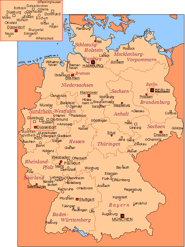
Deutschlandkarte mit den wichtigsten Städten. Eingetragen sind:
|
| Date | |
| Source | Own work |
| Author | de:Benutzer:Korny78 |

|
Permission is granted to copy, distribute and/or modify this document under the terms of the GNU Free Documentation License, Version 1.2 or any later version published by the Free Software Foundation; with no Invariant Sections, no Front-Cover Texts, and no Back-Cover Texts. A copy of the license is included in the section entitled GNU Free Documentation License. |
| This file is licensed under the Creative Commons Attribution-Share Alike 3.0 Unported license. | ||
| ||
| This licensing tag was added to this file as part of the GFDL licensing update. |
Bundesländer & Hauptstädte'
- Bremen - Bremen
- Mecklenburg-Vorpommern - Schwerin
- Niedersachsen - Hannover
- Brandenburg - Potsdam
- Nordrhein-Westfalen - Düsseldorf
- Berlin - Berlin
- Sachsen-Anhalt - Magdeburg
- Thüringen - Erfurt
- Hessen - Wiesbaden
- Sachsen - Dresden
- Rheinland-Pfalz - Mainz
- Saarland - Saarbrücken
- Bayern - München
- Baden-Württemberg - Stuttgart
File history
Click on a date/time to view the file as it appeared at that time.
| Date/Time | Thumbnail | Dimensions | User | Comment | |
|---|---|---|---|---|---|
| current | 19:33, 16 March 2020 | | 603 × 806 (81 KB) | HerrMay (talk | contribs) | Dresden, Leipzig, Nürnberg aktualisiert |
| 22:18, 1 January 2007 |  | 603 × 806 (121 KB) | Electionworld (talk | contribs) | {{ew|de|Korny78}} {{In SVG konvertieren}} {{Information |Description=Deutschlandkarte mit den wichtigsten Städten. Eingetragen sind: * alle Städte, die mindestens 100.000 Einwohner haben (Großstädte; Stand: 2003), * alle Städte, die in der Vergangen |
You cannot overwrite this file.
File usage on Commons
The following page uses this file:
File usage on other wikis
The following other wikis use this file:
- Usage on be-tarask.wikipedia.org
- Usage on de.wikipedia.org
- Usage on en.wikipedia.org
- Usage on nl.wikipedia.org
- Usage on rm.wikipedia.org
.png&oldid=606408932)