File:Cilician Armenia-en.svg
Jump to navigation
Jump to search

Size of this PNG preview of this SVG file: 800 × 571 pixels. Other resolutions: 320 × 228 pixels | 640 × 457 pixels | 1,024 × 730 pixels | 1,280 × 913 pixels | 2,560 × 1,826 pixels | 2,508 × 1,789 pixels.
Original file (SVG file, nominally 2,508 × 1,789 pixels, file size: 713 KB)
Captions
Captions
Add a one-line explanation of what this file represents
Summary
[edit]| Description |
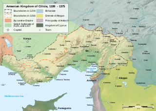
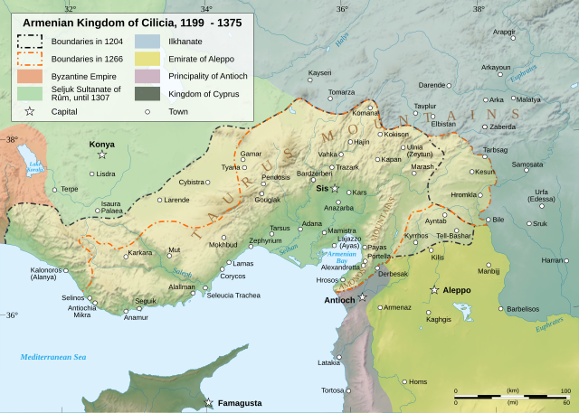
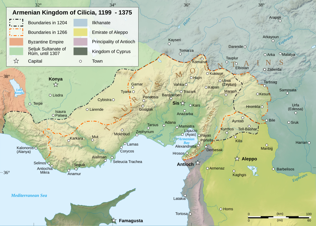
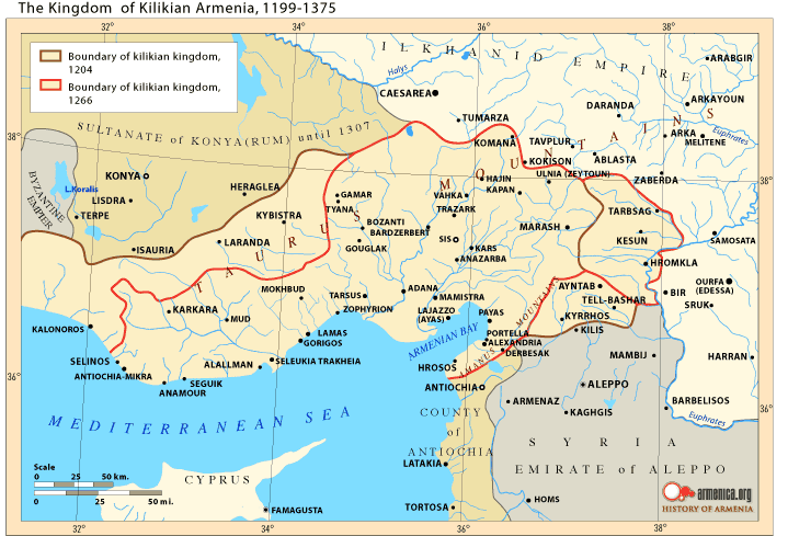
Čeština: Mapa Arménského království v Kilíkii v 13. století. Deutsch: Karte des Armenischen Königreichs von Kilikien während des 13. Jahrhunderts. English: Map of the Armenian Kingdom of Cilicia during the XIII century. Español: Mapa del siglo XIII del Reino armenio de Cilicia. Esperanto: Mapo de la Armena reĝlando en Kilikio dum la 13-a jarcento. Français : Carte en anglais du royaume de Petite Arménie (en Cilicie) au XIIIe siècle. Italiano: Mappa topografica del regno armeno di Cilicia durante il XIII secolo. Kapampangan: Metung a mapa ning Kaariang Armenian ning Cilicia aniang ka-XIII a dilanua o siglu. Magyar: A Kilikiai Örmény Királyság 13. századi állapotát mutató térkép. Nederlands: Engelstalige kaart van Cilicisch Armenië in de 13e eeuw. Polski: Mapa Armenii Małej w XIII wieku. Português: Mapa do Reino Armênio da Cilícia no século XIII. Svenska: En karta över det armeniska kungariket Kilikien under 1200-talet. Türkçe: 13. yüzyılda Kilikya Ermeni Krallığı'nın sınırları. Беларуская: Карта Кілійскага армянскага царства (13 ст.) Македонски: Карта на Ерменското кралство Киликија во XIII век. Հայերեն : Կիլիկիայի Հայկական Թագավորության քարտեզը 13րդ դարում. বাংলা : ত্রয়োদশ শতকের সিলিসিয়ার আর্মেনীয় রাজত্বের মানচিত্র। 한국어: 13세기 킬리키아 아르메니아 왕국의 지도 日本語: 13世紀のキリキア・アルメニア王国の地図。 中文(简体): 奇里乞亚亚美尼亚王国13世纪地图 中文(繁體): 奇里乞亞亞美尼亞王國13世紀地圖 العربية : خريطة لمملكة قيليقية الأرمينية خلال القرن الثالث عشر مازِرونی : نخشه پادشائی کلیسائ ارمنی قرن |
||||||||
| Date | |||||||||
| Source |
Own work. English: Sources :
Software used :
Other data :
Français : Sources :
Logiciels utilisés :
Autres données :
|
||||||||
| Creator | |||||||||
| Georeferencing | If inappropriate please set warp_status = skip to hide. | ||||||||
| Other versions |
[]
| ||||||||
| Attribution (required by the license) | © Sémhur / Wikimedia Commons / | ||||||||
| Assessments |
|
||||||||
| SVG |
|
||||||||
| Graphic Lab |


| Camera location | | View this and other nearby images on: OpenStreetMap |
|---|
Licensing
[edit]
I, the copyright holder of this work, hereby publish it under the following licenses:
| Copyleft: This work of art is free; you can redistribute it and/or modify it according to terms of the Free Art License. You will find a specimen of this license on the Copyleft Attitude site as well as on other sites. |
This file is licensed under the Creative Commons Attribution-Share Alike Attribution-Share Alike 4.0 International, 3.0 Unported, 2.5 Generic, 2.0 Generic and 1.0 Generic license.
- You are free:
- to share – to copy, distribute and transmit the work
- to remix – to adapt the work
- Under the following conditions:
- attribution – You must give appropriate credit, provide a link to the license, and indicate if changes were made. You may do so in any reasonable manner, but not in any way that suggests the licensor endorses you or your use.
- share alike – If you remix, transform, or build upon the material, you must distribute your contributions under the same or compatible license as the original.
You may select the license of your choice.
I, the copyright holder of this work, hereby publish it under the following license:

|
Permission is granted to copy, distribute and/or modify this document under the terms of the GNU Free Documentation License, Version 1.2 or any later version published by the Free Software Foundation; with no Invariant Sections, no Front-Cover Texts, and no Back-Cover Texts. A copy of the license is included in the section entitled GNU Free Documentation License. |
| This file is licensed under the Creative Commons Attribution-Share Alike 3.0 Unported license. | ||
| ||
| This licensing tag was added to this file as part of the GFDL licensing update. |
File history
Click on a date/time to view the file as it appeared at that time.
| Date/Time | Thumbnail | Dimensions | User | Comment | |
|---|---|---|---|---|---|
| current | 19:23, 9 March 2023 | | 2,508 × 1,789 (713 KB) | Ömer faruk çakmak (talk | contribs) | File uploaded using svgtranslate tool (https://svgtranslate.toolforge.org/). Added translation for tr. |
| 18:29, 9 March 2023 |  | 2,508 × 1,789 (691 KB) | Ömer faruk çakmak (talk | contribs) | File uploaded using svgtranslate tool (https://svgtranslate.toolforge.org/). Added translation for tr. | |
| 10:58, 17 January 2008 |  | 2,508 × 1,789 (671 KB) | Sémhur (talk | contribs) | Correcting few bugs (x2) | |
| 10:55, 17 January 2008 |  | 2,508 × 1,789 (671 KB) | Sémhur (talk | contribs) | Correcting few bugs | |
| 19:42, 16 January 2008 |  | 2,508 × 1,789 (671 KB) | Sémhur (talk | contribs) | heavier... Too bad | |
| 19:33, 16 January 2008 |  | 2,508 × 1,789 (261 KB) | Sémhur (talk | contribs) | bigger size, lighter weight, + coordinates | |
| 11:38, 13 January 2008 |  | 1,458 × 991 (362 KB) | Sémhur (talk | contribs) | == Description == {{Information |Description= {{en| Map of the Armenian Kingdom of Cilicia during the XIII century.}} {{fr| Carte en anglais du royaume de Petite Arménie (en Cilicie) au XIII<sup>ème</sup> siècle.}} |S |
You cannot overwrite this file.
File usage on Commons
The following 62 pages use this file:
- Atlas of Armenia
- Atlas of Turkey
- Atlas of the Levant
- User:Magog the Ogre/Multilingual legend/2023 March 1-10
- User:Miya/POTY/Diagrams2008
- User:Notafish/Votes 2008
- User:Sémhur
- User talk:Sting/Archive 01
- Commons:Featured picture candidates/Image:Cilician Armenia-en.svg
- Commons:Featured picture candidates/Log/January 2008
- Commons:Featured pictures/Non-photographic media/Maps
- Commons:Featured pictures/chronological/2008-A
- Commons:Picture of the Year/2008/Galleries/All
- Commons:Picture of the Year/2008/Galleries/Diagrams
- Commons:Picture of the Year/2008/Results/Round 1/Gallery/All
- Commons:Picture of the Year/2008/Results/Round 1/Gallery/Diagrams
- Commons:Picture of the Year 2008/File:Cilician Armenia-en.svg
- Commons:Potd/2010-03 (da)
- Commons:Potd/2010-03 (de)
- Commons:Potd/2010-03 (nl)
- Commons:Potd/2010-03 (pt)
- File:Armenianmeds.gif
- File:Cilician Armenia-ar.svg
- File:Cilician Armenia-cs.svg
- File:Cilician Armenia-en.svg
- File:Cilician Armenia-fr.svg
- File:Cilician Armenia-hu.svg
- File:Cilician Armenia-it.svg
- File:Cilician Armenia-sv.svg
- Template:Other versions/Cilician Armenia
- Template:Potd/2010-03
- Template:Potd/2010-03-04
- Template:Potd/2010-03-04 (ar)
- Template:Potd/2010-03-04 (be)
- Template:Potd/2010-03-04 (bn)
- Template:Potd/2010-03-04 (ca)
- Template:Potd/2010-03-04 (cs)
- Template:Potd/2010-03-04 (da)
- Template:Potd/2010-03-04 (de)
- Template:Potd/2010-03-04 (en)
- Template:Potd/2010-03-04 (eo)
- Template:Potd/2010-03-04 (es)
- Template:Potd/2010-03-04 (fr)
- Template:Potd/2010-03-04 (hu)
- Template:Potd/2010-03-04 (hy)
- Template:Potd/2010-03-04 (it)
- Template:Potd/2010-03-04 (ja)
- Template:Potd/2010-03-04 (ko)
- Template:Potd/2010-03-04 (mk)
- Template:Potd/2010-03-04 (mzn)
- Template:Potd/2010-03-04 (nl)
- Template:Potd/2010-03-04 (pam)
- Template:Potd/2010-03-04 (pl)
- Template:Potd/2010-03-04 (pt)
- Template:Potd/2010-03-04 (ru)
- Template:Potd/2010-03-04 (sv)
- Template:Potd/2010-03-04 (uk)
- Template:Potd/2010-03-04 (zh-hans)
- Template:Potd/2010-03-04 (zh-hant)
- Template:Potd/2010-03 (zh-hans)
- Category:Armenian Kingdom of Cilicia
- Category:Armenian Kings of Cilicia
File usage on other wikis
The following other wikis use this file:
- Usage on als.wikipedia.org
- Usage on an.wikipedia.org
- Usage on arz.wikipedia.org
- Usage on ast.wikipedia.org
- Usage on azb.wikipedia.org
- Usage on az.wikipedia.org
- Usage on ba.wikipedia.org
- Usage on be.wikipedia.org
- Usage on bg.wikipedia.org
- Usage on bn.wikipedia.org
- Usage on ca.wikipedia.org
- Usage on crh.wikipedia.org
- Usage on cs.wikipedia.org
- Usage on cv.wikipedia.org
- Usage on de.wikipedia.org
- Usage on el.wikipedia.org
- Usage on en.wikipedia.org
- Cilicia
- History of Armenia
- List of monarchs of the Armenian Kingdom of Cilicia
- Hethum II
- Leo I, King of Armenia
- Rumkale
- Armenian Kingdom of Cilicia
- Toros Roslin
- Armenian illuminated manuscripts
- Portal:Maps/Maps/Political
- Portal:Maps/Maps/Political/12
- Second Battle of Sarvandik'ar
- Wikipedia:Wikipedia Signpost/2012-04-30/WikiProject report
- Wikipedia:Wikipedia Signpost/Single/2012-04-30
- Wikipedia:Featured picture candidates/May-2013
- Wikipedia:Featured picture candidates/Cilician Armenia
- History of Cilicia
- Talk:Armenia/Archive 9
- Zayn al-Din Qaraja
- Ghars al-Din Khalil
- Ibrahim I of Ramadan
- User:Falcaorib/Medieval Empires (1300-1500 AD)
View more global usage of this file.
Metadata
Categories:
- Maps of Cilicia
- Maps of the Armenian Kingdom of Cilicia
- SVG maps of the history of Armenia
- Maps of the history of Turkey
- Maps of the history of Syria
- Maps showing 12th-century history
- Maps showing 13th-century history
- Maps showing 14th-century history
- Topographic maps of the Middle East
- English-language SVG maps showing history