File:Ceara RM Fortaleza.svg
Jump to navigation
Jump to search

Size of this PNG preview of this SVG file: 509 × 599 pixels. Other resolutions: 204 × 240 pixels | 408 × 480 pixels | 652 × 768 pixels | 870 × 1,024 pixels | 1,740 × 2,048 pixels | 581 × 684 pixels.
Original file (SVG file, nominally 581 × 684 pixels, file size: 225 KB)
Captions
Captions
Add a one-line explanation of what this file represents
Summary
[edit]
| Description |
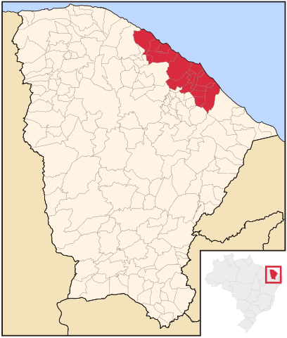
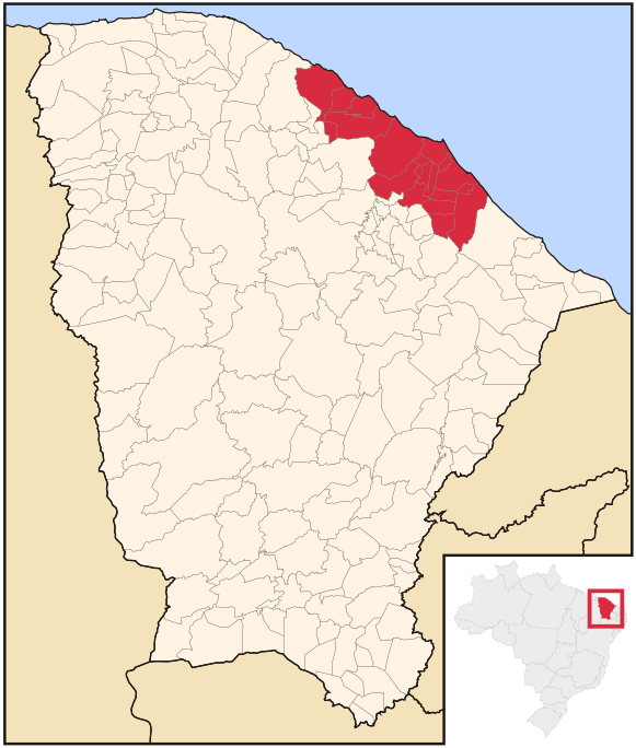
English: Map locator of the Metropolitan Region of Fortaleza, CE.
Português: Mapa de localização da Região Metropolitana de Fortaleza, CE.
This W3C-unspecified vector image was created with Inkscape . |
| Date | (UTC) |
| Source |
This file was derived from: Ceara Meso MetropolitanadeFortaleza.svg:  |
| Author |
|
Licensing
[edit]
Luan, the copyright holder of this work, hereby publishes it under the following licenses:
This file is licensed under the Creative Commons Attribution 2.5 Generic license.
Attribution: Luan
- You are free:
- to share – to copy, distribute and transmit the work
- to remix – to adapt the work
- Under the following conditions:
- attribution – You must give appropriate credit, provide a link to the license, and indicate if changes were made. You may do so in any reasonable manner, but not in any way that suggests the licensor endorses you or your use.
| This file is licensed under the Creative Commons Attribution-Share Alike 3.0 Unported license. | ||
| Attribution: Luan | ||
| ||
| This licensing tag was added to this file as part of the GFDL licensing update. |

|
Permission is granted to copy, distribute and/or modify this document under the terms of the GNU Free Documentation License, Version 1.2 or any later version published by the Free Software Foundation; with no Invariant Sections, no Front-Cover Texts, and no Back-Cover Texts. A copy of the license is included in the section entitled GNU Free Documentation License. |
You may select the license of your choice.
Original upload log
[edit]
This image is a derivative work of the following images:
- File:Ceara_Meso_MetropolitanadeFortaleza.svg licensed with Cc-by-2.5, Cc-by-sa-3.0-migrated, GFDL
- 2006-06-02T15:23:44Z Raphael.lorenzeto 581x684 (370093 Bytes) {{User:Raphael.lorenzeto/DerivativeMaps}} {{Information| |Description=Map locator of Ceará's Metropolitana de Fortaleza mesoregion |Source=[[:Image:Ceara MesoMicroMunicip.svg]], own work |Date=April, 29 2006 |Author=Raphael
Uploaded with derivativeFX
File history
Click on a date/time to view the file as it appeared at that time.
| Date/Time | Thumbnail | Dimensions | User | Comment | |
|---|---|---|---|---|---|
| current | 17:36, 19 June 2015 | | 581 × 684 (225 KB) | Marquinhos (talk | contribs) | Inclusão dos municípios de Paracuru, Paraipaba, São Luís do Curu, adicionados pela Lei Complementar 144 de 04/09/2014 (http://www.adagri.ce.gov.br/Docs/estadual/DOE%20-%20ampliacao%20da%20RMF.pdf) |
| 15:04, 2 February 2011 |  | 581 × 684 (222 KB) | Luan (talk | contribs) | {{Information |Description={{en|Map locator of the Metropolitan Region of Fortaleza, CE.}} {{pt|Mapa de localização da pt:Região Metropolitana de Fortaleza, CE.}} {{Inkscape}} |Source=*File:Ceara_Meso_MetropolitanadeFortaleza.svg |Date=2011 |
You cannot overwrite this file.
File usage on Commons
There are no pages that use this file.