File:Cayman Islands UN map June 2016-de.svg

Original file (SVG file, nominally 903 × 671 pixels, file size: 2.34 MB)
Captions
Captions
Summary
[edit]| Description |
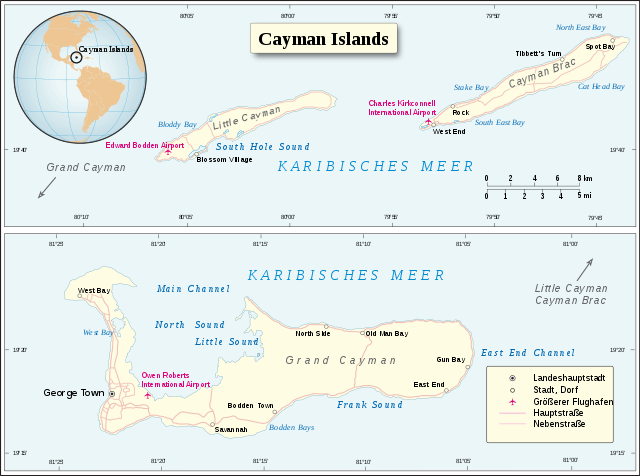
Deutsch: Karte der Cayman Islands (Juni 2016).
English: Map of Cayman Islands (June 2016). |
|||
| Date | ||||
| Source | UN Cartographic Section | |||
| Author | Furfur | |||
| Permission (Reusing this file) |
|
|||
| SVG development | This map was created with Adobe Illustrator. |

File history
Click on a date/time to view the file as it appeared at that time.
| Date/Time | Thumbnail | Dimensions | User | Comment | |
|---|---|---|---|---|---|
| current | 14:00, 14 October 2018 | | 903 × 671 (2.34 MB) | Furfur (talk | contribs) | Kosmetik |
| 13:42, 14 October 2018 |  | 903 × 671 (2.34 MB) | Furfur (talk | contribs) | == {{int:filedesc}} == {{Information |Description={{User:Medium69/Traduction}} {{de|1=Karte der ''Cayman Islands'' (Juni 2016).}} {{en|1=Map of Cayman Islands (June 2016).}} |Source=UN Cartographic Section |Date=2018-10-14 |Author={{U|Furfur}} |Permission={{UN map}} |Other versions= |Other fields={{Igen|A|+|%|s=m}} }} Category:SVG maps of the Caribbean Category:Maps of the Cayman Islands Category:SVG maps in German |
You cannot overwrite this file.
File usage on Commons
There are no pages that use this file.
File usage on other wikis
The following other wikis use this file:
- Usage on de.wikipedia.org
- Usage on fi.wikipedia.org