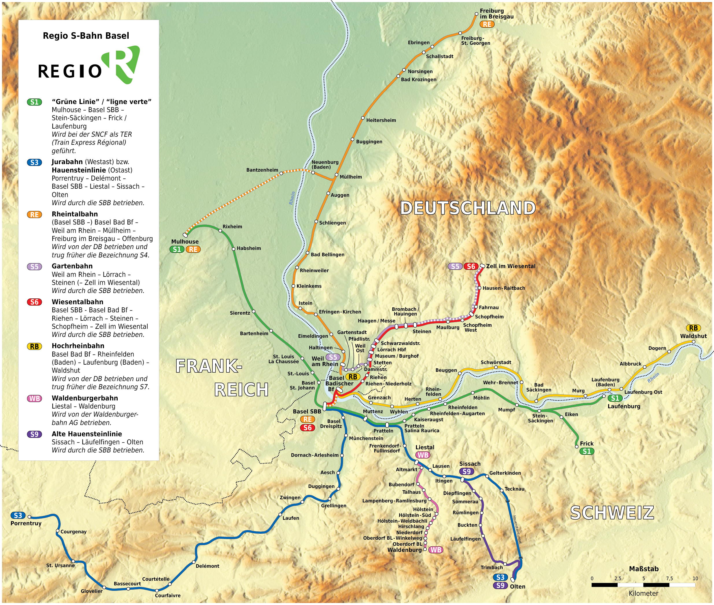
File:Basel - Regio-S-Bahn Basel - Netzplan (mit Hintergrund).jpg
Jump to navigation
Jump to search
Size of this preview: 707 × 599 pixels. Other resolutions: 283 × 240 pixels | 566 × 480 pixels | 906 × 768 pixels | 1,208 × 1,024 pixels | 2,470 × 2,094 pixels.
Original file (2,470 × 2,094 pixels, file size: 3.77 MB, MIME type: image/jpeg)
Captions
Captions
Add a one-line explanation of what this file represents
Summary
[edit]| Description |
|
|
| Date | ||
| Source |
Own work The topological background was taken from www.maps-for-free.com, the Regio S-Bahn logo was reworked by myself. |
|
| Author | Maximilian Dörrbecker (Chumwa) | |
| Permission (Reusing this file) |
I, the copyright holder of this work, hereby publish it under the following license: This file is licensed under the Creative Commons Attribution-Share Alike 2.5 Generic license.
Sie dürfen das Bild zu den folgenden Bedingungen nutzen:
|
|
| Other versions |
|

.jpg)


|
This transport map image could be re-created using vector graphics as an SVG file. This has several advantages; see Commons:Media for cleanup for more information. If an SVG form of this image is available, please upload it and afterwards replace this template with
{{vector version available|new image name}}.
It is recommended to name the SVG file “Basel - Regio-S-Bahn Basel - Netzplan (mit Hintergrund).svg”—then the template Vector version available (or Vva) does not need the new image name parameter. |


.jpg&action=edit§ion=1)
File history
Click on a date/time to view the file as it appeared at that time.
| Date/Time | Thumbnail | Dimensions | User | Comment | |
|---|---|---|---|---|---|
| current | 06:03, 5 August 2016 | | 2,470 × 2,094 (3.77 MB) | Chumwa (talk | contribs) | Verbindung Müllheim - Mulhouse, Verlängerung Verstärkerzüge S5 |
| 07:38, 2 January 2010 |  | 2,470 × 2,094 (1.91 MB) | Chumwa (talk | contribs) | Typo: Besse → Messe | |
| 07:10, 25 December 2009 |  | 2,470 × 2,094 (1.91 MB) | Chumwa (talk | contribs) | update | |
| 05:44, 30 May 2009 |  | 2,471 × 2,094 (885 KB) | Chumwa (talk | contribs) | Waldenburgerbahn hinzugefügt und Haltestellen Pratteln Salina Raurica und Rheinfelden Augarten ergänzt (Danke an Dimelina für die Hinweise!. | |
| 23:25, 26 March 2008 |  | 2,471 × 2,094 (1.71 MB) | Chumwa (talk | contribs) | Nochmal drei Korrekturanmerkungen von de:User:Samoehrle eingearbeitet (danke hierfür!). | |
| 21:20, 25 March 2008 |  | 2,471 × 2,094 (3.36 MB) | Chumwa (talk | contribs) | Fehlerhinweise von Mistaby und Samoehrle eingearbeitet (Einmeldingen -> Eimeldingen, Elken -> Eiken, S5 nur als Spitzenverstärker bis Schopfheim). | |
| 06:10, 14 March 2008 |  | 2,471 × 2,094 (3.36 MB) | Chumwa (talk | contribs) | Linienende der S5 korrigiert (Danke an Stephan für den Fehlerhinweis!) | |
| 05:51, 11 March 2008 |  | 2,471 × 2,094 (3.36 MB) | Chumwa (talk | contribs) | Grenzenlinien vereinheitlicht und anders dargestellt, Layer mit Umriss des Kantons Basel-Land herausgenommen, diverse kleinere Verbesserungen. | |
| 08:34, 9 March 2008 |  | 2,471 × 2,094 (3.31 MB) | Chumwa (talk | contribs) | Auflösung verringert, um die abartige Dateigröße zu reduzieren. | |
| 01:27, 9 March 2008 |  | 4,941 × 4,187 (10.03 MB) | Chumwa (talk | contribs) | {{Information |Description= *{{ de }} Karte: Netzplan der Regio S-Bahn Basel *{{ en }} Map: Basel Regio S-Bahn network *{{ fr }} Plan: Réseau du Regio S-Bahn de Bâle |Source=Self made The topological backround was taken from [www.maps-for-free.com], th |
You cannot overwrite this file.
File usage on Commons
The following 10 pages use this file:
- Basel
- User:Chumwa/Gallery
- User:Chumwa/OgreBot/Potential transport maps/2016 August 1-10
- User:Chumwa/OgreBot/Public transport information/2016 August 1-10
- User:Chumwa/OgreBot/Transport Maps/2016 August 1-10
- User:Chumwa/OgreBot/Travel and communication maps/2016 August 1-10
- User:Flominator/FR/2016 August 1-10
- File:Basel - Regio-S-Bahn Basel - Netzplan.jpg
- File:Basel - Regio-S-Bahn Basel - Netzplan (mit Hintergrund).jpg
- Category:Gartenbahn
File usage on other wikis
The following other wikis use this file:
- Usage on als.wikipedia.org
- Usage on azb.wikipedia.org
- Usage on de.wikipedia.org
- Usage on www.wikidata.org
.jpg&oldid=817798753)