File:Atlas Van der Hagen-KW1049B10 089-HASSIA Landgraviatus.jpeg
Jump to navigation
Jump to search

Size of this preview: 748 × 600 pixels. Other resolutions: 299 × 240 pixels | 599 × 480 pixels | 958 × 768 pixels | 1,277 × 1,024 pixels | 2,554 × 2,048 pixels | 5,500 × 4,410 pixels.
Original file (5,500 × 4,410 pixels, file size: 4.89 MB, MIME type: image/jpeg)
Captions
Captions
Add a one-line explanation of what this file represents
Summary
[edit]| Dirk Jansz van Santen: Atlas van Dirk van der Hagen (volledig, collectie KB)
|
|||||||||||||||||||||||||||||
|---|---|---|---|---|---|---|---|---|---|---|---|---|---|---|---|---|---|---|---|---|---|---|---|---|---|---|---|---|---|
| Artist |
|
 | |||||||||||||||||||||||||||
| Author |
Publisher:
|
||||||||||||||||||||||||||||
| Title |
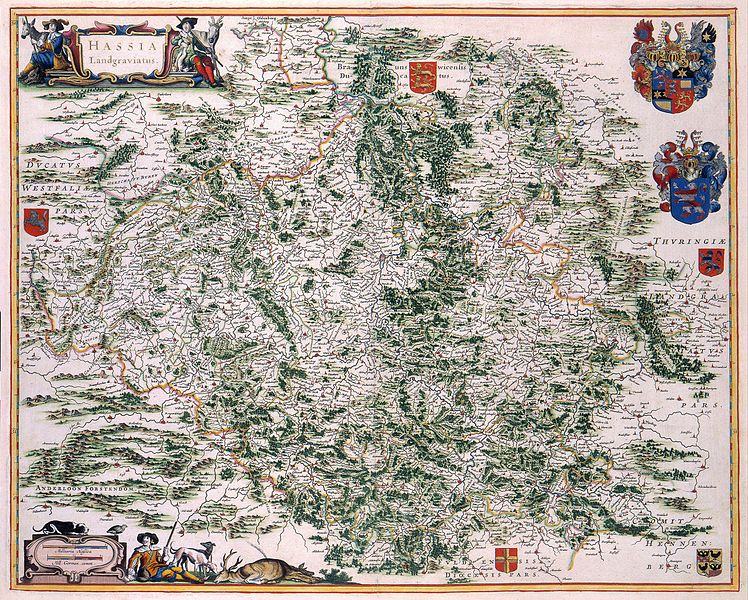
HASSIA Landgraviatus |
||||||||||||||||||||||||||||
| Object type | map | ||||||||||||||||||||||||||||
| Description |
Nederlands: De eerste gedrukte kaarten van Hessen verschenen in Sebastiaan Münsters Cosmographia (1550) en Abraham Ortelius (1527-1598) Theatrum Orbis Terrarum (1575). Deze kaarten gaan terug op het werk van J. Dryander. De 17de eeuwse kaarten waren vooral gebaseerd op een topografische opname van Hessen die in 1607-1617 werd uitgevoerd door Wilhelm Dilich (1571-1655) in opdracht van Landgraaf Moritz van Hessen. Hieruit resulteerden 27 kaarten van het gebied. Deze versie van de kaart werd vermoedelijk gepubliceerd door Joan Blaeu (1598-1673).
English: The first maps of Hessen appeared in Sebastian Münsters Cosmographia (1550) and Abraham Ortelius (1527-1598) Theatrum Orbis Terrarum (1575). These maps were based on the work by J. Dryander. 17th-century maps were mainly based on the topographical survey of Hessen carried out between 1607-1617 by Wilhelm Dilich (1571-1655) ordered by the landgrave Moritz van Hessen. The survey resulted in 27 maps. This version of the map was probable published by Joan Blaeu (1598-1673). |
||||||||||||||||||||||||||||
| Language |
Dutch |
||||||||||||||||||||||||||||
| Date | 1662 | ||||||||||||||||||||||||||||
| Publication date |
circa |
||||||||||||||||||||||||||||
| Medium |
Nederlands: kopergravure
English: copper engraving print |
||||||||||||||||||||||||||||
| Dimensions | 45 x 55 cm | ||||||||||||||||||||||||||||
| Collection |
|
||||||||||||||||||||||||||||
| Accession number |
Description of the Atlas Van der Hagen in the catalogue of the KB: http://opc4.kb.nl/DB=1/TTL=1/LNG=EN/PPN?PPN=353012750 |
||||||||||||||||||||||||||||
| Place of creation | Amsterdam | ||||||||||||||||||||||||||||
| Notes | KW1049B10_089 - Volume 1 | ||||||||||||||||||||||||||||
| Related persons | Joan Blaeu - Münster, Sebastiaan - Abraham Ortelius - Dillich, Wilhelm - Dryander, J. - Hessen, Moritz von | ||||||||||||||||||||||||||||
| Depicted locations | Hessen - Germany | ||||||||||||||||||||||||||||
| References | |||||||||||||||||||||||||||||
| Source/Photographer |
Source page at the Geheugen van Nederland / Memory of the Netherlands website.
|
||||||||||||||||||||||||||||
| Permission (Reusing this file) |
|
||||||||||||||||||||||||||||
.jpg)

File history
Click on a date/time to view the file as it appeared at that time.
| Date/Time | Thumbnail | Dimensions | User | Comment | |
|---|---|---|---|---|---|
| current | 22:13, 18 July 2015 | | 5,500 × 4,410 (4.89 MB) | OlafJanssen (talk | contribs) | GWToolset: Creating mediafile for OlafJanssen. |
You cannot overwrite this file.
File usage on Commons
The following 4 pages use this file:
File usage on other wikis
The following other wikis use this file:
- Usage on de.wikipedia.org