File:Atlas Van der Hagen-KW1049B10 086-ARCHIEPISCOPATUS et ELECTORATUS MOGUNTINI et adjacentium Regionum, ut LANDGRAVIATUM HASSO DARMSTADIENSIS et RHENOFELDENSIS, COMITATUUM HANNOVIENSIS.jpeg
Jump to navigation
Jump to search

Size of this preview: 722 × 600 pixels. Other resolutions: 289 × 240 pixels | 578 × 480 pixels | 925 × 768 pixels | 1,233 × 1,024 pixels | 2,466 × 2,048 pixels | 5,500 × 4,568 pixels.
Original file (5,500 × 4,568 pixels, file size: 4.91 MB, MIME type: image/jpeg)
Captions
Captions
Add a one-line explanation of what this file represents
Summary
[edit]| Dirk Jansz van Santen: Atlas van Dirk van der Hagen (volledig, collectie KB)
|
|||||||||||||||||||||||||||
|---|---|---|---|---|---|---|---|---|---|---|---|---|---|---|---|---|---|---|---|---|---|---|---|---|---|---|---|
| Artist |
Author: per Fredericum de Wit Amstelodami Publisher: F. de Wit cum Privilegio Ordinum Hollandiae et Westfrisiae |
 | |||||||||||||||||||||||||
| Author |
Author: per Fredericum de Wit Amstelodami Publisher: F. de Wit cum Privilegio Ordinum Hollandiae et Westfrisiae |
||||||||||||||||||||||||||
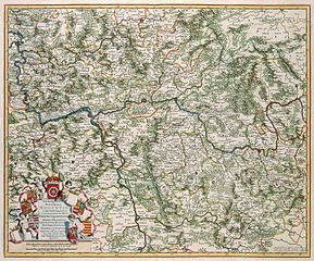
| Title |
ARCHIEPISCOPATUS et ELECTORATUS MOGUNTINI et adjacentium Regionum, ut LANDGRAVIATUM HASSO DARMSTADIENSIS et RHENOFELDENSIS, COMITATUUM HANNOVIENSIS |
||||||||||||||||||||||||||
| Object type | map | ||||||||||||||||||||||||||
| Description |
Nederlands: Deze kaart van het aartsbisdom en keurvorstendom Mannheim werd uitgegeven door Frederik de Wit (1630-1706). De bron waaraan hij zijn informatie ontleende is niet bekend.
English: This map of the arch episcopality and electorate Mannheim was published by Frederik de Wit (1630-1706). Its source is unknown. |
||||||||||||||||||||||||||
| Language |
Dutch |
||||||||||||||||||||||||||
| Date | after 1688 | ||||||||||||||||||||||||||
| Publication date |
circa |
||||||||||||||||||||||||||
| Medium |
Nederlands: kopergravure
English: copper engraving print |
||||||||||||||||||||||||||
| Dimensions | 49 x 60 cm | ||||||||||||||||||||||||||
| Collection |
|
||||||||||||||||||||||||||
| Accession number |
Description of the Atlas Van der Hagen in the catalogue of the KB: http://opc4.kb.nl/DB=1/TTL=1/LNG=EN/PPN?PPN=353012750 |
||||||||||||||||||||||||||
| Place of creation |
Netherlands |
||||||||||||||||||||||||||
| Notes | KW1049B10_086 - Volume 1 | ||||||||||||||||||||||||||
| Related persons | Frederik de Wit | ||||||||||||||||||||||||||
| Depicted locations | Germany - Mannheim (electorate) - Mannheim (arch episcopality) - Darmstadt - Frankfurt am Main | ||||||||||||||||||||||||||
| References | |||||||||||||||||||||||||||
| Source/Photographer |
Source page at the Geheugen van Nederland / Memory of the Netherlands website.
|
||||||||||||||||||||||||||
| Permission (Reusing this file) |
|
||||||||||||||||||||||||||

File history
Click on a date/time to view the file as it appeared at that time.
| Date/Time | Thumbnail | Dimensions | User | Comment | |
|---|---|---|---|---|---|
| current | 22:45, 18 July 2015 | | 5,500 × 4,568 (4.91 MB) | OlafJanssen (talk | contribs) | GWToolset: Creating mediafile for OlafJanssen. |
You cannot overwrite this file.
File usage on Commons
The following 3 pages use this file: