File:Atlas Van der Hagen-KW1049B10 070-Nova totius WESTPHALIAE.jpeg
Jump to navigation
Jump to search

Size of this preview: 682 × 600 pixels. Other resolutions: 273 × 240 pixels | 546 × 480 pixels | 874 × 768 pixels | 1,165 × 1,024 pixels | 2,329 × 2,048 pixels | 5,500 × 4,836 pixels.
Original file (5,500 × 4,836 pixels, file size: 4.84 MB, MIME type: image/jpeg)
Captions
Captions
Add a one-line explanation of what this file represents
Summary[edit]
| Dirk Jansz van Santen: Atlas van Dirk van der Hagen (volledig, collectie KB)
|
|||||||||||||||||||||||||||
|---|---|---|---|---|---|---|---|---|---|---|---|---|---|---|---|---|---|---|---|---|---|---|---|---|---|---|---|
| Artist |
Author: emendata a F: de Wit Publisher: Frederick de Wit inde Calverstraet by den Dam inde Witte Paskaert |
 | |||||||||||||||||||||||||
| Author |
Author: emendata a F: de Wit Publisher: Frederick de Wit inde Calverstraet by den Dam inde Witte Paskaert |
||||||||||||||||||||||||||
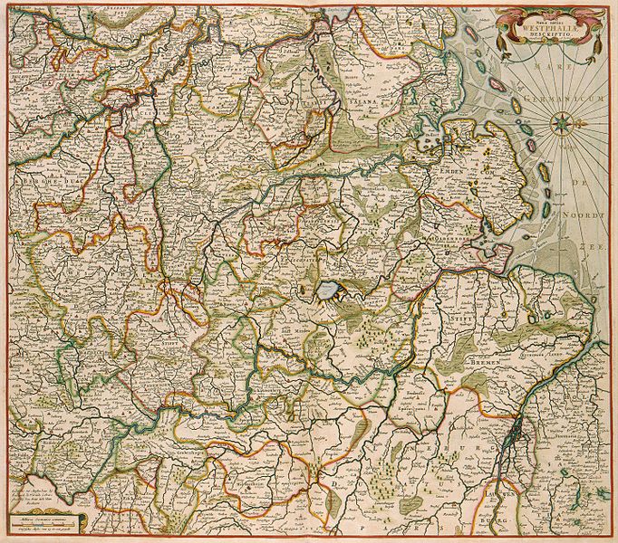
| Title |
Nova totius WESTPHALIAE |
||||||||||||||||||||||||||
| Object type | map | ||||||||||||||||||||||||||
| Description |
Nederlands: Deze kaart van Westfalen werd uitgegeven door Frederik de Wit (1630-1706). Als bron voor de kaart greep De Wit terug op een kaart van Gerardus Mercator (1512-1594) uit 1575, en op een serie van 7 kaarten die Johannes Gigas (1580/82-1633) in 1620 in Keulen publiceerde. Deze beide kaarten werden tot het midden van de 18de eeuw alle belangrijke Amsterdamse uitgevers gebruikt.
English: This map of Westfalen was published by Frederik de Wit (1630-1706). De Wit based his map on the one by Gerardus Mercator (1512-1594) of 1575, which was part of a series of 7 maps published in Cologne by Johannes Gigas (1580/82-1633) in 1620. Both maps were used by Amsterdam publishing houses until mid-18th century. |
||||||||||||||||||||||||||
| Language |
Dutch |
||||||||||||||||||||||||||
| Date | after 1688 | ||||||||||||||||||||||||||
| Publication date |
circa |
||||||||||||||||||||||||||
| Medium |
Nederlands: kopergravure
English: copper engraving print |
||||||||||||||||||||||||||
| Dimensions | 47 x 54 cm | ||||||||||||||||||||||||||
| Collection |
|
||||||||||||||||||||||||||
| Accession number |
Description of the Atlas Van der Hagen in the catalogue of the KB: http://opc4.kb.nl/DB=1/TTL=1/LNG=EN/PPN?PPN=353012750 |
||||||||||||||||||||||||||
| Place of creation |
Netherlands |
||||||||||||||||||||||||||
| Notes | KW1049B10_070 - Volume 1 | ||||||||||||||||||||||||||
| Related persons | Frederik de Wit - Gerardus Mercator - Gigas, Johannes | ||||||||||||||||||||||||||
| Depicted locations | Westfalen - Germany | ||||||||||||||||||||||||||
| References | |||||||||||||||||||||||||||
| Source/Photographer |
Source page at the Geheugen van Nederland / Memory of the Netherlands website.
|
||||||||||||||||||||||||||
| Permission (Reusing this file) |
|
||||||||||||||||||||||||||

File history
Click on a date/time to view the file as it appeared at that time.
| Date/Time | Thumbnail | Dimensions | User | Comment | |
|---|---|---|---|---|---|
| current | 23:58, 18 July 2015 | | 5,500 × 4,836 (4.84 MB) | OlafJanssen (talk | contribs) | GWToolset: Creating mediafile for OlafJanssen. |
You cannot overwrite this file.
File usage on Commons
The following 3 pages use this file:
File usage on other wikis
The following other wikis use this file:
- Usage on de.wikipedia.org