File:Atlas Van der Hagen-KW1049B10 053-SILESIA DVCATVS.jpeg
Jump to navigation
Jump to search
Size of this preview: 768 × 599 pixels. Other resolutions: 308 × 240 pixels | 615 × 480 pixels | 984 × 768 pixels | 1,280 × 999 pixels | 2,560 × 1,998 pixels | 5,500 × 4,293 pixels.
Original file (5,500 × 4,293 pixels, file size: 3.17 MB, MIME type: image/jpeg)
Captions
Captions
Add a one-line explanation of what this file represents
Summary
[edit]| Dirk Jansz van Santen: Atlas van Dirk van der Hagen (volledig, collectie KB)
|
||||||||||||||||||||||||||||
|---|---|---|---|---|---|---|---|---|---|---|---|---|---|---|---|---|---|---|---|---|---|---|---|---|---|---|---|---|
| Artist |
A Martino Helwigio Nissense descriptus Author: A Martino Helwigio Nissense descriptus Publisher:
|
 | ||||||||||||||||||||||||||
| Title |
SILESIA DVCATVS |
|||||||||||||||||||||||||||
| Object type | map | |||||||||||||||||||||||||||
| Description |
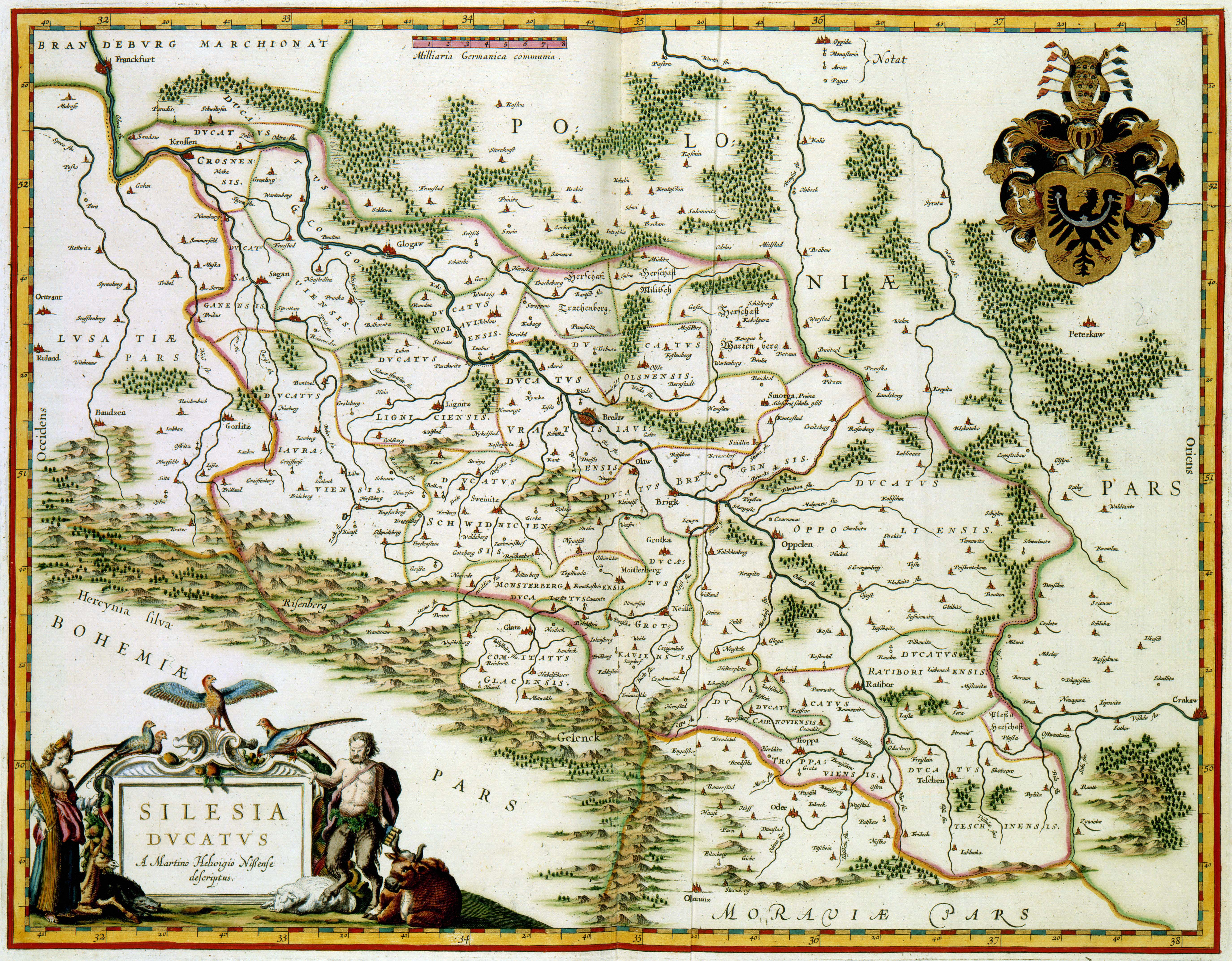
Nederlands: Deze kaart van Silezië werd in 1635 door Willem Jansz. Blaeu (1571-1638) gepubliceerd in zijn Atlas Novus. Als voorbeeld gebruikte Blaeu een 75-jaar oude kaart van de Duitse kartograaf Martin Helwig (1516-1574). Diens houtgravure van Silesie werd al in 1561 uitgegeven. Deze kaart werd ook door andere Nederlandse kartografen als Abraham Ortelius (1527-1598), Gerard de Jode (1509-1591) en Jan Janssonius (1588-1664) als bron voor hun kaarten gebruikt.
English: This map of Silezia was published in 1635 by Willem Jansz. Blaeu (1571-1638) in his Atlas Novus. Blaeu based the map on the 75-year old example of the German cartographer Martin Helwig (1516-1574). This map was also used by other Dutch cartographers such as Abraham Ortelius (1527-1598), Gerard de Jode (1509-1591) and Jan Janssonius (1588-1664). |
|||||||||||||||||||||||||||
| Language |
Dutch |
|||||||||||||||||||||||||||
| Date | 1635 | |||||||||||||||||||||||||||
| Publication date |
circa |
|||||||||||||||||||||||||||
| Medium |
Nederlands: kopergravure
English: copper engraving print |
|||||||||||||||||||||||||||
| Dimensions | 38,5 x 50 cm | |||||||||||||||||||||||||||
| Collection |
|
|||||||||||||||||||||||||||
| Accession number |
Description of the Atlas Van der Hagen in the catalogue of the KB: http://opc4.kb.nl/DB=1/TTL=1/LNG=EN/PPN?PPN=353012750 |
|||||||||||||||||||||||||||
| Place of creation | Amsterdam | |||||||||||||||||||||||||||
| Notes | KW1049B10_053 - Volume 1 | |||||||||||||||||||||||||||
| Related persons | Helwig, Martin - Willem Jansz. Blaeu - Abraham Ortelius - Gerard de Jode - Jan Janssonius | |||||||||||||||||||||||||||
| Depicted locations | Silezia | |||||||||||||||||||||||||||
| References | ||||||||||||||||||||||||||||
| Source/Photographer |
Source page at the Geheugen van Nederland / Memory of the Netherlands website.
|
|||||||||||||||||||||||||||


Licensing
[edit]
|
This is a faithful photographic reproduction of a two-dimensional, public domain work of art. The work of art itself is in the public domain for the following reason:
The official position taken by the Wikimedia Foundation is that "faithful reproductions of two-dimensional public domain works of art are public domain".
This photographic reproduction is therefore also considered to be in the public domain in the United States. In other jurisdictions, re-use of this content may be restricted; see Reuse of PD-Art photographs for details. | ||||
File history
Click on a date/time to view the file as it appeared at that time.
| Date/Time | Thumbnail | Dimensions | User | Comment | |
|---|---|---|---|---|---|
| current | 02:22, 19 July 2015 | | 5,500 × 4,293 (3.17 MB) | OlafJanssen (talk | contribs) | GWToolset: Creating mediafile for OlafJanssen. |
You cannot overwrite this file.
File usage on Commons
The following 3 pages use this file: