File:Atlas Van der Hagen-KW1049B10 006-EUROPA delineata et recens edita.jpeg
Jump to navigation
Jump to search

Size of this preview: 745 × 599 pixels. Other resolutions: 298 × 240 pixels | 597 × 480 pixels | 955 × 768 pixels | 1,273 × 1,024 pixels | 2,546 × 2,048 pixels | 5,500 × 4,425 pixels.
Original file (5,500 × 4,425 pixels, file size: 3.93 MB, MIME type: image/jpeg)
Captions
Captions
Add a one-line explanation of what this file represents
Summary[edit]
| Dirk Jansz van Santen: Atlas van Dirk van der Hagen (volledig, collectie KB)
|
|||||||||||||||||||||||||||
|---|---|---|---|---|---|---|---|---|---|---|---|---|---|---|---|---|---|---|---|---|---|---|---|---|---|---|---|
| Artist |
|
 | |||||||||||||||||||||||||
| Author |
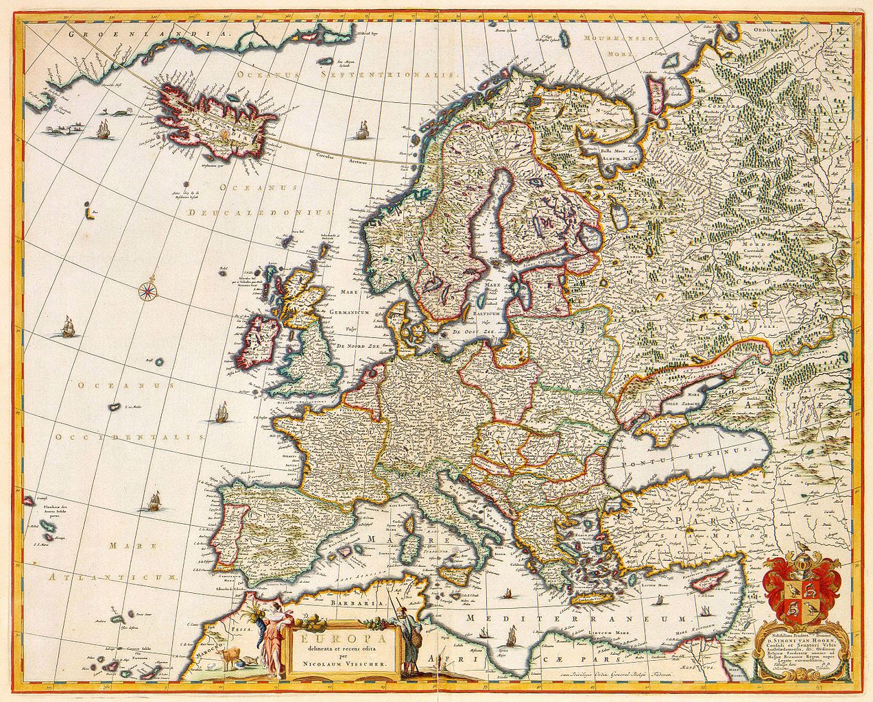
Author and publisher: Nicolaes Visscher II |
||||||||||||||||||||||||||
| Title |
EUROPA delineata et recens edita |
||||||||||||||||||||||||||
| Object type | map | ||||||||||||||||||||||||||
| Description |
Nederlands: Deze kaart van Europa werd gepubliceerd door Nicolaes Visscher I (1618-1679), of door zijn zoon Nicolaes Visscher II (1649-1702). Zon Europa-kaart hoorde in elke 17de-eeuwse atlas thuis. Vaak diende zon kaart als een soort bladwijzer, met behulp waarvan de detailkaarten van Europese landen en streken in een groot geografisch verband konden worden geplaatst. Dat betekende niet dat zon kaart ook altijd een betrouwbaar beeld gaf. Grote gebieden in noord- en oost Europa werden bijvoorbeeld nauwelijks bereisd, terwijl anderzijds de vele oorlogen die op het vasteland werden uitgevochten het vaak onmogelijk maakten de landsgrenzen actueel aan te geven.; Rechtsonder een opdracht van Nicolaes Visscher II aan Simon van Hoorn.
English: This map of Europe was published by the Amsterdam publisher Nicolaes Visscher I (1618-1679), or by his son Nicolaes Visscher II (1649-1702). A map of Europe belonged in each 17th century atlas. Such a map often served as a kind of index for searching detailed maps of European countries in a greater geographical context. Therefore, such maps were not always depicting a reliable image of an area. Large areas in northern and southern Europe for example, were hardly explored, while on the other hand many wars and battles on the main land made it difficult to establish actual border lines. |
||||||||||||||||||||||||||
| Language |
Dutch |
||||||||||||||||||||||||||
| Date |
Nederlands: voor 1680
English: before 1680 |
||||||||||||||||||||||||||
| Publication date |
circa |
||||||||||||||||||||||||||
| Medium |
Nederlands: kopergravure
English: copper engraving print |
||||||||||||||||||||||||||
| Dimensions | 43,5 x 54 cm | ||||||||||||||||||||||||||
| Collection |
|
||||||||||||||||||||||||||
| Accession number |
Description of the Atlas Van der Hagen in the catalogue of the KB: http://opc4.kb.nl/DB=1/TTL=1/LNG=EN/PPN?PPN=353012750 |
||||||||||||||||||||||||||
| Place of creation | Amsterdam | ||||||||||||||||||||||||||
| Notes | KW1049B10_006 - Volume 1 | ||||||||||||||||||||||||||
| Related persons | Nicolaes Visscher II - Simon van Hoorn | ||||||||||||||||||||||||||
| Depicted locations | Europe | ||||||||||||||||||||||||||
| References | |||||||||||||||||||||||||||
| Source/Photographer |
Source page at the Geheugen van Nederland / Memory of the Netherlands website.
|
||||||||||||||||||||||||||

Licensing[edit]
|
This is a faithful photographic reproduction of a two-dimensional, public domain work of art. The work of art itself is in the public domain for the following reason:
The official position taken by the Wikimedia Foundation is that "faithful reproductions of two-dimensional public domain works of art are public domain".
This photographic reproduction is therefore also considered to be in the public domain in the United States. In other jurisdictions, re-use of this content may be restricted; see Reuse of PD-Art photographs for details. | ||||
File history
Click on a date/time to view the file as it appeared at that time.
| Date/Time | Thumbnail | Dimensions | User | Comment | |
|---|---|---|---|---|---|
| current | 09:01, 19 July 2015 | | 5,500 × 4,425 (3.93 MB) | OlafJanssen (talk | contribs) | GWToolset: Creating mediafile for OlafJanssen. |
You cannot overwrite this file.
File usage on Commons
The following 3 pages use this file:
File usage on other wikis
The following other wikis use this file:
- Usage on lt.wikipedia.org
- Usage on nl.wikipedia.org
- Usage on pl.wikipedia.org