File:Aerial photograph of Midway Atoll on 24 November 1941 (80-G-451086).jpg
Jump to navigation
Jump to search

Size of this preview: 792 × 600 pixels. Other resolutions: 317 × 240 pixels | 634 × 480 pixels | 1,014 × 768 pixels | 1,280 × 969 pixels | 2,560 × 1,939 pixels | 4,526 × 3,428 pixels.
Original file (4,526 × 3,428 pixels, file size: 6.09 MB, MIME type: image/jpeg)
Captions
Captions
Add a one-line explanation of what this file represents
Summary
[edit].jpg&action=edit§ion=1)
| Photographer |
Unknown author |
||||||||||||||||||||
| Description |
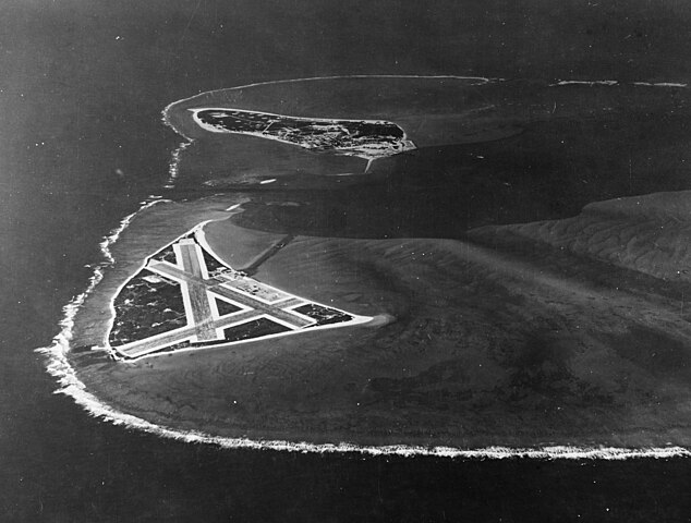
English: Aerial photograph of Midway Atoll, looking just south of west across the southern side of the atoll, 24 November 1941. Eastern Island, then the site of Midway's airfield, is in the foreground. Sand Island, location of most other base facilities, is across the entrance channel. |
||||||||||||||||||||
| Depicted place | Midway Atoll | ||||||||||||||||||||
| Date | 24 November 1941 | ||||||||||||||||||||
| Collection |
|
||||||||||||||||||||
| Accession number |
80-G-451086 |
||||||||||||||||||||
| Source | U.S. Navy photo 80-G-451086 | ||||||||||||||||||||
| Other versions | File:Aerial view of Midway Atoll on 24 November 1941 (80-G-451086).jpg | ||||||||||||||||||||
.jpg)
Licensing
[edit].jpg&action=edit§ion=2)
| This image is available from the Naval History and Heritage Command under the digital ID 80-G-451086. Most of the photos found in the NHHC collection are in the public domain and may be downloaded and used without permissions or special requirements. Those which are not will be noted in the copyright section of the NHHC image description.[1] |
This file is a work of a sailor or employee of the U.S. Navy, taken or made as part of that person's official duties. As a work of the U.S. federal government, it is in the public domain in the United States.
|
 | |
| This file has been identified as being free of known restrictions under copyright law, including all related and neighboring rights. | ||
File history
Click on a date/time to view the file as it appeared at that time.
| Date/Time | Thumbnail | Dimensions | User | Comment | |
|---|---|---|---|---|---|
| current | 21:42, 28 October 2015 | | 4,526 × 3,428 (6.09 MB) | Cobatfor (talk | contribs) | new NHHC file |
| 21:58, 9 February 2012 |  | 680 × 740 (333 KB) | Cobatfor (talk | contribs) | caption bar cropped | |
| 13:21, 22 May 2006 |  | 680 × 765 (127 KB) | Ulflarsen (talk | contribs) | Caption: Midway Atoll. Aerial photograph, looking just south of west across the southern side of the atoll, 24 November 1941. Eastern Island, then the site of Midway's airfield, is in the foreground. Sand Island, location of most other base facilities, is |
You cannot overwrite this file.
File usage on Commons
The following 7 pages use this file:
- Battle of Midway
- User:Holly Cheng/Recent uploads/Hawaii/2015 October 28
- User:OgreBot/Watercraft/2015 October 27-31
- Commons:WikiProject Aviation/recent uploads/2015 October 28
- File:Aerial photograph of Midway Atoll on 24 November 1941 (80-G-451086).jpg
- File:G451086 Midway Island US Pacific november 1941.jpg (file redirect)
.jpg)
File usage on other wikis
The following other wikis use this file:
- Usage on da.wikipedia.org
- Usage on el.wikipedia.org
- Usage on it.wikipedia.org
- Usage on nl.wikipedia.org
- Usage on pl.wikipedia.org
.jpg&oldid=782629223)