File:Aerial View - Landschaft Markgräflerland1.jpg

Original file (3,252 × 2,154 pixels, file size: 6.77 MB, MIME type: image/jpeg)
Captions
Captions
Summary
[edit]
| Description |
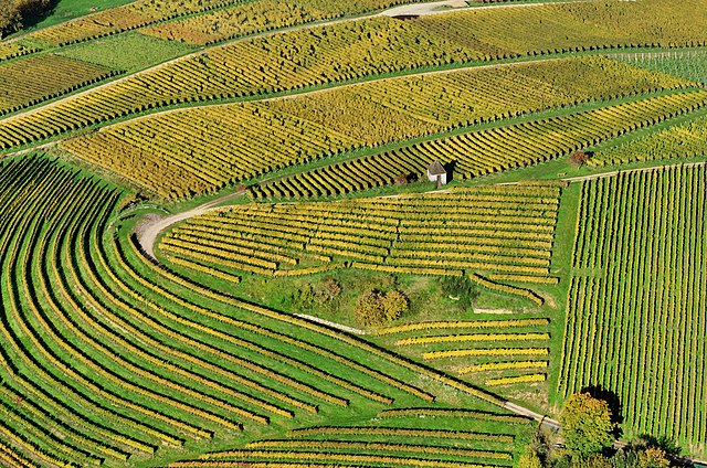
English: Aerial view of vineyards at Markgräflerland
Deutsch: Luftbild einer Weinbergfläche im Markgräflerland |
||
| Date | Taken on 21 October 2012 | ||
| Source | Own work | ||
| Author | Taxiarchos228 | ||
| Permission (Reusing this file) |
|
||
| Other versions | Derivative works of this file: Aerial View - Landschaft Markgräflerland (crop).jpg |
.jpg)
| Object location | | View this and other nearby images on: OpenStreetMap |
|---|
Assessment
[edit]
|
This image was selected as picture of the day on Wikimedia Commons for 10 February 2014. It was captioned as follows: English: Aerial view of vineyards at Markgräflerland Other languages:
Bosanski: Panoramski pogled na vinograde u oblasti Markgräflerland, Baden-Württemberg Deutsch: Luftbild einer Weinbergfläche im Markgräflerland English: Aerial view of vineyards at Markgräflerland Magyar: Markgräflerlandi szőlőültetvények légifelvételen (Németország, Baden-Württemberg) Nederlands: Luchtfoto van de wijngaarden van Markgräflerland, een streek in het zuidwesten van Duitsland in de deelstaat Baden-Württemberg. 中文: 鸟瞰德国马克格雷夫莱兰德的葡萄园。 |
Licensing
[edit]

|
Permission is granted to copy, distribute and/or modify this document under the terms of the GNU Free Documentation License, Version 1.2 or any later version published by the Free Software Foundation; with no Invariant Sections, no Front-Cover Texts, and no Back-Cover Texts. A copy of the license is included in the section entitled GNU Free Documentation License. |
- You are free:
- to share – to copy, distribute and transmit the work
- to remix – to adapt the work
- Under the following conditions:
- attribution – You must give appropriate credit, provide a link to the license, and indicate if changes were made. You may do so in any reasonable manner, but not in any way that suggests the licensor endorses you or your use.
 Bilder des zentralen Medienarchivs Wikimedia Commons, unterstehen einer Freien Lizenz. Diese Freiheit bedeutet nicht, dass dadurch das Urheberrecht entfällt. Ganz im Gegenteil: Als Gegenleistung für die kostenlose (nichtgewerbliche) Nutzung muss der Weiternutzer nur die Lizenzbedingungen einhalten und den Fotografen (meinen vollständigen Klarnamen Wladyslaw Sojka sowie die verlinkte Website www.sojka.photo) als Urheber nennen. Juristisch ist die unterlassene Namensnennung eine Urheberrechtsverletzung bzw. eine Verletzung der Urheberpersönlichkeitsrechte. Als Urheber kann ich mich gegen Bilderklau wehren, in dem ich einen Strafantrag stelle oder unmittelbar einen Rechtsanwalt beauftrage. Die Folge ist eine Abmahnung und die Aufforderung, eine strafbewehrte Unterlassungserklärung abzugeben. So weit sollte es nicht kommen. Bitte achten Sie auf diese Regeln oder kontaktieren Sie mich im Zweifelsfall. Sollten Abweichungen von den hier angegebenen Regeln erwünscht sein, dann bedarf es auf jeden Fall einer ausdrücklichen Genehmigung von mir als Urheber des jeweiligen Bildes. Kontaktmöglichkeiten: über Wikimedia Commons oder über www.sojka.photo. |
File history
Click on a date/time to view the file as it appeared at that time.
| Date/Time | Thumbnail | Dimensions | User | Comment | |
|---|---|---|---|---|---|
| current | 05:53, 5 November 2012 | | 3,252 × 2,154 (6.77 MB) | Taxiarchos228 (talk | contribs) | {{Information |Description ={{en|1=Aerial view of vineyards at Markgräflerland}} {{de|1=Luftbild vom von einer Weinbergregion im Markgräflerland}} |Source ={{own}} |Author =Taxiarchos228 |Date =2012... |
You cannot overwrite this file.
File usage on Commons
The following 35 pages use this file:
- Landscape
- User:Taxiarchos228/Pics/Germany
- User:Taxiarchos228/QICpromoted/Part 4
- User:Taxiarchos228/featured picture
- User:Ö/Best/2012
- Commons:Featured picture candidates/File:Aerial View - Landschaft Markgräflerland1.jpg
- Commons:Featured picture candidates/Log/November 2012
- Commons:Featured pictures/Places/Agriculture
- Commons:Featured pictures/chronological/2012-B
- Commons:Files used on the OpenStreetMap Wiki/2
- Commons:Picture of the Year/2012/Galleries/2012-B
- Commons:Picture of the Year/2012/Galleries/ALL
- Commons:Picture of the Year/2012/Galleries/Index/16
- Commons:Picture of the Year/2012/Galleries/NOV
- Commons:Picture of the Year/2012/Galleries/Nature views
- Commons:Picture of the Year/2012/R1/Aerial View - Landschaft Markgräflerland1.jpg
- Commons:Picture of the Year/2012/Results/R1/ALL
- Commons:Picture of the Year/2012/Results/R1/ALL/gallery
- Commons:Picture of the Year/2012/Results/R1/ALL/thumbnailtable
- Commons:Picture of the Year/2012/Results/R1/Nature views
- Commons:Quality images/Subject/Places/Mixed/Archive2
- Commons:Quality images candidates/Archives November 2012
- File:Aerial View - Landschaft Markgräflerland (crop).jpg
- Template:Potd/2014-02
- Template:Potd/2014-02-10
- Template:Potd/2014-02-10 (bs)
- Template:Potd/2014-02-10 (cs)
- Template:Potd/2014-02-10 (de)
- Template:Potd/2014-02-10 (en)
- Template:Potd/2014-02-10 (hu)
- Template:Potd/2014-02-10 (it)
- Template:Potd/2014-02-10 (nl)
- Template:Potd/2014-02-10 (ru)
- Template:Potd/2014-02-10 (zh-hans)
- Template:Potd/2014-02 (zh-hans)
File usage on other wikis
The following other wikis use this file:
- Usage on ar.wikipedia.org
- Usage on be-tarask.wikipedia.org
- Usage on bn.wikipedia.org
- Usage on crh.wikipedia.org
- Usage on cv.wikipedia.org
- Usage on de.wikipedia.org
- Usage on diq.wiktionary.org
- Usage on dsb.wikipedia.org
- Usage on en.wikipedia.org
- Usage on en.wikivoyage.org
- Usage on fa.wikipedia.org
- Usage on fa.wikivoyage.org
- Usage on fr.wikipedia.org
- Usage on fr.wikiquote.org
- Usage on fy.wikipedia.org
- Usage on gom.wikipedia.org
- Usage on hi.wikipedia.org
- Usage on hsb.wikipedia.org
- Usage on hu.wikipedia.org
- Usage on id.wikipedia.org
- Usage on incubator.wikimedia.org
- Usage on it.wikipedia.org
- Usage on ka.wikipedia.org
- Usage on ko.wikipedia.org
- Usage on krc.wikipedia.org
- Usage on lbe.wikipedia.org
- Usage on lb.wikipedia.org
- Usage on nl.wikipedia.org
- Usage on os.wikipedia.org
- Usage on pl.wikipedia.org
- Usage on pt.wikipedia.org
- Usage on ru.wikipedia.org
- Usage on ru.wikinews.org
View more global usage of this file.