File:2019-03-14 CAPITÁIN LEONIDAS - IMO 5542705.jpg
Jump to navigation
Jump to search

Size of this preview: 800 × 534 pixels. Other resolutions: 320 × 214 pixels | 640 × 427 pixels | 1,024 × 684 pixels | 1,280 × 854 pixels | 2,560 × 1,709 pixels | 4,027 × 2,688 pixels.
Original file (4,027 × 2,688 pixels, file size: 8.45 MB, MIME type: image/jpeg)
Captions
Captions
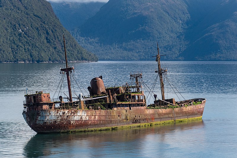
Wreck of cargo ship, CAPITÁN LEONIDAS, that ran aground on April 7, 1968 in the Messier Channel, Chile.
Summary
[edit]
| Description |
English: Wreck of a former cargo ship carrying bagged sugar from Santos, Brazil, the CAPITÁN LEONIDAS - IMO 5427057, ran aground on April 7, 1968 in the fjords of Canal Messier (Messier Channel), north of Angostura Inglesa (English Narrows) and the town of Puerto Eden. Ship is shown on March 14th, 2019, sitting firmly on the flattened top of a submerged mountain called Bajo Cotopaxi (Cotopaxi Bank). Bajo Cotopaxi falls off quickly. The water is 200 meters deep just 100 meters from this wreck positioned at 48°46'19.826" S 74°27'9.606" W.
Originally built in Bremen in 1937 and named the MV Molda. |
| Date | |
| Source | Own work |
| Author | Gordon Leggett |
| Attribution (required by the license) | Photo: Gordon Leggett / Wikimedia Commons / |
| Camera location | | View this and other nearby images on: OpenStreetMap |
|---|
Our Chilean pilots said that the holes in the hull are from the Armada de Chile (Chilean Navy) doing target practice.
Assessment
[edit]
|

|
This image has been assessed under the valued image criteria and is considered the most valued image on Commons within the scope: Capitán Leonidas (ship, 1937) - IMO 5542705. You can see its nomination here. |
Licensing
[edit]
I, the copyright holder of this work, hereby publish it under the following license:
This file is licensed under the Creative Commons Attribution-Share Alike 4.0 International license.
- You are free:
- to share – to copy, distribute and transmit the work
- to remix – to adapt the work
- Under the following conditions:
- attribution – You must give appropriate credit, provide a link to the license, and indicate if changes were made. You may do so in any reasonable manner, but not in any way that suggests the licensor endorses you or your use.
- share alike – If you remix, transform, or build upon the material, you must distribute your contributions under the same or compatible license as the original.
File history
Click on a date/time to view the file as it appeared at that time.
| Date/Time | Thumbnail | Dimensions | User | Comment | |
|---|---|---|---|---|---|
| current | 01:29, 25 March 2019 | | 4,027 × 2,688 (8.45 MB) | GRDN711 (talk | contribs) | User created page with UploadWizard |
You cannot overwrite this file.
File usage on Commons
The following 19 pages use this file:
- User:OgreBot/Watercraft/2019 March 25
- User talk:GRDN711/Archive 2
- Commons:Featured picture candidates/File:2019-03-14 CAPITÁIN LEONIDAS - IMO 5542705.jpg
- Commons:Featured picture candidates/Log/May 2021
- Commons:Featured pictures/Objects/Vehicles/Water transport
- Commons:Featured pictures/chronological/2021-A
- Commons:Featured pictures/chronological/May 2021
- Commons:Picture of the Year/2021/Candidates
- Commons:Picture of the Year/2021/R1/Gallery/2021-A
- Commons:Picture of the Year/2021/R1/Gallery/ALL
- Commons:Picture of the Year/2021/R1/Gallery/M05
- Commons:Picture of the Year/2021/R1/Gallery/Vehicles and crafts
- Commons:Picture of the Year/2021/R1/v/2019-03-14 CAPITÁIN LEONIDAS - IMO 5542705.jpg
- Commons:Quality images/Subject/Objects/Transport and Vehicles/Boats and Ships
- Commons:Quality images candidates/Archives September 19 2020
- Commons:Valued image candidates/2019-03-14 CAPITÁIN LEONIDAS - IMO 5542705.jpg
- Category:Canal Messier
- Category:Capitán Leonidas (ship, 1937)
- Category:IMO 5427057
File usage on other wikis
The following other wikis use this file:
- Usage on ast.wikipedia.org
- Usage on ceb.wikipedia.org
- Usage on cs.wikipedia.org
- Usage on de.wikipedia.org
- Usage on en.wikipedia.org
- Usage on es.wikipedia.org
- Usage on eu.wikipedia.org
- Usage on fr.wikipedia.org
- Usage on pl.wikipedia.org
- Usage on te.wikipedia.org
- Usage on www.wikidata.org