File:20100926 Kompsatos Bridge Polyanthos Rhodope Thrace Greece Panorama.jpg
Jump to navigation
Jump to search

Size of this preview: 800 × 157 pixels. Other resolutions: 320 × 63 pixels | 640 × 125 pixels | 1,024 × 201 pixels | 1,280 × 251 pixels | 2,560 × 501 pixels | 11,062 × 2,167 pixels.
Original file (11,062 × 2,167 pixels, file size: 24.5 MB, MIME type: image/jpeg)
Captions
Captions
Add a one-line explanation of what this file represents
Summary
[edit]
| Description |
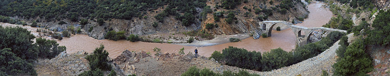
English: 17-18 century bridge - Kompsatos river, Thrace, Greece. It has opening 21,8 meters, height 12 meters. The east part has opening 17 meters.
Ελληνικά: Τοξωτή γέφυρα 17-18ου αιώνα, Ποταμός Κομψάτος, Ροδόπη, Θράκη, Ελλάδα. |
| Date | |
| Source | Own work |
| Author | User:Ggia |
| Permission (Reusing this file) |
Creative Commons License 3.0 Share-Alike |
This image was created with Hugin.
| Camera location | | View this and other nearby images on: OpenStreetMap |
|---|
Licensing
[edit]
I, the copyright holder of this work, hereby publish it under the following license:
This file is licensed under the Creative Commons Attribution-Share Alike 3.0 Unported license.
- You are free:
- to share – to copy, distribute and transmit the work
- to remix – to adapt the work
- Under the following conditions:
- attribution – You must give appropriate credit, provide a link to the license, and indicate if changes were made. You may do so in any reasonable manner, but not in any way that suggests the licensor endorses you or your use.
- share alike – If you remix, transform, or build upon the material, you must distribute your contributions under the same or compatible license as the original.
File history
Click on a date/time to view the file as it appeared at that time.
| Date/Time | Thumbnail | Dimensions | User | Comment | |
|---|---|---|---|---|---|
| current | 15:33, 15 June 2011 | 11,062 × 2,167 (24.5 MB) | Ggia (talk | contribs) | more light in the image | |
| 00:44, 27 September 2010 | 11,062 × 2,167 (22.99 MB) | Ggia (talk | contribs) |
You cannot overwrite this file.
File usage on Commons
The following 3 pages use this file:
File usage on other wikis
The following other wikis use this file:
- Usage on da.wikipedia.org
- Usage on el.wikipedia.org
- Usage on en.wikipedia.org