File:1873 U.S. Coast Survey Chart or Map of the Chesapeake Bay and Delaware Bay - Geographicus - ChesapeakeBay-uscs-1873.jpg

Original file (4,340 × 6,000 pixels, file size: 5.67 MB, MIME type: image/jpeg)
Captions
Captions
| Sketch C Showing the Progress of the Survey in Section III From 1843 to 1873. | ||||||
|---|---|---|---|---|---|---|
| Artist | ||||||
| Title |
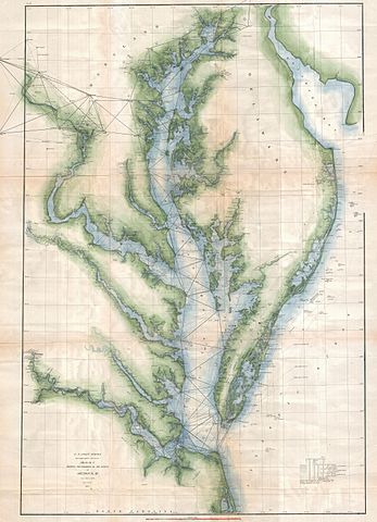
Sketch C Showing the Progress of the Survey in Section III From 1843 to 1873. |
|||||
| Description |
English: An exceptional example of the 1873 U.S. Coast Survey's progress chart for the Chesapeake Bay and Delaware Bay Region. Covers from the mouth of the Susquehanna to Back Bay North Carolina, west as far as Washington D.C. and Richmond, and east as far as Cape May. Shows triangulation points throughout the Bay as well as all major Island Rivers and inlets. Lighthouses, ports, cities, beaches, and industrial sites noted. Prepared under the supervision of Benjamin Peirce for the 1873 Superintendent's Report . |
|||||
| Date | 1873 (dated) | |||||
| Dimensions | height: 35 in (88.9 cm); width: 24 in (60.9 cm) | |||||
| Accession number |
Geographicus link: ChesapeakeBay-uscs-1873 |
|||||
| Source/Photographer |
Report of the Superintendant of the United States Coast Survey, Washington, (1873 edition).
|
|||||
| Permission (Reusing this file) |
|
|||||
File history
Click on a date/time to view the file as it appeared at that time.
| Date/Time | Thumbnail | Dimensions | User | Comment | |
|---|---|---|---|---|---|
| current | 14:38, 24 March 2011 | | 4,340 × 6,000 (5.67 MB) | BotMultichillT (talk | contribs) | {{subst:User:Multichill/Geographicus |link=http://www.geographicus.com/P/AntiqueMap/ChesapeakeBay-uscs-1873 |product_name=1873 U.S. Coast Survey Chart or Map of the Chesapeake Bay and Delaware Bay |map_title=Sketch C Showing the Progress of the Survey in |
You cannot overwrite this file.
File usage on Commons
The following 3 pages use this file: