File:1850 Topografische kaarten van Amsterdam en omgeving.jpg

Original file (10,521 × 6,976 pixels, file size: 17.34 MB, MIME type: image/jpeg)
Captions
Captions
Summary
[edit]
| Description |
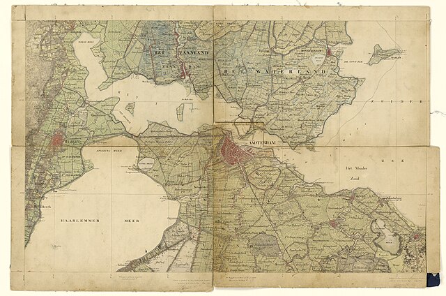
English: Topografische kaarten van Amsterdam en omgeving
Aalsmeer, Abcoude, Amsterdam, Ankeveen, Bennebroek, Beverwijk, Broek, Diemen, Haarlem, Haarlemmermeer, Heemstede, IJ, Ilpendam, Marken, Monnickendam, Muiden, Muiderberg, Naarden, Naarden, Naardermeer, Noord-Holland, Sloten, Sloterdijk, Spaarndam, Velsen, Weesp, Wijkermeer, Zaandam Nettekeningen 1:50.000 van de veldminuten ten behoeven van de Topografische Militaire Kaart, 1850-1864 |
| Date | |
| Source | http://proxy.handle.net/10648/af8c7032-d0b4-102d-bcf8-003048976d84 |
| Author | Unknown author |
Licensing
[edit]
|
This work is in the public domain in its country of origin and other countries and areas where the copyright term is the author's life plus 70 years or fewer. This work is in the public domain in the United States because it was published (or registered with the U.S. Copyright Office) before January 1, 1929. | |
| This file has been identified as being free of known restrictions under copyright law, including all related and neighboring rights. | |
File history
Click on a date/time to view the file as it appeared at that time.
| Date/Time | Thumbnail | Dimensions | User | Comment | |
|---|---|---|---|---|---|
| current | 22:04, 10 April 2017 | | 10,521 × 6,976 (17.34 MB) | Gladiool (talk | contribs) | Upload original file (less compression) |
| 23:41, 31 August 2015 |  | 10,521 × 6,976 (15.67 MB) | Hannolans (talk | contribs) | User created page with UploadWizard |
You cannot overwrite this file.
File usage on Commons
The following 2 pages use this file:
- File:Amsterdam 1850 001.jpg (file redirect)
- Category:IJ
File usage on other wikis
The following other wikis use this file:
- Usage on arz.wikipedia.org
- Usage on ceb.wikipedia.org
- Usage on de.wikipedia.org
- Usage on es.wikipedia.org
- Usage on fr.wikipedia.org
- Usage on gl.wikipedia.org
- Usage on he.wikipedia.org
- Usage on nl.wikipedia.org
- Usage on nn.wikipedia.org
- Usage on no.wikipedia.org
- Usage on pt.wikipedia.org
- Usage on ro.wikipedia.org
- Usage on www.wikidata.org